Decoding El Nino Over the Pacific: Resembles 'Canonical'


Representational Image: AI-Skymet
Key Takeaways:
- Niño 3.4 reached 1.5°C on 03 August 2026, touching the temperature anomaly threshold associated with strong El Niño conditions.
- Sharp warming in the eastern Pacific alongside cooling in Niño 4 indicates that the equatorial Pacific is heading towards a Canonical El Niño pattern.
- Canonical El Niño events can increase the risk of severe rainfall deficits across central, western and parts of northern India, with the second half of the monsoon particularly vulnerable.
- The Indian Ocean Dipole stood at +0.63°C for the week ending 02 August, while models suggest a positive IOD may develop by September 2026.
- Forecast Validity: Until next update.
Advertisement
The Indian Summer Monsoon (ISM) rainfall is often influenced by El Nino Southern Oscillation (ENSO) on the interannual time scale. El Nino events are usually divided into three types depending upon the warming pattern over the Central and Eastern Equatorial Pacific Ocean. A routine or a normal El Nino occurs when the warming along the equatorial Pacific region hosting the Nino indices is more or less uniform, but with a slender edge around the Nino 3.4 region.
Advertisement
Eastern Pacific El Nino is a classic pattern associated with ‘Canonical’ El Nino. This is also popularly called conventional or cold-tongue El Nino. In this case, the strongest sea surface temperature warming occurs in the far eastern equatorial Pacific near the coast of South America (Peru). In some extreme cases, the west and central Pacific regions observe negative SST anomalies when El Nino is full-blown. A canonical El Nino, especially when it reaches Super El Nino strength, affects the Indian Monsoon more severely. The intense warming across the central and eastern Pacific Ocean, in such a case, heavily disrupts the Walker Circulation and suppresses the rainfall over the Indian subcontinent.
The Central Pacific El Nino is called ‘Modoki’ El Nino, wherein maximum warming is centered in the mid-Pacific around the International Date Line. And therefore, it is also called dateline El Nino or warm-pool El Nino. It produces different atmospheric pressure patterns and distinct rainfall shifts, affecting North America, East Asia and surrounding regions differently than the eastern variants.
Physical mechanisms that link the Canonical El Nino and ISM rainfall have been well documented. But only a few studies have discussed the pathways that link El Nino Modoki and ISM rainfall variations. During a Canonical El Nino, the specific areas and states facing the highest variability include Madhya Pradesh and Chhattisgarh over central parts, Maharashtra (especially Marathwada & Vidarbha) and Gujarat (Saurashtra & Kutch) over western India, and major agricultural blocks of Rajasthan, Uttar Pradesh and the Haryana-Delhi region in northwest India. The eastern and southern parts covering Bihar, Jharkhand, Odisha and North Interior Karnataka-Andhra Pradesh also bear the risk of below-normal rainfall. Based on these studies, it is observed that El Nino Modoki modulates ISM rainfall by inducing changes in the Western North Pacific (WNP) low-level circulation. It was found that rainfall anomalies were negative over Southern Peninsular India and positive over the central parts.
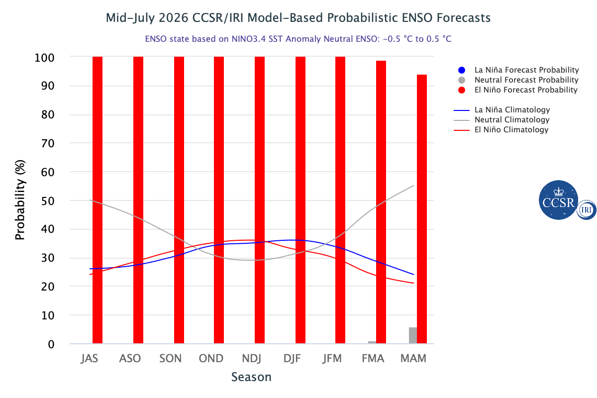
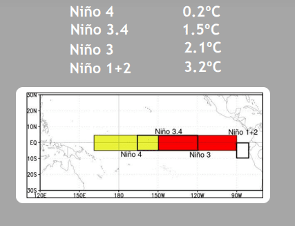
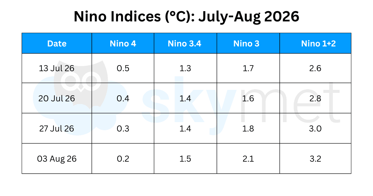
ENSO: The equatorial SSTs are above average across the central and eastern Pacific Ocean. The atmospheric circulation anomalies over the equatorial Pacific Ocean are consistent with El Nino. The variation in the temperature anomalies in the Nino region is bizarre. While the extreme western parts of the Nino region hosting Nino 4 have been cooling at a steady rate, the farther end hosting Nino 1+2 is literally exploding with warmth. The temperature anomaly in the Nino 4 region has declined from 0.8°C on 22nd June to 0.2°C on 03rd Aug 2026. The Nino 1+2 anomaly has risen from 2.1°C to 3.2°C during this period. The Nino 3.4 region, the marker index for El Nino, has risen incrementally from 1.2°C on 29th June to 1.5°C on 03rd Aug 2026.
The study of the temperature profile indicates that the equatorial Pacific is heading for ‘Canonical’ El Nino. During Canonical El Nino, the eastern Pacific Ocean gets warmed much more than the central and western Pacific. Even negative temperature anomalies are not very uncommon at the time of peak El Nino. During the Canonical event, the regions worst affected by severe rainfall deficit droughts are predominantly located in central, western and parts of North India. Also, the second half of the monsoon season behaves more erratically and becomes vulnerable to extremely poor rainfall in some pockets.
Advertisement
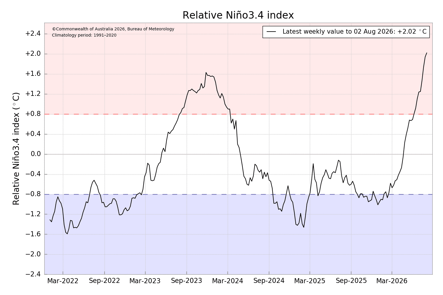
Nino 3.4 temperature anomaly has warmed to 1.5°C, the threshold of strong El Nino. The index needs to sustain temperatures above 1.5°C for the next few weeks to establish strong El Nino bounds, for the first time since Aug 2023. The Bureau of Meteorology Australia follows different standards for El Nino and, as per the Bureau, El Nino is considered when sustained monthly values of the Relative Nino 3.4 index are above 0.8°C. The U.S. Climate Prediction Center (CPC) uses the threshold of +0.5°C as a marker of El Nino. As per CPC, the temperature anomaly range for strong El Nino is +1.5°C to 1.99°C and for very strong El Nino, +2°C and above. According to data from the Bureau, the Relative Nino 3.4 index reached 2.02°C during the week ending 02nd Aug 2026.
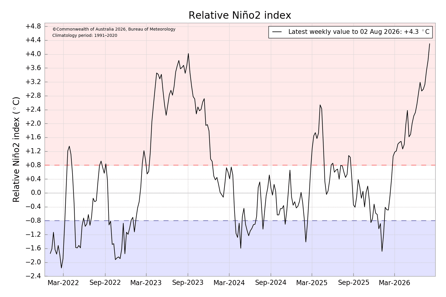
This is the first time that the Bureau’s weekly index exceeded 2°C since Feb 2016. While the weekly index crossing +2°C is a milestone, it will need to remain above this threshold for several weeks to be recognized as a very strong El Nino event. As per the Bureau, the Nino 2 region, next to the South American Coast, has exceeded a temperature anomaly of 4°C and the latest weekly value was +4.3°C on 02nd Aug 2026. As against these anomalies, CPC has scaled the Nino 1+2 region with a temperature anomaly of 3.2°C for the week ending 03rd Aug 2026.
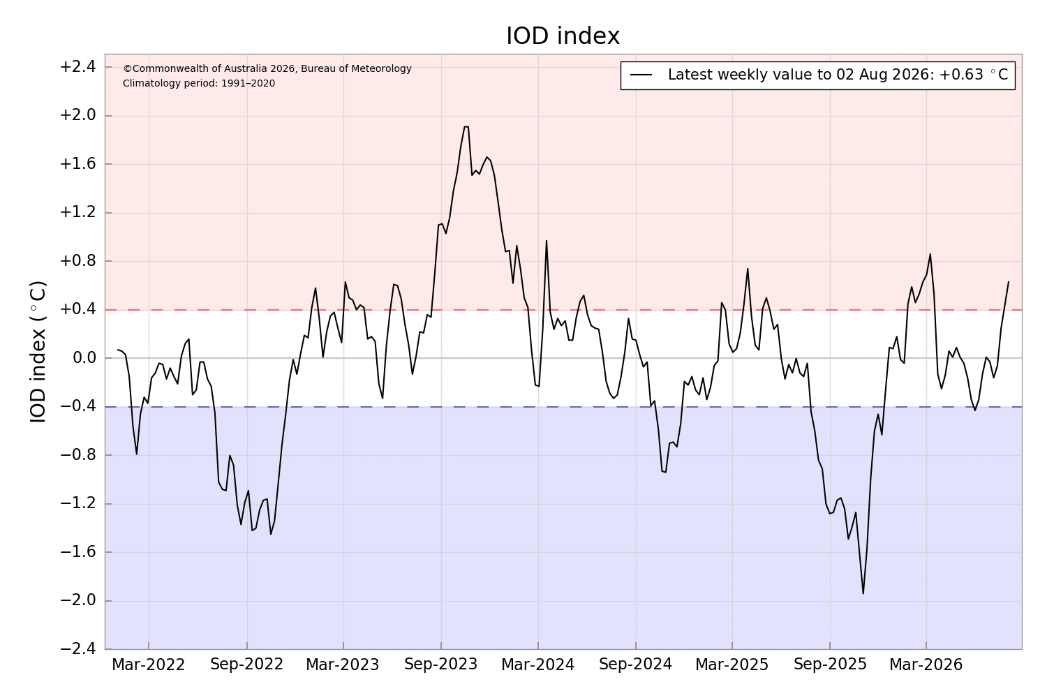
IOD: The Indian Ocean Dipole continues to remain above the positive threshold of +0.4°C for the second consecutive week. The index value for the week ending 02nd Aug 2026 was +0.63°C. Sustained positive values above the threshold are required for 7-8 weeks before the event is considered established. Models suggest a positive IOD may develop by Sep 2026, although there remain some variations in the timings and strength of this potential event.
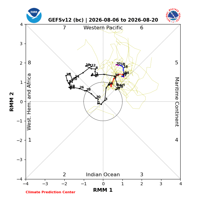
MJO: The Madden-Julian Oscillation is confined to the inner circle, bearing the least amplitude. MJO reached its point of peak destructive interference with El Nino as it entered the Indian Ocean during the past week. MJO will propagate eastward into the Maritime Continent (Phase 5 & 6), with a restrengthening signal. A constructively interfering MJO favours high chances of tropical cyclone development in the West Pacific. A very strong Typhoon Dolphin, now weakened to a Cat-I storm, is likely to strike the South Coast of China during the intervening night of 09th and 10th Aug 2026. Another storm, CHAN-HOM, will follow soon and possibly head for South Japan. El Nino-related shearing and unfavourable phasing of MJO do not support active monsoon systems over the Indian Seas. Moderate El Nino conditions are now on the verge of transitioning to strong El Nino. Temperature anomalies in excess of 1.5°C need to be sustained for a few weeks to qualify for the event. The temperature rise over the Nino 3.4 region may not be rapid enough to cross over to strong El Nino during August 2026.