Central Pacific Warming Quite Slow: IOD Cross Positive Threshold

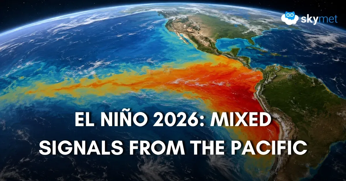
Representational Image: AI-Skymet
Key Takeaways:
- El Niño 2026 is strengthening, but warming across the Pacific remains uneven and below super El Niño thresholds.
- The Niño 3.4 index has increased only marginally, while the Niño 4 region has cooled over the past month.
- The Indian Ocean Dipole has crossed the positive threshold but must remain elevated for several weeks to become an established event.
- The combined evolution of ENSO, IOD and MJO will play a crucial role in shaping the latter half of the 2026 monsoon and global weather patterns.
- Forecast Validity: Until next update
Advertisement
The Central Pacific hosting ENSO has a general depth of about 4,600 meters. The entire Pacific Ocean has an average depth of 4,280 meters and reaches a maximum depth of nearly 11,000 meters at its deepest trenches. The cold water below 1,000 meters stays stable at around 2°-4°C. The warm, sunlit surface layer averages 27°-30°C. The thermocline is the middle transition zone where temperature drops rapidly from the warm surface to 20°C and lower.
Advertisement
The Pacific is the largest ocean on planet Earth, and the heat energy of this ocean is a massive dynamic system driven by tropical sunlight absorption. This heat engine initiates ocean currents, warm and cold upwelling, and regulates the global climate through El Niño/La Niña cycles and global atmospheric circulation.
El Niño collapses the normal temperature structure across the equatorial Pacific by weakening the trade winds, allowing warm surface water to surge eastward. This modifies both the horizontal and vertical temperature gradients.
ENSO is one of the most extensively studied climate drivers on the planet. During the warm El Niño phase, enormous volumes of warm water release heat previously trapped in the deep ocean, reshaping weather patterns around the globe.
Advertisement
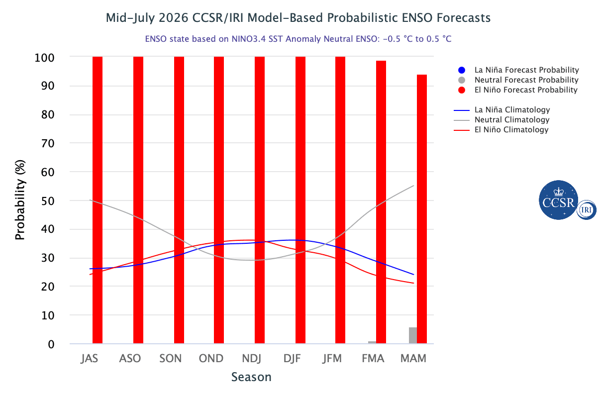
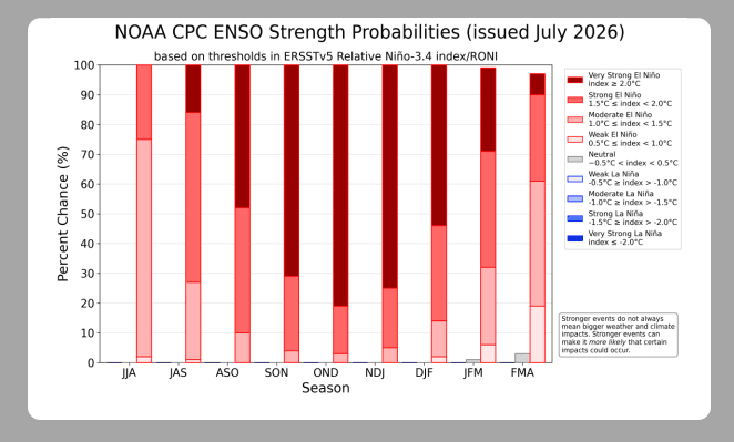
ENSO: How El Niño 2026 is shaping up in the Pacific remains a contentious issue. Forecasters expect the event to strengthen through the 2026-27 Northern Hemisphere winter, although its ultimate intensity remains uncertain. There is ambiguity about its peak period and duration as well. Notwithstanding its peak and intensity, El Niño does not cause the same weather everywhere and rarely repeats the same footsteps. However, it does raise the likelihood of climate extremes across many regions. Even the extreme El Niño events of the past spared India from their typical fury, as happened in 1997-98. Conversely, the mildest El Niño ruined the monsoon season and led to a severe drought in 2009. NOAA and the World Meteorological Organization say that the developing El Niño event could influence heat, rainfall, and storm patterns through the coming Northern Hemisphere winter, with impacts varying by location.
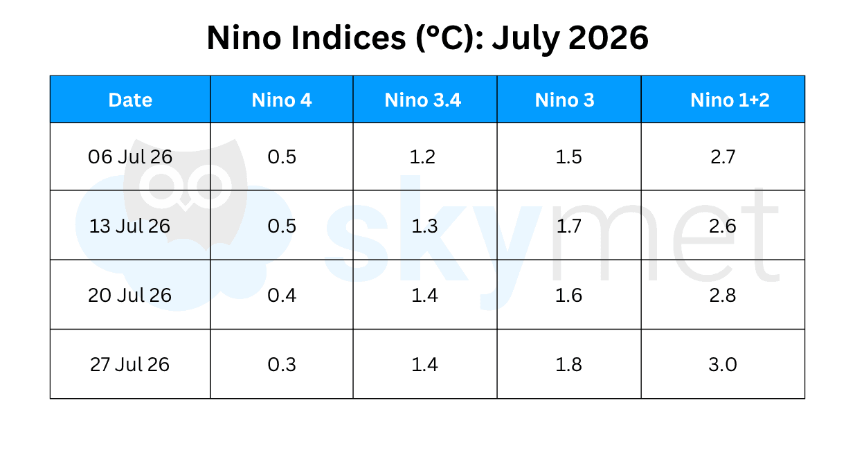
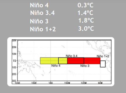
Niño indices have been displaying an incoherent pattern of ocean surface heating. The equatorial Pacific off the Peru coast has experienced rather explosive warming, with temperature anomalies reaching a massive 3°C. Earlier, such levels were achieved in July-August 2023 during the last El Niño event.
There has been a steady decline in the temperature anomaly of the Niño 4 region in the Central Pacific. The temperature anomaly has dropped from 0.8°C on 22nd June 2026 to 0.3°C on 27th July 2026.
Normally, during the build-up to a Super El Niño event, sea surface temperature anomalies in the Central Equatorial Pacific tend to exceed 2°C to over 3°C above normal, accompanied by massive subsurface warmth reaching up to +6°C down to 150 meters.
Even the Niño 3.4 region, the marker index of El Niño, is showing sub-par temperature elevation. The Niño 3.4 index has gained only 0.2°C in temperature anomaly, from 1.2°C on 29th June to 1.4°C on 27th July 2026. The warming pattern needs to be observed closely to gauge the intensity of El Niño during the second half of the monsoon season.
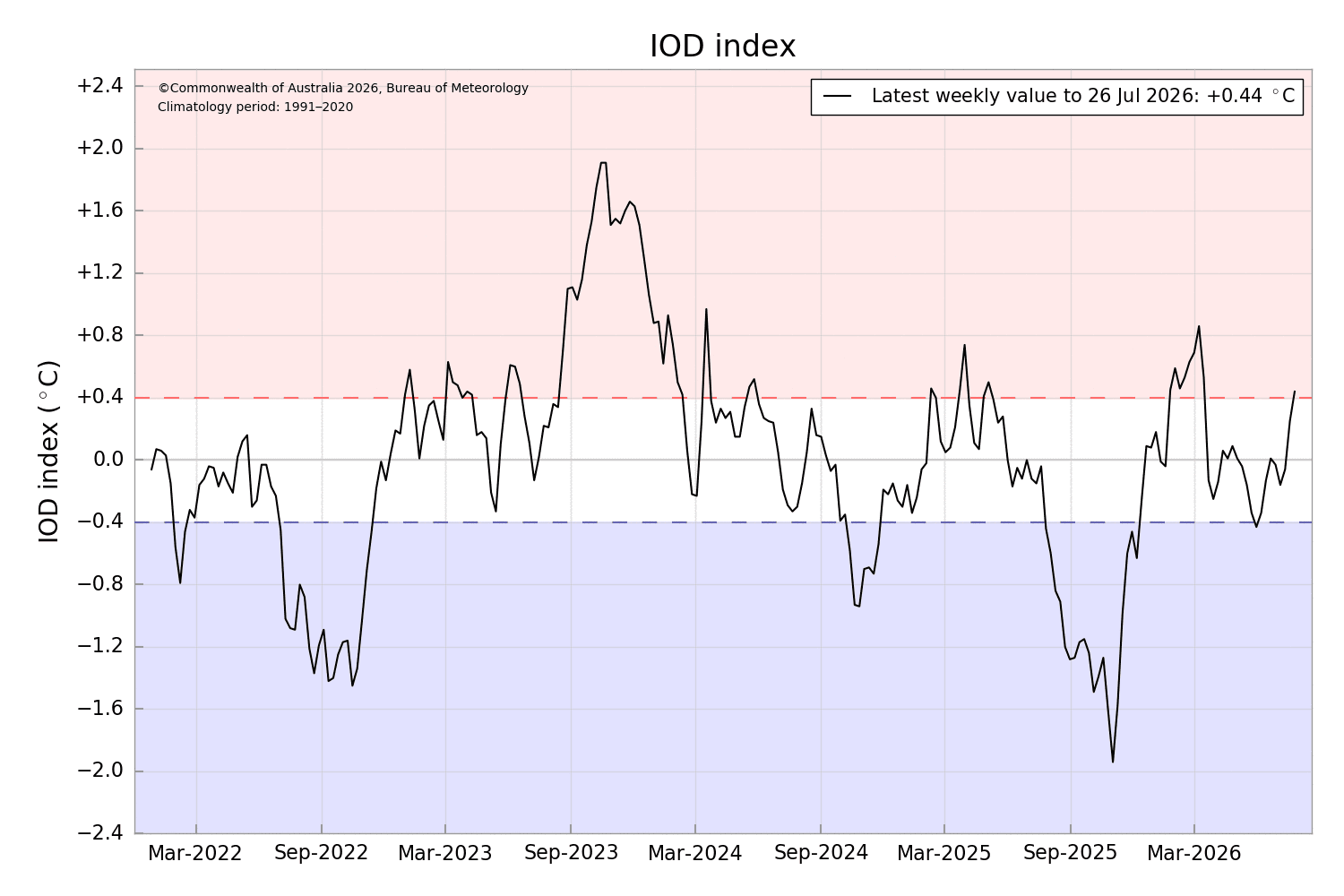
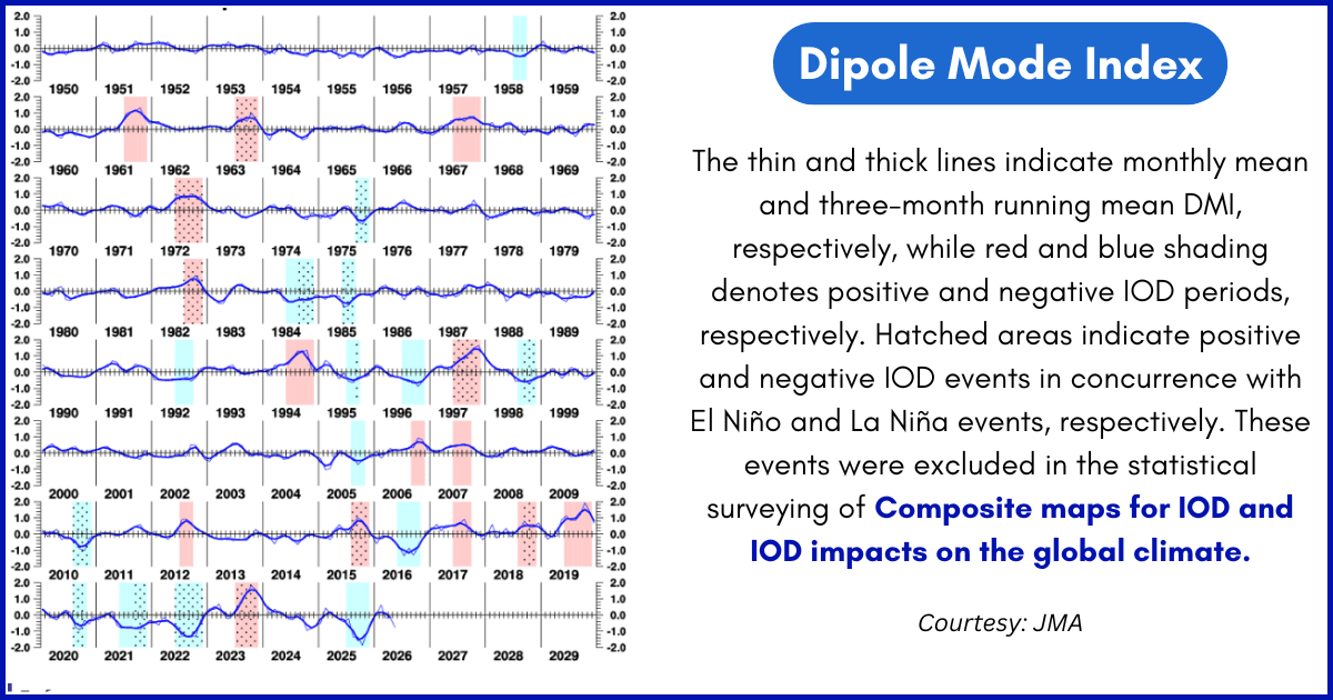
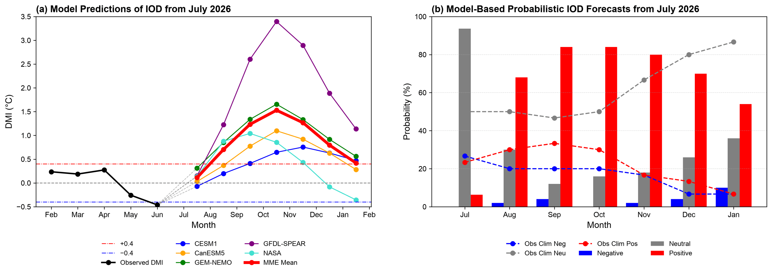
IOD: The Indian Ocean Dipole, by default, remains positive during El Niño years of the Indian summer monsoon. Yes, there is a degree of uncertainty about the magnitude of its peak intensity. The IOD is currently neutral.
The index value for the week ending 26th July 2026 was +0.44°C, warming by about 0.5°C over the past fortnight from +0.06°C, and almost doubling from the previous week's reading of +0.25°C on 19th July 2026. This is the first time since 15th March 2026 that the index has reached the positive IOD threshold (+0.4°C).
Such values, desirably higher in magnitude, need to sustain for about eight weeks before an event is considered established. Models suggest a positive IOD may develop during the second half of the monsoon and persist through the fall season. However, there remain some variations in the timing and strength of this potential event.
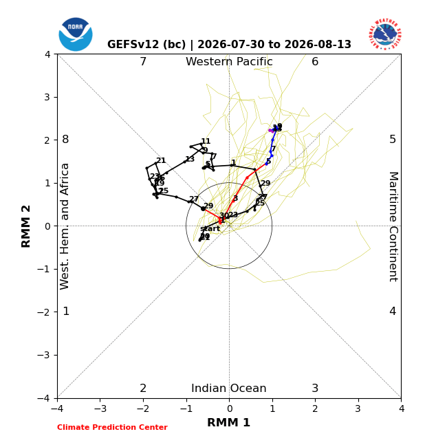
MJO: The Madden-Julian Oscillation has circumnavigated the globe at a slightly faster pace, completing the cycle in 30-40 days. It has encountered both constructive and destructive interference with the El Niño background state.
The MJO is likely to propagate from the Western Hemisphere to the Indian Ocean, but on a weakening note. Maintaining the least amplitude over the Indian Ocean, it will quickly move over the Maritime Continent and enter the Western Pacific during the second week of August. Across the Western Pacific, tropical cyclone activity is likely to shift farther east and potentially extend beyond the Date Line.
With oceans already warming at a much faster pace, scientists are watching more closely to see whether this latest El Niño amplifies global temperatures, making 2026 a contender for the hottest year on record. The lingering effects of the strong event are likely to cast a shadow even on 2027. After all, water has a long and deep memory and fails to cool rapidly.