

After witnessing intense summer heat and sky high temperatures, finally the state ofRajasthanhas started receiving good spell of rains from the past one week.
During the last 24 hours from 8:30 am on Friday, Barmer received 64 mm of rain followed by 42 mm of rain in Mount Abu. Other areas to have received good rains include Pilani 26 mm,Udaipur23 mm, Phalodi 14 mm, Churu 6 mm and Pali 4 mm.
[yuzo_related]
Southwest Monsoon has covered some more parts of Rajasthan and at present the Northern limit of Monsoon is passing through Barmer, Kota, Gwalior, Bareilly, Mukteshwar, Dharmshala, Bhadarwa and Pahalgam.
As per Skymet Weather, light to moderate rains will continue to pound many parts of East Rajasthan, whereas the rain activity will decrease over North and West Rajasthan. After 24 hours, rainfall activity is anticipated to decrease in south and southeast parts of Rajasthan, too.
All thanks to a low pressure area over Kutch and adjoining Rajasthan. A trough is also extending from this system to East Assam across South of Haryana, Uttar Pradesh and Bihar. Now this system is likely to weaken during the next 24 hours and a cyclonic circulation is expected over South Rajasthan that will move toward northeastwards. Another cyclonic circulation lies over North Rajasthan and adjoining parts of Punjab.
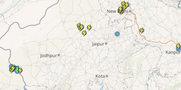
Take a look at the live lightning and thunderstorm status across Rajasthan
Besides this, moderate southwesterly winds from Arabian Sea are prevailing over Rajasthan and thus rain and thundershowers are expected to continue during the next 24 hours.
In the month of June, excess rainfall has been recorded by both divisions of the state. West Rajasthan is rain surplus by 174 percent, East Rajasthan by 42 percent.
Image Credit: pinterest.com
Any information taken from here should be credited to skymetweather.com


