Tidal Flooding: Why Kerala Declared It a ‘State-Specific Disaster’


Representational Image: AI-Skymet
Key Takeaways:
- Kerala has officially declared tidal flooding a state-specific disaster under the Disaster Management Act, 2005.
- The decision enables affected coastal residents to receive financial assistance from the State Disaster Response Fund (SDRF).
- Coastal districts like Ernakulam and Alappuzha are among the most vulnerable to recurring tidal inundation.
- Rising sea levels, land subsidence, and coastal changes are increasing the frequency of tidal flooding events.
Kerala has taken a landmark step towards disaster management as it declared tidal flooding (also known as coastal high-tide flooding or sea incursion) a "state-specific disaster" on January 30, 2026, under Section 2(d) of the Disaster Management Act, 2005. This appreciable step by the Kerala government has unlocked vital financial aid from the State Disaster Response Fund (SDRF) for victims in vulnerable coastal areas like Ernakulam and Alappuzha districts.
With this decision, the state became the first in India to formally recognise tidal flooding as a disaster, enabling affected families to receive financial assistance from the State Disaster Response Fund (SDRF) for loss of life, property damage, and livelihood disruption. The move reflects growing evidence that repeated tidal inundation is no longer a minor coastal nuisance but a persistent climate-linked hazard affecting vulnerable coastal communities.
What Is Tidal Flooding?
Tidal flooding is a type of coastal inundation caused mainly by unusually high ocean tides rather than heavy rainfall or overflowing rivers. It typically occurs during full or new moon phases, strong onshore winds, or periods of elevated sea level, allowing seawater to spill into low-lying coastal areas.
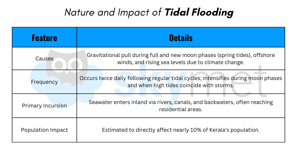
As global sea levels rise due to climate change, these once occasional “sunny-day floods” are becoming more frequent, affecting roads, homes, and agricultural land in coastal regions.
Areas Most Vulnerable to Tidal Flooding
Several coastal regions in Kerala are increasingly exposed to recurring tidal inundation. Districts such as Ernakulam and Alappuzha have emerged as major hotspots, particularly locations like Vypin, Chellanam, Edakochi, Kumbalanghi, and the Kuttanad region, which lies below sea level.
Estimates suggest that nearly 10% of Kerala’s population, around 3.5 million people, experience some level of tidal flood impact, while more than 20,000 residents across 23 coastal panchayats face seawater intrusion into homes during high tides.
Social and Economic Impact of Tidal Flooding
The recognition of tidal flooding as a state-specific disaster in Kerala in 2026 was largely driven by its growing social and economic consequences. Unlike sudden monsoon floods, tidal flooding occurs repeatedly, creating a cycle of chronic disruption for coastal communities and affecting livelihoods, infrastructure, and daily life across vulnerable regions.
Economic Impacts:
- Livelihood Disruption: Frequent seawater intrusion interrupts fishing activities, coastal farming, small businesses, and daily wage work, resulting in recurring income losses for many households.
- Agricultural Damage: Saline water gradually degrades farmland, damaging traditional coastal crops such as Pokkali paddy and affecting aquaculture activities like shrimp farming.
- Household Asset Loss: Continuous exposure to saltwater corrodes furniture, electrical appliances, and fishing equipment, increasing replacement and repair costs for families.
- Rising Adaptation Costs: Many residents invest substantial amounts each year to raise house foundations, strengthen embankments, or install pumps to remove floodwater.
- Declining Property Value: In several coastal areas, persistent tidal flooding has forced residents to abandon homes, leading to falling property values and long-term economic insecurity.
Social Impacts
- Climate-Induced Migration: Repeated flooding in vulnerable coastal villages is forcing some residents to relocate, creating a growing pattern of climate-driven displacement.
- Public Health Concerns: Stagnant saline water increases the risk of waterborne diseases, while saline intrusion in drinking water sources has been linked to rising health risks.
- Daily Lifestyle Disruption: Coastal households often adjust their routines around tidal cycles, frequently shifting belongings and managing repeated water ingress during high tides.
- Psychological Stress: Living with the constant threat of tidal flooding creates anxiety and uncertainty among residents, particularly during periods of high tides or rough sea conditions.
- Vulnerable Communities at Risk: Socially and economically marginalised groups, including inland fishing communities and daily wage workers, are often the most affected due to limited resources for adaptation.
Together, these economic and social pressures highlight why tidal flooding is increasingly being recognised not merely as a seasonal inconvenience but as a long-term climate risk requiring coordinated disaster management and resilience planning.
Community Resilience: The Role of EQUINOCT
As tidal flooding intensifies along Kerala’s coast, community-driven initiatives have become central to local adaptation and preparedness. One of the most prominent organisations supporting this effort is EQUINOCT Community Sourced Modelling Solutions, a Kochi-based social enterprise working to bridge the gap between scientific climate research and ground-level realities in vulnerable coastal settlements.
Who Is EQUINOCT?
Established in the aftermath of the 2018 Kerala floods, EQUINOCT (Enhancing the Quality of Life through Innovation and Networking, Offsetting Climate Change Impacts Using Appropriate Technology in the Tropics) focuses on participatory disaster management and climate data collection.
The organisation highlights a crucial gap in conventional climate modelling: while large-scale models can estimate sea-level rise and regional flood risks, local communities often possess the most precise knowledge about where flooding actually occurs — which culvert overflows, which road submerges, and which homes are affected during a specific high tide.
Key Community Resilience Initiatives
EQUINOCT’s approach converts affected residents into “citizen scientists”, enabling communities to collect and share hyper-local flood data that supports disaster planning and response.
- Tide Calendars for Coastal Households: More than 10,000 households across coastal Kerala have been provided with specially designed tide calendars. Residents record the timing, duration, and depth of tidal flooding, helping build a local dataset on recurring flood patterns.
- Community-Operated Tidal Gauges: In several villages, residents have installed simple manual tidal gauges using bamboo poles and measuring tapes to track water levels in courtyards and streets.
- Participatory Flood Mapping: In collaboration with Kudumbashree, Kerala’s women-led poverty eradication mission, volunteers have mapped flood-prone areas across around 25 coastal Local Self Government (LSG) regions, identifying vulnerable households and blocked drainage routes.
- The “Gather” Climate Dashboard: Launched in late 2024, the Gather app and climate dashboard aggregates data from over 100 community-operated rain gauges and tidal sensors, providing near real-time impact-based flood insights to district authorities.
- Women-Led Data Collection: Around 90% of the volunteers involved in calendar distribution and flood mapping are women, improving the accuracy and consistency of community-generated flood data.
What Caused the Increase in Tidal Flooding Incidents in Kerala?
Tidal flooding incidents in Kerala have surged due to a combination of climate-driven sea-level rise, local land subsidence, and human-induced factors worsening coastal vulnerability.
Primary Climate Factors
Global warming is causing sea levels to rise along Kerala's 550-km coastline. Long-term observations show Kochi’s mean sea level increasing measurably over the decades, allowing high tides — particularly spring tides during full and new moons — to travel farther inland through backwaters, rivers, and canals.
Warmer oceans and shifting weather patterns further amplify the phenomenon, turning occasional nuisance flooding into more frequent year-round events.
Local Subsidence and Topography
Kerala’s low-lying coastal plains, including Kuttanad (below sea level) and several areas around Kochi, are experiencing land subsidence, in some locations occurring two to five times faster than the rate of sea-level rise. Natural land sinking combined with urbanisation increases the risk of tidal inundation even during minor tidal surges.
Human and Environmental Contributors
River and lake siltation reduces drainage capacity, while unplanned development near water bodies and floodplains obstructs natural water flow. Coastal storms coinciding with high tides, shoreline erosion, and geomorphic changes further compound flooding risks across multiple coastal districts.
What Long-Term Strategies Is Kerala Implementing Against Sea Level Rise?
Kerala is implementing several long-term strategies to address sea-level rise through integrated coastal zone management, infrastructure upgrades, and community-based climate adaptation.
Integrated Coastal Zone Management
The state emphasises coastal defence measures, mangrove restoration, and regulated development through Coastal Regulation Zone (CRZ) policies. Scientific High Tide Line (HTL) mapping using geospatial tools helps monitor shoreline changes and enforce coastal planning regulations.
Infrastructure and Drainage Upgrades
Efforts include river desiltation, improving backwater flow, and strengthening drainage systems to manage tidal water intrusion. Sea-level projections — estimated between 0.6 and 1.1 metres by 2100 around Kochi — are increasingly being incorporated into long-term urban planning.
Community and Ecosystem Resilience
Community-based approaches supported by organisations such as EQUINOCT involve participatory mapping, early-warning awareness, and ecosystem-based protection such as mangrove bio-shields. These initiatives complement efforts by the Kerala State Disaster Management Authority (KSDMA) to strengthen bottom-up climate resilience.
From a meteorological perspective, strengthening coastal observation networks, tide-gauge monitoring, rainfall forecasts, and early-warning systems will be critical in reducing the impacts of future tidal floods.
Kerala’s decision to formally recognise tidal flooding as a disaster highlights a broader reality: while sea-level rise is gradual, its impacts on coastal communities can be immediate.