Cold Wave To Continue In Delhi: Mercury May Dip Further

Key Takeaways
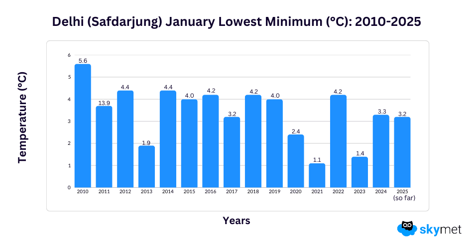
- Delhi recorded its coldest morning of the season, with Safdarjung touching 3.2°C and Palam 3.3°C.
- Palam’s 3°C yesterday was the lowest in 13 years for the station.
- Cold wave conditions are expected to continue till the weekend, with another cold morning likely tomorrow.
- Slight relief is possible around 16–17 January, with chances of winter rain between 18 and 21 January.
Cold wave conditions have spread further and covered most parts of Delhi this morning. The capital city, as such, has been recording extreme cold conditions over many parts, intensifying cold wave conditions. Base station Safdarjung recorded the coldest morning of this season and also for the last two years. The record observatory plunged to 3.2°C, first under 4°C for the city records and the second cold wave day of the season. Airport observatory Palam was a whisker higher at 3.3°C, registering the second successive cold wave day. Earlier, Palam recorded 3°C yesterday, the lowest of this season and also of NCR.
Palam had recorded the lowest minimum temperature of the last 13 years at 3°C yesterday. The observatory had earlier registered a minimum of 2.6°C on 07th Jan 2013, the lowest in the last about two decades. The observatory has an outlier record of going sub-zero and slipping to an all-time low of -2.2°C on 11th Jan 1967. Safdarjung is second to Palam and holds the lowest record of -0.6°C, registered on 16th Jan 1935. This observatory may breach a temperature of 3°C or less tomorrow. Most parts of Delhi will remain in the range of 3°–4°C tomorrow, recording a hat-trick of cold wave days. Last year, there was no cold wave day recorded by this station in January.
Delhi is likely to remain under the clout of cold wave or severe cold wave till this weekend. The earliest relief may be possible around 16th and 17th January. Under the influence of the approach of a western disturbance, the wind pattern may shift to southeasterly in the lower levels. The arrest of freezing winds blowing down the slopes, increase in humidity, and slowing down of breeze may take the pinch out, albeit marginally, on these two days. When it happens, the capital city can look for a bigger change commencing next weekend on Sunday. Though it is too early to commit, the first decent winter showers may happen between 18th and 21st Jan 2026.