Western Disturbance not yet over and done, heavy snow to lash Shimla, Kullu and Manali again

January 27, 2020 9:37 AM|

hills snowfall

The month of January is just going to end and it seems like the Western Disturbance is in no mood to spare the northern hills anytime soon. So if you are planning a trip to the hills during this week, we advise you to reconsider your plans, as another heavy rain and snow spell is going to hit the hilly region within next 24 hours.

At present, afresh Western Disturbanceis over North Pakistan and adjoining Jammu and Kashmir. The system is soon going to reach the Western Himalayas. This time, it has also induced a Cyclonic Circulation over Central Pakistan and adjoining Rajasthan,indicating rain in the northern plains.

According to our meteorologists, a fresh spell ofrain and snow may commence in parts of Jammu and Kashmir as well as Ladakhby today afternoon. As time progresses, these activities are expected to spread up to parts of Himachal Pradesh and Uttarakhand as well.

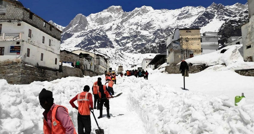
Moderate to heavy rain and snow may drench almost all the famous tourist destinations right from Srinagar, Pahalgam, Kullu, Manali, Shimla to Kedarnath, Badrinath, Nainital until January 28.

Considering heavy snowfall in some parts, chances of landslides, mudslides as well as avalanches in the prone areas cannot be ruled out. Hence, tourists are advised to take all the necessary precautions.

From January 29, due to the eastward movement of the weather system, the weather activities are expected to taper from the region. However, rain and snow may continue with good intensity in parts of Uttarakhand for some more time.

Image Credits – The Statesman 

Any information taken from here should be credited to Skymet Weather

Similar Articles

thumbnail image
March 20, Today Marks The Spring Equinox: Day-Night Duration Nearly Equal

The official transition from winter to spring, known as the SPRING EQUINOX, occurs today! It’s time when the Sun crosses the celestial equator precisely at 2:31 PM, delivering warmer, longer days to the Northern HemiSphere. As autumn arrives, the South enjoys colder evenings.

posted on:
thumbnail image
आज सूर्य करेगा भूमध्य रेखा पार, बसंत ऋतु की शुरुआत, दिन-रात की अवधि लगभग बराबर

आज, 20 मार्च 2025, बसंत विषुव (Spring Equinox 2025) का दिन है। सूर्य भूमध्य रेखा को पार करेगा, दिन बड़े और गर्म होंगे। उत्तर गोलार्ध में बसंत ऋतु की शुरुआत होगी, दक्षिण गोलार्ध में शरद ऋतु का आगमन होगा। वहीं, सितंबर में यह खगोलीय घटना फिर से होगी।

posted on:
thumbnail image
गर्मी का दायरा बढ़ा! ओडिशा, महाराष्ट्र, तेलंगाना और रायलसीमा में 40°C के पार तापमान, राहत की उम्मीद

देश में समय से पहले गर्मी असर बढ़ रहा है। ओडिशा, महाराष्ट्र, तेलंगाना, आंध्र प्रदेश में अभी तापमान से 40°C से ऊपर पहुंच गया है, जिस कारण इन राज्यों में भीषण गर्मी हो रही है। फरवरी 2025, पिछले 125 वर्षों में सबसे गर्म महीना रहा है। कई जगहों पर सामान्य से 6.4°C तक ज्यादा तापमान रिकॉर्ड हुआ है।

posted on:
thumbnail image
दिल्ली में बढ़ेगी गर्मी! शुष्क और तपता रहेगा वीकेंड, बारिश की संभावना हुई कम

दिल्ली में गर्मी बढ़ रही है, पिछले 3 दिनों में तापमान 4°C बढ़ा है। आज अधिकतम 34-35°C, न्यूनतम 17°C तक रह सकता है। मार्च अब तक लगभग शुष्क बना हुआ है, सिर्फ 2mm बारिश दर्ज हुई है। 26-28 मार्च को तापमान 40°C के करीब पहुंचने की संभावना है। वहीं,पश्चिमी विक्षोभ से मैदानी इलाकों में बारिश की संभावना नहीं है।

posted on: