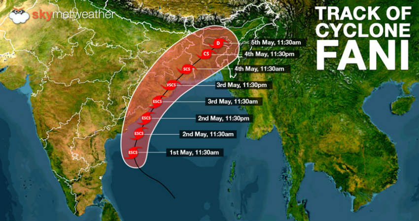
Extremely Severe Cyclone Fani over West-central Bay of Bengal has been gaining strength and continuously moving closer to the coast. It is now ready to make a landfall on the Odisha coast by the afternoon of May 3.
At present, its located at near latitude 15.5°N and longitude 84.2°E, about 430 km south-southwest of Puri, Odisha, 210 km south-southeast of Vishakhapatnam, Andhra Pradesh and 630 km south-southwest of Digha, West Bengal.
In the wake of this Cyclone, West Bengal is gearing up for some very heavy rains starting May 3. The Extremely Severe Cyclonic Storm Fani is going to make landfall over Odisha near Satpada and Balukhand area in Puri district by afternoon of May 3.
As Cyclone Fani is expected to move northeastwards, it will travel across Coastal districts of Odisha towards Gangetic West Bengal. However since, Fani would be then travelling over land, it would start weakening but would still sustain a strength of a cyclonic strength. Therefore, we expect intensity of rains to increase over entire West Bengal tomorrow onward.

In fact by evening of May 3, most parts of the state, will start receiving good rains. The most affected districts of West Bengal would be Bankura, Purulia, Medinipore, Hooghly, Bardhaman and Howra. The intensity of rains over these districts will be heavy to very heavy, along with destructive winds in the order of 40-60 gusting to 70-80- kmph. Local flooding in these districts cannot be ruled out.
On the other hand, Kolkata, 24 Pargana, Nadia, Murshidabad will also receive moderate to heavy rains. But intensity of these rains will be less as compared to the above-mentioned districts.
Skymet Weather has already issued an alert across the state against the cyclonic storm-
Weather Alert for West Bengal :
Heavy to very heavy with few extremely heavy thundershower with gale winds reaching 100-120 kmph gusting 140 kmph and intense lightning will affect many places over Alipurduar, Bankura, Bardhaman, Birbhum, Dakshin Dinajpur, Darjiling, Howrah, Hugli, Jalpaiguri, Kalimpong, Kooch Bihar, Kolkata, Maldah, Murshidabad, Nadia, North 24 Parganas, Paschim Medinipur, Purba Medinipur, Puruliya, South 24 Parganas and Uttar Dinajpur districts of West Bengal from 03 to 04 May 2019.
By evening of May 4 i.e. the day after tomorrow, rains will start reducing over Gangetic West Bengal, but Sub-Himalayan West Bengal will continue to receive good rains. Weather will clear up over most parts of West Bengal by May 5. However, due to increased moisture some localized weather activities cannot be ruled out. By this time, the temperature that would have fallen significantly will yet again start increasing.
The Sub-Himalayan West Bengal has been receiving good rains since last many days however the weather over Gangetic West Bengal is running almost dry. Although isolated rains occurred over here in the last 24 hours, but weather is still warm and humid.
Image Credits – Twitter
Any information taken from here should be credited to Skymet Weather


