La Nina event is continuing, with no acute signs of softening. Sea Surface Temperatures (SSTs) remain below average in the central-eastern equatorial Pacific Ocean. Conditions remain favourable for the continuation of weak La Nina, extending further the transition phase to ENSO neutral.
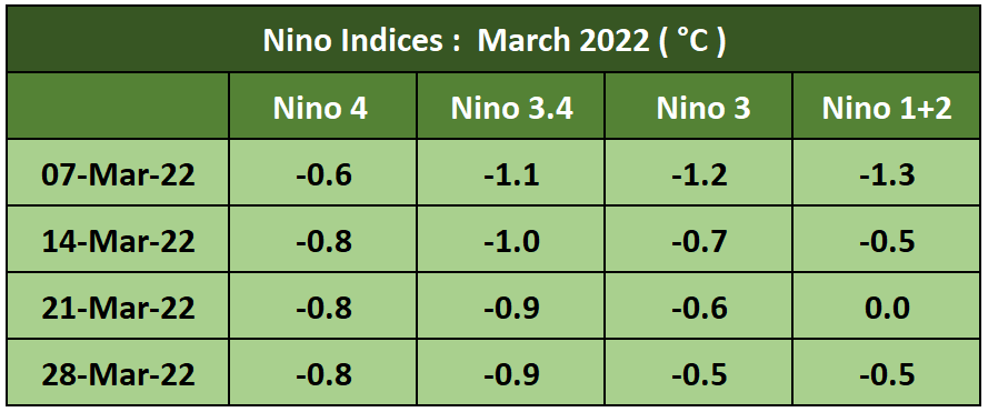
ENSO: La Nina had passed its peak in Jan 2022 and Nino indices started shrinking in February. However, from February end, not only did the rise of Nino indices got arrested, a marginal but steady drop is noticed again. Apparently, the strengthening of trade winds above the average, in the Western Pacific seems to be delaying further weakening of the La Nina over the past 4 weeks. Return to ENSO neutral is likely to get pushed further till the initial phase of onset of monsoon. Thereafter, even as La Nina weakens, it will continue to influence global weather and climate.

Mostly, all the indices are retaining values below the threshold of -0.5°C. The slow decline of indices is suggestive of the continuation of La Nina, albeit weak, well up to the spring season. Water has a tendency to retain its memory and therefore, rapid changes are not likely.

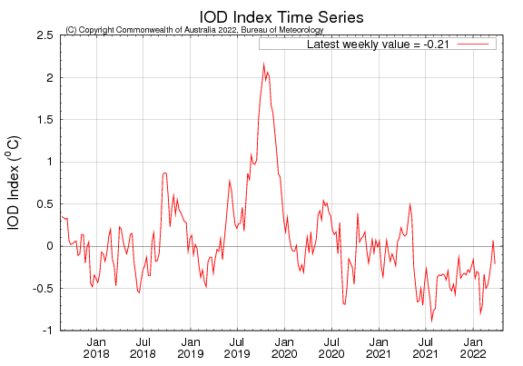
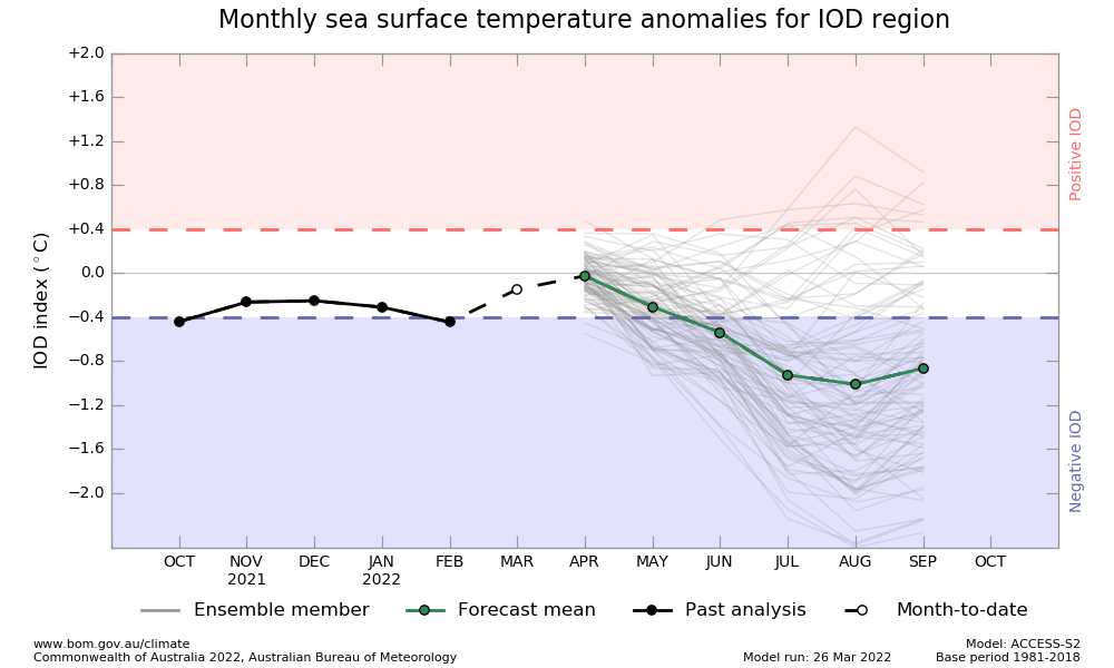
IOD: Indian Ocean Dipole is neutral. The latest weekly value of the IOD index on 27 March 2022 was -0.21°C. IOD projection shows -ve but within neutral limits at the time of commencement of monsoon.

The -ve component seems to be growing as the monsoon season advances. Most models have low accuracy beyond spring, at this point in time. Therefore, the IOD plot needs to be read with caution for the time being.

MJO: Madden Julian Oscillation has weakened as compared to its last appearance. It has nearly become imperceptible after moving over to the Maritime Continent. It is likely to remain weak for the next 2 weeks. Therefore, it may not enhance convective activity over the Indian Seas till mid-April.

While the ‘spring barrier’ will continue to influence ENSO in the Pacific Ocean, trade winds in the equatorial Indian Ocean will decide the shape of IOD over the Indian Seas. Inter-Tropical Convergence Zone (ITCZ) close to the equator in the Northern Hemisphere will become visibly sharp with long horizontal bands of convective clouds during April-May. An active ITCZ is the backbone of weather disturbances coming up in the Indian Seas during the pre-monsoon season.


