
Skymet Weather had predicted thatSouthwest Monsoon 2019would make onset over Kerala on June 4 (with an error margin of +/- 2 days). However, looking at the sluggish advancement of Monsoon, we expect that country would have to wait for some more days.
Present weather conditions are indicatingMonsoononset would be now around June 7 (with an error margin of +/- 2 days). “Dynamics of Monsoon keep changing. So far, not even one out of the three criteria needed for declaring the onset of Monsoon has been met. In fact, it would take some more days for conditions to become favourable for the same,” said AVM G P Sharma, President- Meteorology and Climate Change, Skymet Weather.
Monsoon 2019had made an appearance over Bay Islands on May 18, little early than its normal onset date of May 20. However, the progress of Monsoon has remained extremely sluggish thereafter or we can say practically stationary.
By May 27,Monsoon surge had covered some more parts of Andaman and Nicobar Islandsand by May 30, it covered significant portion of Bay of Bengal and Islands including Port Blair. Usually, by May 25, the Northern Limit of Monsoon (NLM) covers both Port Blair as well asSri Lanka.
Know the reasons behind the delay in Monsoon onset:
1. Low pressure area over Somalia Coast: There has been a low pressure area off the Somalia coast, which is governing the wind pattern. The system has taken away the moisture and has been restricting the consistent stream of westerly winds over western parts of Arabian Sea, which eventually reaches to Kerala.
2. Anti-Cyclone over Central Arabian Sea: We have already indicated that theanti-cyclone in Arabian Seais pushing northerly winds that too are blowing along the West Coast. These winds are not instrumental in giving rains over the coast.
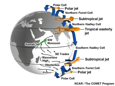
3. Somali Jet: It is a mandatory phenomenon for theonset of the Monsoonsurge. Somali Jet is the core of strong winds. These winds originate from Kenya, cross equator as a part of Cross-Equatorial flow while blowing along the Somali coast and finally entering Indian Ocean and moving towardsKerala. This pattern has not established so far.
Monsoon 2019: Road ahead
Weathermen at Skymet Weather are of the view that slowly and gradually, weather conditions would change. All the roadblocks in the journey of Southwest Monsoon are likely to dissipate in the coming 48 hours. However,arrival of the Monsoonwould not be sudden as establishment of favourable weather conditions would take some more days.
A vortex is expected to come up in Southeast Arabian Sea and adjoining Lakshadweep Islands around June 6. The system would be responsible for the onset of Monsoon over Kerala.
However, as reiterated, Skymet Weather do not expect a thumping beginning to theMonsoon 2019. It would be a weak onset as weather system does not promise sufficient rains. In fact, the Monsoon might go silent soon after making onset.
“The likely weather system would be moving away from the coast in westerly direction. It would be gaining strength gradually. As a result, moist winds would then be concentrating around the weather system, leading to drop in rainfall over the Indian landmass. Rains would only return as the system moves far away,” said G P Sharma.
Criteria needed for onset of Monsoon are:
1. Rainfall: The first and foremost guideline for the arrival ofMonsoonis increase in rainfall. Rule book says that after May 10, if 60 percent of the pre-decided 14 stations across Kerala, Karnataka and Lakshadweep Islands such as Minicoy, Amini Devi, Thiruvananthapuram, Punalur, Kollam, Alappuzha, Kottayam, Kochi, Thrissur, Kozhikode, Thalassery, Kannur, Kudlu and Mangalore record rainfall to the tune of 2.5 mm or more for two consecutive days, we can declare the onset over Kerala on the 2nd day, provided other criteria are also fulfilled.
2. Wind field: Second guideline is the wind field where in depth of westerlies should be up to 600 hPa, in the box equator to Latitude 10°N and Longitude 5°E to 80°E. The zonal wind speed over the area bounded by Latitude 5°N-10°N, Longitude 70°E-80°E should be of in the order of 15-20 Kts. at 925 hPa.
3. Outgoing Longwave Radiation (OLR): OLR value should be below 200 wm-2 in the box confined by Latitude 5°N-10°N and Longitude 70°E-75°E.
Image Credit: Indian Express
Any information taken from here should be credited to skymetweather.com