
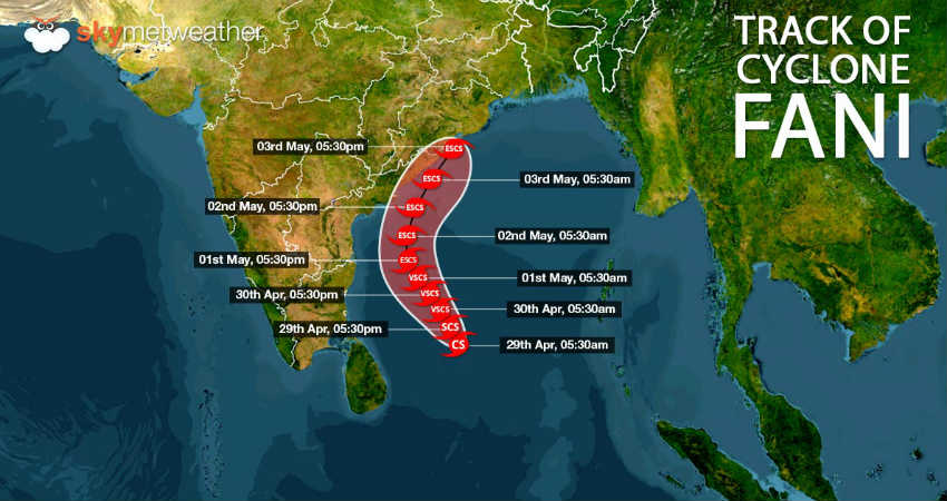
TheVery Severe Cyclonic Storm Faniover southwest and adjoining southwest Bay of Bengal is at present exactly abeam Chennai. It is centered at latitude 13.1°N and longitude 85.1°E, about 500 km from Chennai, 780 Km south of Puri, Odisha and 600 km south-southeast of Vishakhapatnam,Andhra Pradesh.
AlthoughFaniis maintaining enough distance from the coast but Tamil Nadu has now come in the ambit of the outer periphery of the very severe cyclonic storm. As a result, we can already see increase in clouding over the state. In fact, coastal areas are already witnessing increase in the wind speed to the tine of 40 kmph to 50 kmph.
Weather conditions are already favourable for light to moderate rains and thundershowers over parts of Tamil Nadu includingChennai, Madurai and Coimbatore during the next 24 hours. There are some chances that isolated pockets may receive short spells of intense rains. However, heavy to heavy rains that are usually associated with cyclone are completely ruled out.
Very Severe Cyclone Faniis likely to move northwestwards and intensify intoExtremely Severe Cycloneduring the wee hours of May 1, heading towards Odisha coast. As the system moves away, we do not expect any intense weather activities over Tamil Nadu but few showers cannot be ruled out.
The weather will remain cloudy for next two to three days, leading to a drop in day temperatures. No major threat can be seen in terms of heavy rains in the coastal areas, but strong winds would continue. Moreover, sea conditions will be rough to very rough for next two to three days, hence, fishermen are advised not to venture out in the sea for at least next 48 hours.
Also read: Fani intensifies into very severe cyclonic storm, to become extremely severe cyclone soon
By May 3, as Fani would move far beyond the reach of Tamil Nadu, the weather will start clearing up and sky will become sunny with appearance of isolated clouds over some parts.
Image Credits – Wikipedia.org
Any information taken from here should be credited to Skymet Weather


