The Southwest Monsoon season this year has been a little erratic. The onset over Kerala was delayed by almost a week from its usual date of June 1 and then the progress to the other parts of the country was also slow. The withdrawal now is playing games with forecast extending into the second week of October.
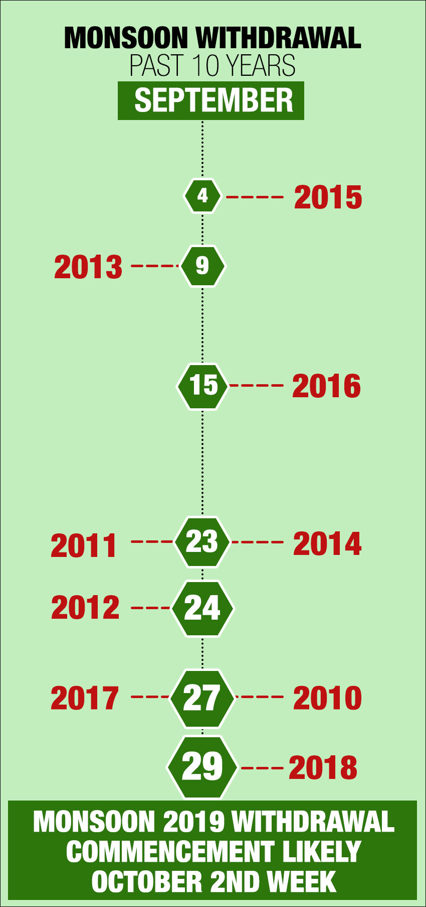
Theretreat of Monsoonbegins in the first week of September from Rajasthan -the first post for withdrawal and the last for Monsoon onset- but there are variability observed. In the last ten years the commencement of withdrawal has been as late as September 29 and early as September 4 but this year the withdrawal is going to create some kind of a record. The following table explains it.
 Starting with the performance from the Monsoon month of June, rainfall across the country was extremely poor as the month ended with a deficiency of a whopping 33%.
But as we entered the month of July the rainfall activity increased across the country and the month finished with an excess of 5%. August too witnessed some intense spells of rainfall activity to record a surplus of 15%. Central and South India were the best performing regions during this period. But it was a difficult period for Central India in particular as floods in Madhya Pradesh, parts of Rajasthan and Gujarat caused extensive damage.
The month of September trod the same path with some heavy rain again being observed in states like Madhya Pradesh, Gujarat, Rajasthan parts of Maharashtra, several parts of Uttar Pradesh and Bihar. Compared to the previous months the Southwest Monsoon has been more intense and widespread due to which the countrywide rainfall is surplus by 32% so far in this month.
Successive systems emerge delaying Monsoon withdrawal
Meanwhile, there is increased rainfall activity on both sides of the coastline. Normally towards the fag end of September formation of Monsoon systems take a backseat but currently, successive weather systems are affecting the country.
In the Arabian Sea, there was the Cyclone Hika affecting states like Gujarat, Rajasthan and Maharashtra, while on the other side the Cyclonic Circulation in the Bay of Bengal has moved inland giving good amounts of rain in Odisha, coastal Andhra Pradesh, Kerala and Konkan and Goa region.
In addition, two more Cyclonic Circulations have formed. One is over East Rajasthan and adjoining Madhya Pradesh, while the other one is over West Rajasthan and its neighbourhood.
According to senior meteorologists at Skymet, these systems are going to give some very good widespread rain in the country for at least a week or so covering entire Central India, parts of North India and East India. States like Madhya Pradesh, Maharashtra, Gujarat, Rajasthan, Punjab, Haryana, Delhi, Uttar Pradesh and Bihar will be affected.
This week-long spell of rain is therefore likely to delay the commencement of withdrawal of Southwest Monsoon to the second week of October.
Image Credit: reuters.com
Any information picked up from here should be attributed to Skymet Weather