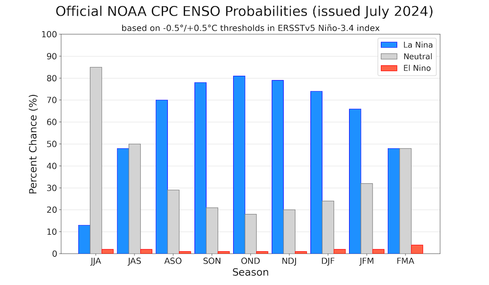
Normally, the transition from El Nino to La Nina marks a period of neutrality lasting 3 to 5 months before the full impact of La Nina is felt. However, if La Nina fails to intensify adequately, the ocean surface temperatures may remain high due to the lingering effect of El Nino. Despite being considered the ‘opposite’ of El Nino, La Nina effects are not really a mirror image of its counterpart. It is a bit more complicated than that. Rising global temperatures alter the dynamics of El Nino and La Nina cycles which has added a layer of uncertainty to weather forecasts. Scientists as such grapple with the complexities of climate change and natural variability, super imposition of El Nino and La Nina compound the changes further. As the arrival of La Nina is getting delayed, its impact is unlikely to have full effect over South and Southeast Asia.

ENSO: The US weather agency, Climate Prediction Center (CPC), has now joined other agencies in predicting that the emergence of La Nina has been impeded. Further, APEC Climate Center has also joined corroborating delayed arrival of La Nina. The research center also expects the cold event to bring increased rainfall to Asia, particularly India, from August 2024 to January 2025.

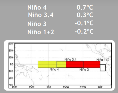
The Nino indices in the equatorial Pacific Ocean are nearly steady for the last four weeks. Central parts of equatorial Pacific are warmer than normal and the eastern parts, closer to the coastline are marginally below 0°C. Nino 3.4 region, the marker for the Oceanic Nino Index (ONI) is persistently warmer by 0.3°C – 0.4°C since 24thJune 2024. That is what is delaying, even the perfect ENSO neutral conditions. The cascading effect is leading to delay of La Nina conditions.
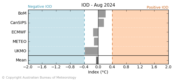
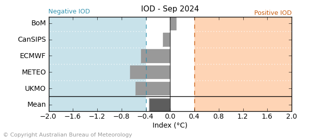
IOD: The Indian Ocean Dipole is maintaining sub-zero value for the last six weeks, since 09thJune 2024. The sea surface temperature has dropped further by 0.1°C since last week. The latest weekly IOD index for the week ending 14thJuly 2024 was -0.29°C. True to its character, negative IOD events are commonly linked to La Nina events. Majority of numerical models are pointing towards negative IOD, albeit within threshold, during August-September 2024.
MJO: There is fair amount of diversity amongst forecast models with regards to MJO evolution in the coming weeks. Few models favour a weak signal with marginally effective propagation, whereas section of some other models favour steady eastward propagation with increasing amplitude. Anticipated state of ENSO neutral and bullish forecast of MJO by few models favour enhanced precipitation over portions of Southeast Asia and the Maritime Continent. Bay of Bengal could be receptive and conducive for active monsoon conditions during remaining part of July.

Much awaited La Nina event may not contribute during first half of the monsoon season 2024. IOD as such, is unlikely to push beyond the positive threshold of + 0.4°C. It leaves monsoon to drive on its own internal energy and still meet aspirations of agriculture community.


