Twin cyclones, Luban and Titli keep Indian seas active

October 10, 2018 10:22 AM|

Twin Cyclones 1

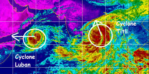
The post-Monsoon cyclone season kick started on active note, with the first month itself witnessing twin cyclones simultaneously. While Cyclone Luban has kept Arabian Sea active, Bay of Bengal has also been dynamic with the arrival of Cyclone Titli.

All thanks to the active ITCZ (Inter Tropical Convergence Zone) has now also started shifting southwards towards the coast. This is the main generator behind the disturbances in the open waters. As per weathermen, Indian seas are the deadliest basins for the formation of severe cyclonic storms during this time of the year. Both the systems have been off shoot of this ITCZ only.

Besides this, MJO (Madden-Julian Oscillation) is also presiding in the close proximity of Indian Ocean and is likely to visit the Indian waters soon. This has also been providing favourable weather conditions for the enhancement of any cyclogenesis between October 6-12. Occurrence of two cyclonic storms simultaneously is not very rare but not impossible also.

Cyclone Luban had covered long sea travel and have been sustaining the strength of cyclonic storm for last five days. Despite the cold waters, Luban continued to intensify into a severe cyclonic storm.

In comparison to this, Cyclone Titli has a small sea travel and would sustain its strength for mere 36 hours only in view of approaching land mass.

According to weathermen, any system forming in Bay of Bengal in October would eventually head towards Indian Coast, while Arabian Sea offers a lot of options for the tropical storm, right from Yemen, Oman, Somalia to Pakistan or Gujarat.

Please Note: Any information picked from here must be attributed to skymetweather.com

Similar Articles

thumbnail image
March 20, Today Marks The Spring Equinox: Day-Night Duration Nearly Equal

The official transition from winter to spring, known as the SPRING EQUINOX, occurs today! It’s time when the Sun crosses the celestial equator precisely at 2:31 PM, delivering warmer, longer days to the Northern HemiSphere. As autumn arrives, the South enjoys colder evenings.

posted on:
thumbnail image
आज सूर्य करेगा भूमध्य रेखा पार, बसंत ऋतु की शुरुआत, दिन-रात की अवधि लगभग बराबर

आज, 20 मार्च 2025, बसंत विषुव (Spring Equinox 2025) का दिन है। सूर्य भूमध्य रेखा को पार करेगा, दिन बड़े और गर्म होंगे। उत्तर गोलार्ध में बसंत ऋतु की शुरुआत होगी, दक्षिण गोलार्ध में शरद ऋतु का आगमन होगा। वहीं, सितंबर में यह खगोलीय घटना फिर से होगी।

posted on:
thumbnail image
गर्मी का दायरा बढ़ा! ओडिशा, महाराष्ट्र, तेलंगाना और रायलसीमा में 40°C के पार तापमान, राहत की उम्मीद

देश में समय से पहले गर्मी असर बढ़ रहा है। ओडिशा, महाराष्ट्र, तेलंगाना, आंध्र प्रदेश में अभी तापमान से 40°C से ऊपर पहुंच गया है, जिस कारण इन राज्यों में भीषण गर्मी हो रही है। फरवरी 2025, पिछले 125 वर्षों में सबसे गर्म महीना रहा है। कई जगहों पर सामान्य से 6.4°C तक ज्यादा तापमान रिकॉर्ड हुआ है।

posted on:
thumbnail image
दिल्ली में बढ़ेगी गर्मी! शुष्क और तपता रहेगा वीकेंड, बारिश की संभावना हुई कम

दिल्ली में गर्मी बढ़ रही है, पिछले 3 दिनों में तापमान 4°C बढ़ा है। आज अधिकतम 34-35°C, न्यूनतम 17°C तक रह सकता है। मार्च अब तक लगभग शुष्क बना हुआ है, सिर्फ 2mm बारिश दर्ज हुई है। 26-28 मार्च को तापमान 40°C के करीब पहुंचने की संभावना है। वहीं,पश्चिमी विक्षोभ से मैदानी इलाकों में बारिश की संभावना नहीं है।

posted on: