Tropical Storm Wipha to merge with probable first Depression of the season around Aug 6

August 2, 2019 12:16 PM|

Tropical Storm Wipha

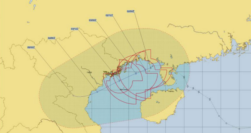
Tropical Storm Wipha, which was formed in the South China Sea between the Philippines and China won’t intensify much but is likely to bring the risk of flooding and locally damaging winds to the region in the coming days.

Wipha will now track west-northwestward near thecoast of China's Guangxi provincebefore tracking into northern Vietnam this weekend. Locations from southeastern China into northern Vietnam and northern Laos will need to be on alert for potential flooding downpours and a heightened risk for mudslides.

Rough seas will also be stirred and create dangers for boaters and swimmers across the Gulf of Tonkin into Saturday.

This weakened system is likely to reach the Bay of Bengal in the coming three days that is around August 5 where already aCyclonic Circulationwill be prevalent. As per our experts, around August 6 both these systems will merge and then form a Depression. This will possibly be thefirst Depression of this season.

During this time, the system will become more organised and will then move partly to theNorth Bay of Bengaland partly to West Bengal and Odisha. We can say that this system will have extensive coverage and good rains will be a sight over the West Bengal, Odisha adjoining Andhra Pradesh and Telangana.

As the system moves inland, rains will be seen over Chhattisgarh, North Jharkhand, and Madhya Pradesh. Along with this, rainfall will be seen in parts of Rajasthan, rains will be seen over the state along with parts of Delhi, Uttar Pradesh, Punjab, Haryana.

Subsequently, around August 10, it will reach the states of Gujarat and Rajasthan as well.

Image Credit: JTWC

Please Note: Any information picked from here must be attributed to skymetweather.com


Similar Articles

thumbnail image
March 20, Today Marks The Spring Equinox: Day-Night Duration Nearly Equal

The official transition from winter to spring, known as the SPRING EQUINOX, occurs today! It’s time when the Sun crosses the celestial equator precisely at 2:31 PM, delivering warmer, longer days to the Northern HemiSphere. As autumn arrives, the South enjoys colder evenings.

posted on:
thumbnail image
आज सूर्य करेगा भूमध्य रेखा पार, बसंत ऋतु की शुरुआत, दिन-रात की अवधि लगभग बराबर

आज, 20 मार्च 2025, बसंत विषुव (Spring Equinox 2025) का दिन है। सूर्य भूमध्य रेखा को पार करेगा, दिन बड़े और गर्म होंगे। उत्तर गोलार्ध में बसंत ऋतु की शुरुआत होगी, दक्षिण गोलार्ध में शरद ऋतु का आगमन होगा। वहीं, सितंबर में यह खगोलीय घटना फिर से होगी।

posted on:
thumbnail image
गर्मी का दायरा बढ़ा! ओडिशा, महाराष्ट्र, तेलंगाना और रायलसीमा में 40°C के पार तापमान, राहत की उम्मीद

देश में समय से पहले गर्मी असर बढ़ रहा है। ओडिशा, महाराष्ट्र, तेलंगाना, आंध्र प्रदेश में अभी तापमान से 40°C से ऊपर पहुंच गया है, जिस कारण इन राज्यों में भीषण गर्मी हो रही है। फरवरी 2025, पिछले 125 वर्षों में सबसे गर्म महीना रहा है। कई जगहों पर सामान्य से 6.4°C तक ज्यादा तापमान रिकॉर्ड हुआ है।

posted on:
thumbnail image
दिल्ली में बढ़ेगी गर्मी! शुष्क और तपता रहेगा वीकेंड, बारिश की संभावना हुई कम

दिल्ली में गर्मी बढ़ रही है, पिछले 3 दिनों में तापमान 4°C बढ़ा है। आज अधिकतम 34-35°C, न्यूनतम 17°C तक रह सकता है। मार्च अब तक लगभग शुष्क बना हुआ है, सिर्फ 2mm बारिश दर्ज हुई है। 26-28 मार्च को तापमान 40°C के करीब पहुंचने की संभावना है। वहीं,पश्चिमी विक्षोभ से मैदानी इलाकों में बारिश की संभावना नहीं है।

posted on: