Cyclone Pawan to head towards Somalia coast, high-velocity winds and good rains likely

December 3, 2019 4:00 PM|

Cyclone Soba

Cyclone Bulbulwas the last Cyclone which formed in the Indian seas on November 6. Now almost a month later another Cyclone is brewing in the Arabian Sea. In fact, according to Joint Typhoon Warning Center ( JTWC), it has already intensified into aCyclone Pawanwhich is centred 6.5 degrees North and 56.2 degrees East which is about 700 km south/southeast of Socotra Island.

However, the state-run meteorological department is yet to declare the same.

It was quick journey from Depression over Southwest Arabian Sea to a Deep Depression. Travelling in the favourable weather conditions, gradually the system is intensifying and is moving little northwestward. Later on, it will move westward and will head towardSomalia Coast. Presently the system is moderately supported by the environmental parameters wherein the wind shear is reasonable and Sea Surface Temperatures (SSTs) is also suitable for the system. Before making landfall, the system is expected to weaken as it is very likely to enter cooler waters and the wind shear will also go up. Despite weakening the system will result in high-velocity winds and good rainfall activities.

Cyclone Soba

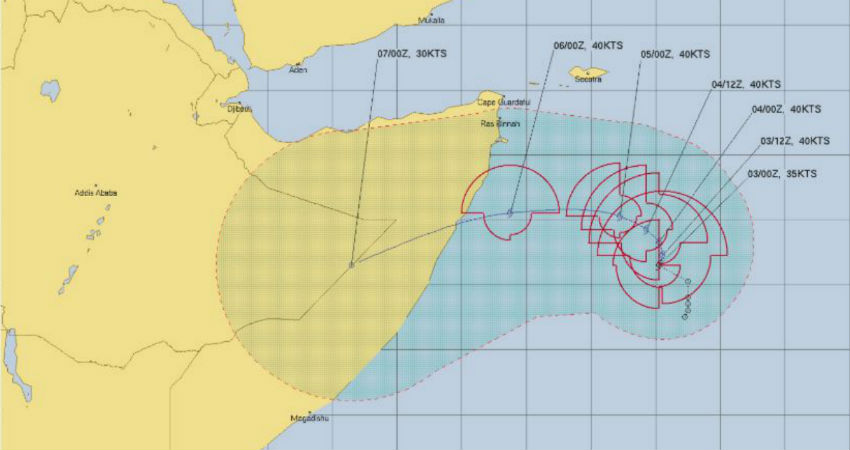
By December 6, the system will be in the close proximity of the coastline and by the evening of December 6 itself, it may make landfall.

The associated features like cloud bands are tightly wrapped around the system. However, there is a little poor agreement among the various models towards its track and intensity.

For the next 48 hours, it is very likely that the system will remain as aCyclone Pawanin the open waters.

Image Credits – JTWC/ CIMSS

Any information taken from here should be credited to Skymet Weather

Similar Articles

thumbnail image
March 20, Today Marks The Spring Equinox: Day-Night Duration Nearly Equal

The official transition from winter to spring, known as the SPRING EQUINOX, occurs today! It’s time when the Sun crosses the celestial equator precisely at 2:31 PM, delivering warmer, longer days to the Northern HemiSphere. As autumn arrives, the South enjoys colder evenings.

posted on:
thumbnail image
आज सूर्य करेगा भूमध्य रेखा पार, बसंत ऋतु की शुरुआत, दिन-रात की अवधि लगभग बराबर

आज, 20 मार्च 2025, बसंत विषुव (Spring Equinox 2025) का दिन है। सूर्य भूमध्य रेखा को पार करेगा, दिन बड़े और गर्म होंगे। उत्तर गोलार्ध में बसंत ऋतु की शुरुआत होगी, दक्षिण गोलार्ध में शरद ऋतु का आगमन होगा। वहीं, सितंबर में यह खगोलीय घटना फिर से होगी।

posted on:
thumbnail image
गर्मी का दायरा बढ़ा! ओडिशा, महाराष्ट्र, तेलंगाना और रायलसीमा में 40°C के पार तापमान, राहत की उम्मीद

देश में समय से पहले गर्मी असर बढ़ रहा है। ओडिशा, महाराष्ट्र, तेलंगाना, आंध्र प्रदेश में अभी तापमान से 40°C से ऊपर पहुंच गया है, जिस कारण इन राज्यों में भीषण गर्मी हो रही है। फरवरी 2025, पिछले 125 वर्षों में सबसे गर्म महीना रहा है। कई जगहों पर सामान्य से 6.4°C तक ज्यादा तापमान रिकॉर्ड हुआ है।

posted on:
thumbnail image
दिल्ली में बढ़ेगी गर्मी! शुष्क और तपता रहेगा वीकेंड, बारिश की संभावना हुई कम

दिल्ली में गर्मी बढ़ रही है, पिछले 3 दिनों में तापमान 4°C बढ़ा है। आज अधिकतम 34-35°C, न्यूनतम 17°C तक रह सकता है। मार्च अब तक लगभग शुष्क बना हुआ है, सिर्फ 2mm बारिश दर्ज हुई है। 26-28 मार्च को तापमान 40°C के करीब पहुंचने की संभावना है। वहीं,पश्चिमी विक्षोभ से मैदानी इलाकों में बारिश की संभावना नहीं है।

posted on: