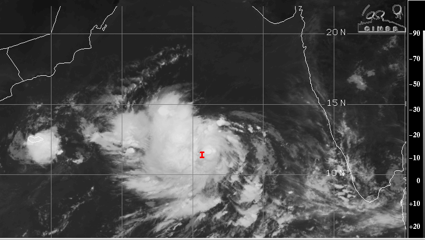
Yesterday’s low pressure area over Southeast Arabian Sea rapidly intensified in to a depression. It is centered around 11.6°N and 66°E, about 800km away from the coast and abeam Mangalore. Maiden weather system of this year in the Arabian Sea is located about 1100 km southwest of Mumbai. The depression has tracked nearly northward in the past 6 hr with an approximate speed of 10 kmh.

Depression in the Arabian Sea is having a broad and elongated low level cyclonic circulation. Also, the weather system is manifested in the satellite imagery with deep convective banding, tightly wrapped around the well marked center. The formative bands spiraling around the center suggest speedy intensification. The depression is expected to become tropical storm in the next 24hr. Depression is moving in favourable environmental conditions with very warm sea surface temperature and low vertical wind shear. The potential for developing in to a cyclonic storm in the next 24 hr is rather high. The first pre monsoon storm of the year in the Arabian Sea will be named ‘Biparjoy’ as suggested by Bangladesh. The weather system is likely to move northward keeping a safe distance from the coast for the next 24hr.
Tropical storm Biparjoy will be a slow moving system and is expected to reach abeam Mumbai on Saturday/ Sunday, remaining deep over the ocean waters. Though these storms are notorious for defying track and intensity, but it is likely to remain over open waters of Arabian Sea for the next 3 days. The tropical storm will be kept under close observation from hereon. Such monsters do have a history of threatening Gujarat Coast or recurve to scare Pakistan and Makran Coast.


