
A tropical storm is likely to form over the South China Sea shortly. The weather system will not have long sea travel. After the landfall, the storm is expected to weaken over North Vietnam and the adjoining Yunnan Plateau of China. The remnant of the system may continue moving westward and a weakened low pressure will find its way to the Northeast Bay of Bengal. Favourable environmental conditions may help to emerge of a significant monsoon system over the Indian Sea and activate monsoon surge over the eastern parts.
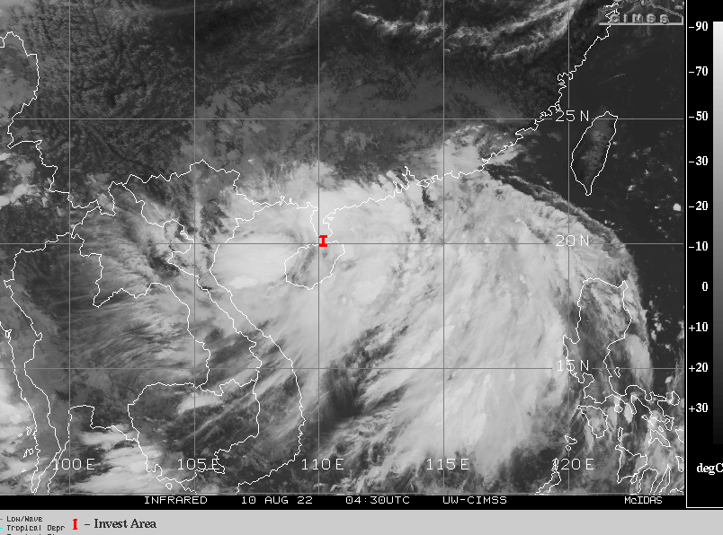
An invest area is presently located over the province of Hainan and the Gulf of Tongking in the South China Sea. Satellite imagery depicts a broad disorganized cluster of convective clouds. Though the environment analysis does not provide any distinct center of circulation but the support features suggest steady consolidation. Good outflow, weak vertical wind shear (15-20km/h) and warm sea surface temperatures (29-30°C) favour intensification to a tropical storm, albeit remaining weak due to proximity of land. Spiraling and few circular dense clouds are indicative of likely transformation to a warm core tropical cyclone in the next 24hour.
Typhoons and tropical storms in the West Pacific and South China Sea do have a history to travel across Southeast Asian counties and enter Bay of Bengal as a weak system . The monsoon depression over the Gulf of Tongking will be a named storm shortly. Thereafter, the storm is likely to make landfall over the coastline of North Vietnam and Southeast China, leaving limited sea travel. Weakened storm, as a depression first and low pressure area later, will move across northern parts of Laos and Thailand to reach central parts of Myanmar. Continuing further westward, low pressure or just a cyclonic circulation will emerge over Northeast Bay of Bengal, anytime between 13-14 August.
Favorable environmental conditions of North Bay of Bengal will support reorganization. Possibly, a well marked low pressure area or a depression is expected over Northwest Bay of Bengal, off Odisha and West Bengal coast on 14th/15thAugust. The weather system will be kept under observation and tracked closely for further prognostication.


