
Equatorial Pacific Ocean is heating up slowly and the Nino region indices are returning to neutral status. La Nina and El Nino are coupled ocean and atmospheric phenomenon. La Nina has weakened in the recent weeks and has reached near its end. Atmospheric indices are also easing out. Borderline La Nina conditions are fading away to make way for neutral ENSO.

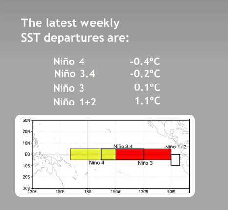
ENSO : Sea Surface Temperature (SST) anomaly for Nino 3.4 during Nov-Mar season was -0.82 Degree Celsius and it was -0.69 degree for the month of January2023 alone. In the most recent week (06March), anomaly has now reduced to -0.2 degree which is within the threshold limits of 'neutral'. Understandably, Oceanic Nino Index (ONI) has considerably weakened and ENSO is likely to turn neutral anytime soon.

Sub Surface Temperatures have started warming in the equatorial Pacific. It has expanded eastward to reach up to 130 Degree West. Cold SST anomalies have weakened in the Nino 1+2 region and overlapping area of Nino 3.4 and Nino 3 near equator between 80 Degree and 120 Degree West. Probability of ENSO neutral during March-May 2023 is 94%. El Nino conditions will become the most likely category around commencement of southwest monsoon over mainland.
IOD : The Indian Ocean Dipole is currently neutral. There has been a sharp rise in the SST during the last week. The IOD index value for the week ending 06March 2023 was +0.35 Degree Celsius. The index has turned 'warm neutral' since last week and sharply rose from the earlier mark of +0.16 degree on 26Feb 2023. IOD is projected to cross the threshold +VE of 0.4 degree around the onset of monsoon. Model results need to be treated with caution as the accuracy is considered low at this point of time.


MJO : Madden Julian Oscillation had strengthened during the 1st week of March. It moved rapidly and also increased the amplitude. It is expected to stay good as it propagates eastward across Western Hemisphere and Africa, during the week between 08th Mar and 15th Mar. It is likely to attenuate during the 2nd week between 15th and 22nd March, as it sails through phase 1&2, heading for Eastern Indian Ocean.
Earlier, courtesy active and strong MJO, cyclone Freddy sets world record for longest lived tropical storm overtaking previous record of 31days of hurricane John in 1994. Tropical storm Freddy made 3 landfalls and teetered for sometime on the brink of Cat-V hurricane. Equatorial belt of Indian Ocean on southern side of Arabian Sea and Bay of Bengal is likely to experience intense weather activity as the MJO traverse along the equator.

La Nina is likely to terminate very soon. Pacific Ocean will be transiting through the 'neutral' conditions before hosting El Nino. Neutral Pacific during spring will possibly enhance the accuracy of model forecasts. Though, El Nino invariably casts shadow on the Indian monsoon, but El Nino alone remain insufficient to conclude the event. The degree of confidence in the model forecasts increase when close to the event. However, sense of caution need to be exercised for a possible aberration in the Indian summer monsoon rainfall.
