 The wait for arrival of much awaited Southwest Monsoon 2018 has finally come to an end on Monday. As predicted by Skymet Weather, the Monsoon reached Kerala on May 28.
As per the weathermen, all the criteria required for the declaring the onset of monsoon over the Indian mainland have been met. The three main criteria of rainfall, wind field and outgoing longwave radiation (OLR) is all at place. Let us have a look at these criteria closely:
[yuzo_related]
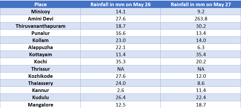
Rainfall:If after May 10, 60% of the pre-decided 14 stations such a Minicoy, Amini Devi, Thiruvananthapuram, Kannur, Punalur, Kollam, Alappuzha, Kottayam, Kochi, Thrissur, Kozhikode, Thalassery, Kannur, Kudulu and Mangalore report rainfall of 2.5 mm or more for two consecutive days, the onset over Kerala be declared on the second day provided the following criteria are also in concurrence.
The above mentioned have been met and that too not 60% but by over 90%. Following are the rainfall figures across the specified locations since last 48 hours:

Wind Field:Depth of westerlies should be maintained upto 600 hPa, in the box equator to latitude 10°N and longitude 55°E-80°E. The zonal wind speed over the area bounded by latitude 5°N to 10°N, longitude 70-80°E should be of the order of 15-20 KTS at 925 hPa. Sufficing this criteria, the wind speed is around 25 kmph- 30 kmph.
OLR:It should be below 200 wm-2 in the box confined by latitude 5°N to 10°N and longitude 70°E to 75°E. At present, the OLR value is around 160 wm-.

Ever since its arrival over Andaman and Nicobar Islands on May 25, Monsoon has been progressing at a steady pace. All thanks to the twin weather systems prevailing on either side of the Indian coast which have been responsible for pushing the Monsoon surge over the region.
A well-marked low pressure is seen in south-east Arabian Sea while a low pressure area is marked over Bay of Bengal. In fact, both the systems would help in taking the Monsoon even further, with the earlier one responsible for the progress of western arm of Monsoon, and the latter one for the eastern of Monsoon.
Particularly, the well-marked low pressure area in Arabian Sea would help the Monsoon surge to progress at a good pace along the West Coast in coming days. In fact, initial week of June would also see Monsoon covering parts of Northeast India.
Image Credit:en.wikipedia.org
Any information taken from here should be credited to skymetweather.com


