After the cessation of interminable La Nina, above-average sea surface temperatures(SSTs) have reclaimed the equatorial Pacific Ocean. El Nino ‘WATCH’ has been in place since March 2023 and El Nino ‘ADVISORY’ is expected to be issued soon. Global SSTs had earlier hit a record high during April when mercury levels rose at a pace never seen before. Ocean heating across the globe and the likelihood of a strong El Nino event appearing in the next few weeks may act in tandem to lead the coming year as Earth’s warmest on record.
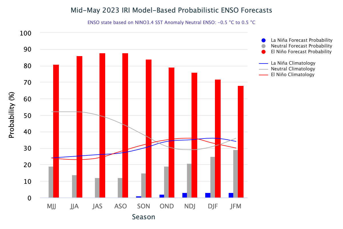
ENSO: El Nino is an ocean-atmosphere coupled phenomenon. It is rather difficult to dynamically understand the ocean and atmospheric state in isolation. While the ocean is leading the way to El Nino by adequate warming in the equatorial region, the atmosphere is a bit reluctant to tag along. The most recent 30-day SOI (Southern Oscillation Index) is -4.82. It appears to be a noisy index so far but now seems to be steadily moving towards the value of -8, which is considered the threshold value for El Nino conditions.
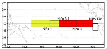

The complete Nino region is warmer than normal. Positive anomalies are stronger over the eastern and central parts of the Pacific Ocean hosting Nino 3 and Nino 1+2. The ONI (Oceanic Nino Index) is based on SST departures from the average in the Nino 3.4 region. This is the principal measure for monitoring, assessing and predicting ENSO. Nino 3.4 has also reached the threshold mark of + 0.5°C for the last 2 weeks. However, Nino 3.4 SST needs to stay >/= 0.5°C for the next several weeks to qualify for an El Nino event. El Nino conditions are considered to occur when the monthly Nino 3.4 SST departure meets or exceeds +0.5°C along with consistent atmospheric features. These anomalies must also be forecasted to persist for 3 consecutive months.
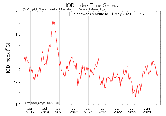
IOD: The Indian Ocean Dipole is currently neutral. The IOD index value for the week ending May 20, 2023, was -0.15°C, which is within neutral bounds (between -0.4°C and +0.4°C). IOD has remained -ve neutral for the 3rd consecutive week against the model predictions of +ve neutral. Monsoon onset is coming closer now and continuation of this trend may not prove beneficial. Unless reversed, -ve values of IOD may exacerbate El Nino’s drying effect. The majority of the models suggest a +ve IOD event in the coming months. However, this prediction has a rider of low model accuracy at this time of year.
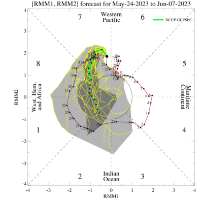
MJO: A moderately strong pulse of Madden Julian Oscillation has moved over the Western Pacific and triggered the basin with a super cyclone ‘Mawar’, ravaging Guam, Rota and the Mariana Islands in the Pacific. It is forecast to move into the central Pacific, albeit with a shrinking amplitude. Still, the West Pacific basin is likely to remain active till the first week of June. There is increased uncertainty with respect to the influence of MJO on the global tropical convective pattern during the subsequent week. Some of the models are inclined favourably for eastward propagation of MJO to reach the Indian Ocean between the 07th and 13th of June. If so, this may trigger and enhance monsoon activity over the Indian Seas during the onset phase.
Global average temperatures tend to be higher in El Nino years. A spike in global temperature over ocean and land leads to an uptick in extreme heat, hazardous tropical cyclones, and disturbing ecological balance posing a serious threat to mass mortality of delicate sea life, especially fish and coral reefs.


