

As of mid-October 2024, oceanic and atmospheric conditions across the tropical Pacific are indicative of ENSO-neutral conditions. Trade winds over the eastern equatorial Pacific were significantly weaker and therefore impeding the process of La Nina. Model forecasts initialized during October show a less pronounced evolution of La Nina, compared to the earlier forecast of Aug-Sep. Accordingly, borderline La Nina conditions are forecasted during Nov-Jan and Dec-Feb 2025. ENSO-Neutral conditions are likely to resume again during the second quarter of 2025.

ENSO: The most recent weekly average value of the Nino 3.4 index was -0.3°C. It was, once again, a near collapse from the previous weekly mark of -0.5°C. The index continues to struggle to reach/exceed the threshold mark of -0.5°C, where it needs to sustain for weeks together to establish La Nina conditions. The colder waters have persisted in the central-eastern Pacific region. The flanks continue to be warmer than usual. All the Nino indices need to get aligned with typical La Nina conditions and manifest accordingly with a drop in SST anomalies across the entire equatorial Pacific in the Nino region.

The ENSO forecast graph consists of three components: La Nina, El Nino, and Neutral. The La Nina share at best is ranging between 70-75% and the rest is neutral in the winter months. The pattern reverses in the spring of 2025. El Nino component is almost zero throughout and barely makes its presence at the start of next summer's monsoon season. It corroborates that La Nina conditions are likely to be weak and short-lived. The set of dynamical models suggests the intensity of La Nina to range between -0.7°C to --0.8°C, whereas, the statistical models are not at all inclined for a La Nina event and average temperature anomaly stagnates at about -0.3°C.

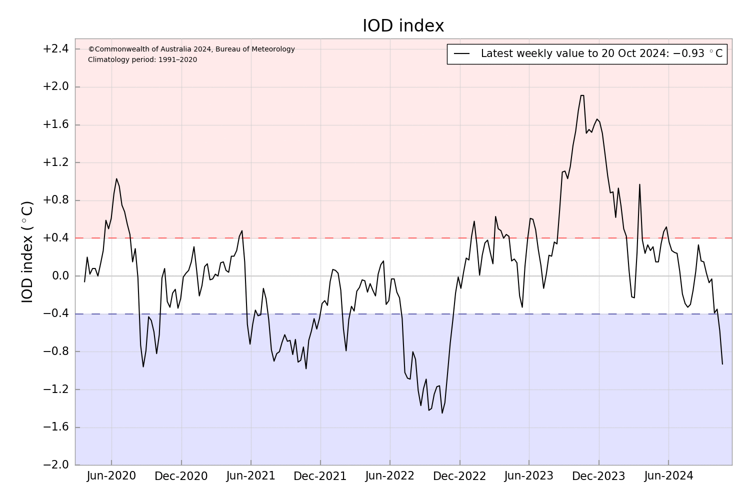
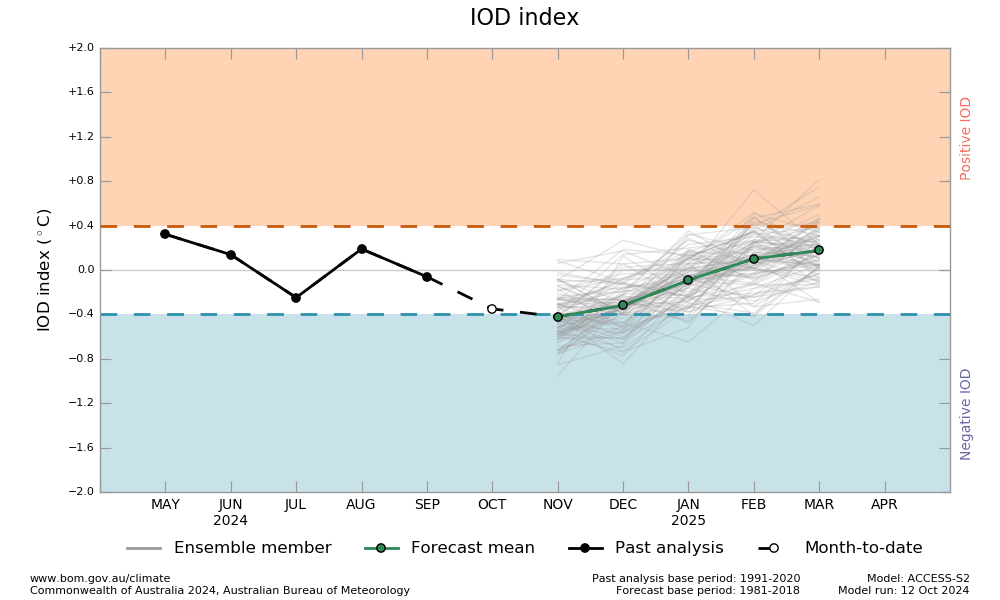
IOD: The Indian Ocean Dipole is neutral. The IOD index for the week ending 20 Oct 2024 was -0.93°C, the lowest since September 2022. For the second consecutive week, the IOD is negative and sufficiently below the negative neutral threshold. It seems to be reaching a point of no return and will remain negative throughout the autumn season (Oct-Nov 2024). The models indicate, that the IOD index will meet or exceed the negative IOD threshold in November, though this would not see the index sustained for a sufficient period to be considered a negative IOD event.
MJO: The Madden-Julian Oscillation pulse is fairly strong over the Maritime continent. It is likely to propagate eastward to reach the Western Pacific during the next week. In anticipation, the West Pacific has been quite active. Tropical storm Trami has already crossed the Philippines to enter the South China Sea. Further, it will move westward to strike the Vietnam-Laos coastline shortly. The positioning of MJO is favourable for cyclogenesis over the Bay of Bengal. Tropical cyclone Dana has commenced the post-monsoon season on a stormy note. Another storm may follow shortly over the Andaman Sea and the neighbourhood.

The sea surface temperature and sub-surface temperature anomalies vindicate the likely transition from ENSO-Neutral to La Nina. The Nino 3.4 index is generally suppressed and the value ranged between -0.1°C and -0.5°C during Sep-Oct 2025, still far from the quarterly index of -0.5°C or less needed for the event. Low-level wind anomalies over east-central and eastern equatorial Pacific also support the change. The recent weakening of trade winds continues to favour a weak La Nina event. A weaker La Nina implies a minimal impact on the conventional winter pattern.
