Severe Cyclone Burevi to strike Sri Lanka tonight, next hit Tamil Nadu on 4 December

December 3, 2020 8:00 AM|

Severe Cyclone Burevi

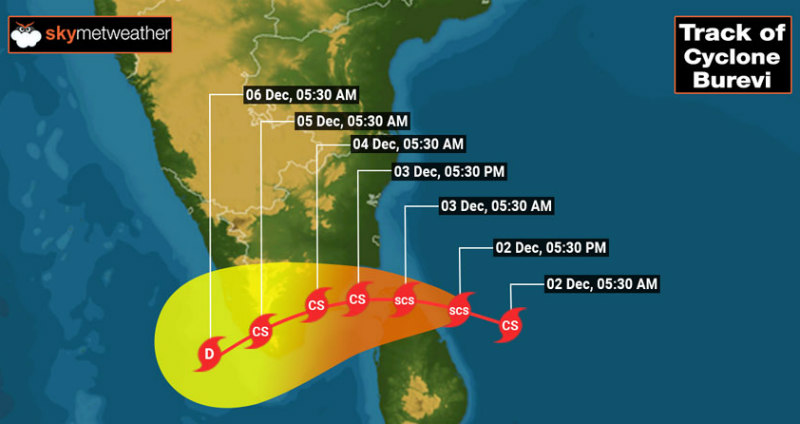
The deep depression in the Bay of Bengal intensified into a severe cyclonic storm Burevi and is now centred around 8.8°N and 83°E about 240km east-southeast of Trincomalee (Sri Lanka) and 450km east-southeast of Pamban (India). The storm has intensified further to a severe cyclonic storm, moving west-northwest and strike extreme North Sri Lanka near Mullaittivu (north of Trincomalee).

Severe Cycloe Burevi

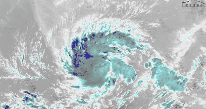
As inferred from the satellite images, the storm is rapidly organizing and strengthening steadily. It has developed a circular dense overcast cloud mass, a manifestation of its intensification in the past 6 hours. The cyclone will enter Gulf of Mannar on 3rd December morning and head for Tamil Nadu coast moving west-southwest. The system may weaken slightly to a cyclonic storm before making the second landfall over Tamil Nadu. It is expected to strike the coast near Tondi- Pamban- Tuticorin axis on 4th December morning and track towards the capital city of Kerala, Thiruvananthapuram.

Severe Cycloe Burevi

Heavy to very rains are likely over Sivaganga, Ramanathapuram, Thoothukudi, Tirunelveli, Pamban, Tondi and Kanyakumari with high-velocity winds. Also, incessant rains are expected over Kerala covering Thiruvananthapuram, Kollam, Kovalam, Alappuzha, Punalur, Kochi, and Alleppey. Lakshadweep Island will experience strong winds and very heavy rains between 04th and 06th December.

The storm will cause disruption of communication and connectivity. The uprooting of trees and collapse of weak and kutcha structures is quite likely. Evacuation from low lying and vulnerable areas is advised. Clearance of weather activity is expected from 06th December evening onwards.

Similar Articles

thumbnail image
March 20, Today Marks The Spring Equinox: Day-Night Duration Nearly Equal

The official transition from winter to spring, known as the SPRING EQUINOX, occurs today! It’s time when the Sun crosses the celestial equator precisely at 2:31 PM, delivering warmer, longer days to the Northern HemiSphere. As autumn arrives, the South enjoys colder evenings.

posted on:
thumbnail image
आज सूर्य करेगा भूमध्य रेखा पार, बसंत ऋतु की शुरुआत, दिन-रात की अवधि लगभग बराबर

आज, 20 मार्च 2025, बसंत विषुव (Spring Equinox 2025) का दिन है। सूर्य भूमध्य रेखा को पार करेगा, दिन बड़े और गर्म होंगे। उत्तर गोलार्ध में बसंत ऋतु की शुरुआत होगी, दक्षिण गोलार्ध में शरद ऋतु का आगमन होगा। वहीं, सितंबर में यह खगोलीय घटना फिर से होगी।

posted on:
thumbnail image
गर्मी का दायरा बढ़ा! ओडिशा, महाराष्ट्र, तेलंगाना और रायलसीमा में 40°C के पार तापमान, राहत की उम्मीद

देश में समय से पहले गर्मी असर बढ़ रहा है। ओडिशा, महाराष्ट्र, तेलंगाना, आंध्र प्रदेश में अभी तापमान से 40°C से ऊपर पहुंच गया है, जिस कारण इन राज्यों में भीषण गर्मी हो रही है। फरवरी 2025, पिछले 125 वर्षों में सबसे गर्म महीना रहा है। कई जगहों पर सामान्य से 6.4°C तक ज्यादा तापमान रिकॉर्ड हुआ है।

posted on:
thumbnail image
दिल्ली में बढ़ेगी गर्मी! शुष्क और तपता रहेगा वीकेंड, बारिश की संभावना हुई कम

दिल्ली में गर्मी बढ़ रही है, पिछले 3 दिनों में तापमान 4°C बढ़ा है। आज अधिकतम 34-35°C, न्यूनतम 17°C तक रह सकता है। मार्च अब तक लगभग शुष्क बना हुआ है, सिर्फ 2mm बारिश दर्ज हुई है। 26-28 मार्च को तापमान 40°C के करीब पहुंचने की संभावना है। वहीं,पश्चिमी विक्षोभ से मैदानी इलाकों में बारिश की संभावना नहीं है।

posted on: