Flooding situation in the foothills of Uttar Pradesh is expected to deteriorate more as the prediction of heavy rains is expected to continue in parts of the state for at least another 2-3 days. Moreover, as heavy rains in the Nepal hills are also continuing, much relief as of now from floods in Uttar Pradesh is not foreseen.
Light to moderate rains are going on and have occurred in the state in the last 24 hours. Within the span of 24 hours from 08:30 am on Sunday, Lucknow recorded good rains amounting to 28 mm, Bahraich and Gorakhpur both recorded 19 mm of rains each, while, light spells of 1 mm were witnessed by Varanasi.
[yuzo_related]
As per Skymet Weather, the reason for these rains can be attributed to the cyclonic circulation which was over Jharkhand and adjoining region. Moreover, the axis of Monsoon trough was also seen running along the foothills of the Himalayas that has led to these flooding rains. However, now this weather system has moved west northwestwards and is at present seen over the northern parts of Madhya and adjoining Uttar Pradesh.
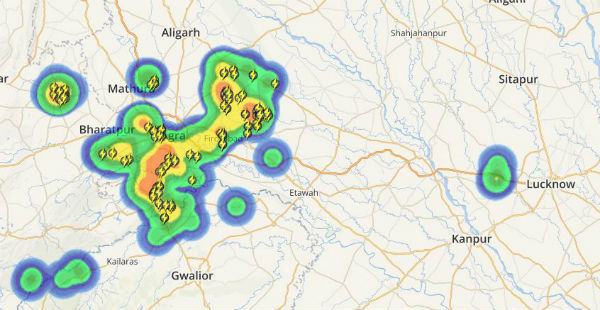
Click the image above to see the live lightning and thunderstorm across Uttar Pradesh
Moreover, the axis of Monsoon trough is also seen presently passing from Kapurthala towards Northeast Bay of Bengal across West Uttar Pradesh, Jharkhand, and West Bengal. Due to the oscillation of the trough slightly towards the south, rains are likely to increase in the western regions of Uttar Pradesh while will reduce in parts of East Uttar Pradesh.
Thus, districts such as Lucknow, Bareilly, Moradabad, and Agra including the adjoining belt of foothills such as Bahraich, Sitapur, Gonda can brace for some moderate to isolated heavy rains. While, the eastern parts of the state including districts such as Varanasi, Allahabad, and Gorakhpur can expect a rain reduction after 24-48 hours.
Such rains may further add on to the already flooding situation across foothills.
Image Credit: Newslocker.com
Any information taken from here should be credited to skymetweather.com


