
The state of Andhra Pradesh has a long coastline of about 600 km and it observes various shades of weather conditions since it comprises both land and coast. The coastal stations such as Kakinada, Visakhapatnam, Machilipatnam, and Kalingapatnam record maximum temperatures between 35°C and 36°C during this period. Meanwhile, the interiors districts of the state such as Kurnool, Anantapur, and Tirupathi record 40°C plus temperature.
[yuzo_related]
Telangana on the other side is a landlocked state which makes it prone for heatwave during the pre-Monsoon season. Thus, weather in Telangana is harsher in terms of heat as compared to that of Andhra Pradesh.
As per Skymet Weather, Southwest Monsoon made an onset on May 28. It has covered Kerala and parts of Karnataka. Within 10 days of Monsoons onset, it also covers Telangana and Andhra Pradesh. Thus, by June 6 with an error margin of +/ - 2 days, Southwest Monsoon is expected to set in over both Andhra Pradesh and Telangana. During the Monsoon season, the temperatures are also expected to witness a drop. In fact, the city of Nizams, Hyderabad is one of the most pleasant cities in terms of weather during the time of Monsoon.
Click the image below to see the live lightning and thunderstorm across Telangana and Andhra Pradesh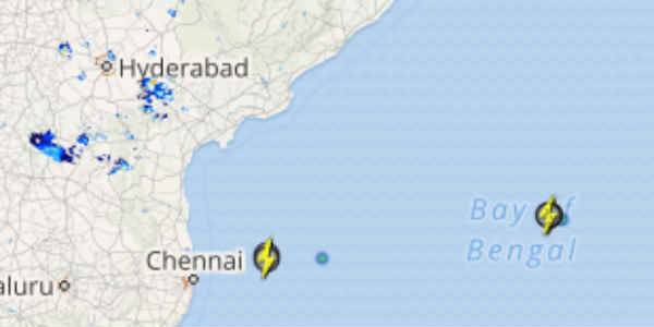
At present, Telangana and Hyderabad have been recording scattered pre-Monsoon rains in association with the trough which is extending from Madhya Pradesh to Telangana. Moreover, feeble cyclonic circulations which were close to the Andhra Pradesh coast resulted in rains.
In the last 24 hours from 8:30 am on Thursday,Hyderabadrecorded rain to the tune of 8.5 mm, Nellore 4.1 mm, Kalingapatnam 3.8 mm, Kakinada 2.6 mm, Anantapur 2.3 mm and Nizamabad 0.4 mm of rains.
Now, we expect that these scattered rains will continue over Telangana including Hyderabad and Andhra Pradesh until Monsoon sets in.
IMAGE CREDIT: Wikipedia.org
Any information taken from here should be credited to skymetweather.com


