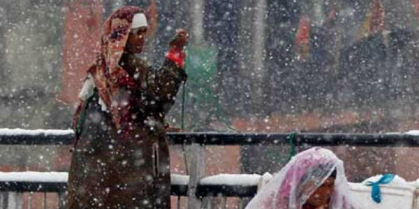
Rain and snow continue to lash the hilly states of North India, third consecutive day as well. Though, the intensity and spread of the rainfall and snowfall activity reduced in the last 24 hours in contrast with that observed a day before.
The reason for the continuous snow show over the hills of North India can be well associated with the arrival and passages of the active Western Disturbances over the Himalayan region. As per Skymet Weather, a fresh Western Disturbance approached the Western Himalayan region and began affecting Jammu and Kashmir from the night of February 10.
It gave a fair amount of rain and snow over parts of Jammu and Kashmir including a few regions of Himachal Pradesh. However, by February 12, the rainfall and snowfall activity began reducing in Jammu and Kashmir but continued over Himachal Pradesh and at isolated places of Uttarakhand.
[yuzo_related]
Thereafter, by February 13, the rain and snow show reduced over many parts of Jammu and Kashmir, but the remnants of the weather system continued to give rain and snow in parts of Himachal Pradesh.
In the last 24 hours from 08:30 am on Tuesday,Kullu, Nahan, and Shimla recorded 7.4 mm of rains each. Solan and Sundernagar also witnessed 4.2 mm and 1.6 mm of rains respectively.
Click here to get the live lightning and thunderstorm status across Northern hills
In fact,Manalihas been constantly recording season’s lowest maximums. From 3.6°C on Tuesday, the daytime high though scaled up marginally and settled at 4.2°C today.
As of now, the weather of the hills in North India is expected to start clearing up by today. Another fresh Western Disturbance which is over North Pakistan is likely to approach Jammu and Kashmir by February 15.
This weather system would once again bring rain in parts of Jammu and Kashmir, Himachal Pradesh and Uttarakhand along with snow over the upper reaches. The activity would start reducing by February 16, before the next Western Disturbance which is anticipated to approach by February 21 that would bring extended rain and snow over the northern hills.
ImageCredit: DNA India
Any information taken from here should be credited to skymetweather.com