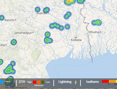
From past two days, rains have been drenching Kolkata thereby making the weather conditions pleasant. In fact, rains are pouring over the capital of West Bengal at present as well. These thundershowers have started blessing the city during the afternoon hours after the formation of convective clouds over the city.
On account of these thundershowers activities, the maximums over Kolkata have also dropped significantly. Thus, Kolkata saw a considerable drop in the daytime high which curtailed from 35°C at 1 pm to 26°C at 1:30 pm. This means a clear drop of 9 degrees in half an hour. At 3 pm also, the maximum of Kolkata was around 28°C.
Click the image above to see the live lightning and thunderstorm across West Bengal
As per Skymet Weather, these rains are expected to continue showing up in Kolkata but will be occasional in nature. At present these rains are scattered and localized as a trough is still seen running towards the south of Kolkata over Jharkhand and Odisha.
However, a cyclonic circulation is likely to develop over the North Bay of Bengal. Due to this, the trough will also move north towards Gangetic West Bengal. Thus, the combination of both these weather systems will result in an intensification of rains over Gangetic West Bengal including Kolkata around June 14.
This will in turn also result in the rains to pick up pace over the NMMT (Nagaland, Manipur, Mizoram, Tripura) region of Northeast India. Until these rains get intensified, on and off showers are expected to keep occurring over the region.
The normal date of onset of Monsoon over Gangetic West Bengal including Kolkata is around June 10. However, Skymet foresees Southwest Monsoon making an onset over the state also including Kolkata around June 14, that is a delay of 3-4 days.
[yuzo_related]
Image Credit: dnaindia.com
Any information taken from here should be credited to skymetweather.com


