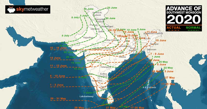
Until June 19, India monsoon is rain surplus by 30%. Northwest India is surplus by 1%. The monsoon has not yet reached North-Western parts of the country. But still, rains are at par. East and northeast India is also surplus by 8%. in northeast India Nagaland, Manipur, Mizoram, and Tripura are rain deficient whereas Assam, Meghalaya, and Arunachal Pradesh are in normal rain category. Eastern parts of the country are either in rain excess or in a large excess category.
South Peninsula is also rain surplus by 14%. Tamil Nadu and Lakshadweep are rain deficient in South India.
The best performer is Central India with an excess of 79%. In Central India, most of the metrological divisions are large rain surplus except Vidarbha and Orissa which are in excess rain category.
So far, the progress of monsoon in India is satisfactory. Monsoon has reached Gujarat and Eastern parts of Uttar Pradesh well before time. Now we expect monsoon to progress further in parts of Madhya Pradesh and Uttar Pradesh as well as in some parts of Uttarakhand in the next two days.
A trough is extending from central Pakistan to Gangetic West Bengal across Haryana, south Uttar Pradesh, and Jharkhand. Moreover, a cyclonic circulation is over southeast Uttar Pradesh, another cyclonic circulation is over the south Gujarat region. Easterly winds are blowing over the Indo Gangetic plains, and southwesterly winds from the Arabian Sea are feeding moisture over Gujarat and southeastern parts of Rajasthan. Therefore, we expect that monsoon will cover most parts of hills, Punjab, Haryana, Delhi, some parts of East Rajasthan and Gujarat by June 24 or 25th.
On and off rain, thundershower and dust storm activities are possible over parts of Rajasthan, Haryana, Delhi, and North Madhya Pradesh during the next 48 hours. Thereafter these thundershower activities will merge into monsoon rains as the monsoon will reach northwest India.


