El Nino conditions in the central-eastern equatorial Pacific remain strong with key oceanic and atmospheric variables consistently aligned for a perfect coupling. Low level easterly winds are weaker than normal near the International Date Line, while near normal over the eastern tropical Pacific Ocean. In the equatorial Pacific Ocean, sub-surface temperatures are also generally warmer than averages.

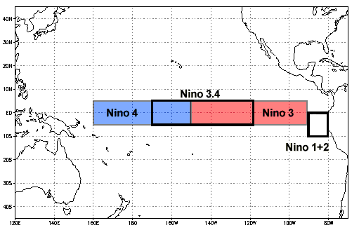
ENSO: Nino Indices are measured across vast areas of the Pacific Ocean. The equatorial stretch of 10°latitude (5°N-5°S) between 160°E to 80°W, through 180° measures about 12 million square kilometer. Nino 1+2 lies from equator to 10°S between 80°W-90°W. The temperature variation is seldom equally distributed across the stretch. The most commonly used region to assess the Oceanic Nino Index (ONI) is the Nino 3.4 region. Nino 4 region is more consistent in maintaining SST’s at or above the threshold value of 28°C, necessary condition for the development and persistence of deep convection in the tropics. It is easier for Nino 3.4 to have SST anomaly of +0.5°C and attain deep convection during the start of El Nino event, which invariably commences in Apr-Jun and reach maximum strength during Oct-Feb. However, during the peak time of El Nino, a larger anomaly of the SST will be required to achieve similar scale of deep convection. Accordingly, Nino 4 region is considered as a better choice for ascertaining La Nina as compared to Nino 3.4. An SST anomaly of -0.5°C in that region would be sufficient to bring water temperature below 28°C threshold and commensurate westward shift in the deep convection pattern in the tropical Pacific.


All the Nino Indices have consistently been warming except Nino 1+2, possibly due to the proximity of land. Nino 3.4, the representative of ONI has first time crossed 2°C since February 2016, after the super El Nino of 2015.

IOD: Indian Ocean Dipole, like El Nino, is a coupled ocean-atmosphere phenomenon. It is characterized by anomalous cooling of SST in the southeastern equatorial Indian Ocean and anomalous warming of SST in the western equatorial Indian Ocean. It is shown by several researchers that the IOD in the Indian Ocean can evolve without the ENSO forcing from the tropical Pacific. However, some researchers argue that on some occasions, ENSO can force the IOD. This complex relation between the ENSO and the IOD needs further confirmation. Like ENSO, IOD also significantly influences various climate signals.
The positive IOD event continues. It is currently tracking as a strong event, despite having marginal drop. The IOD index for the week ending 26Nov 2023 was 1.39°C, slightly lower than the last week mark of 1.49°C. This may be construed as start of the ‘break down’ process. But, looking at the strength of positive IOD event, normalcy may restore a little later than usual, this year.

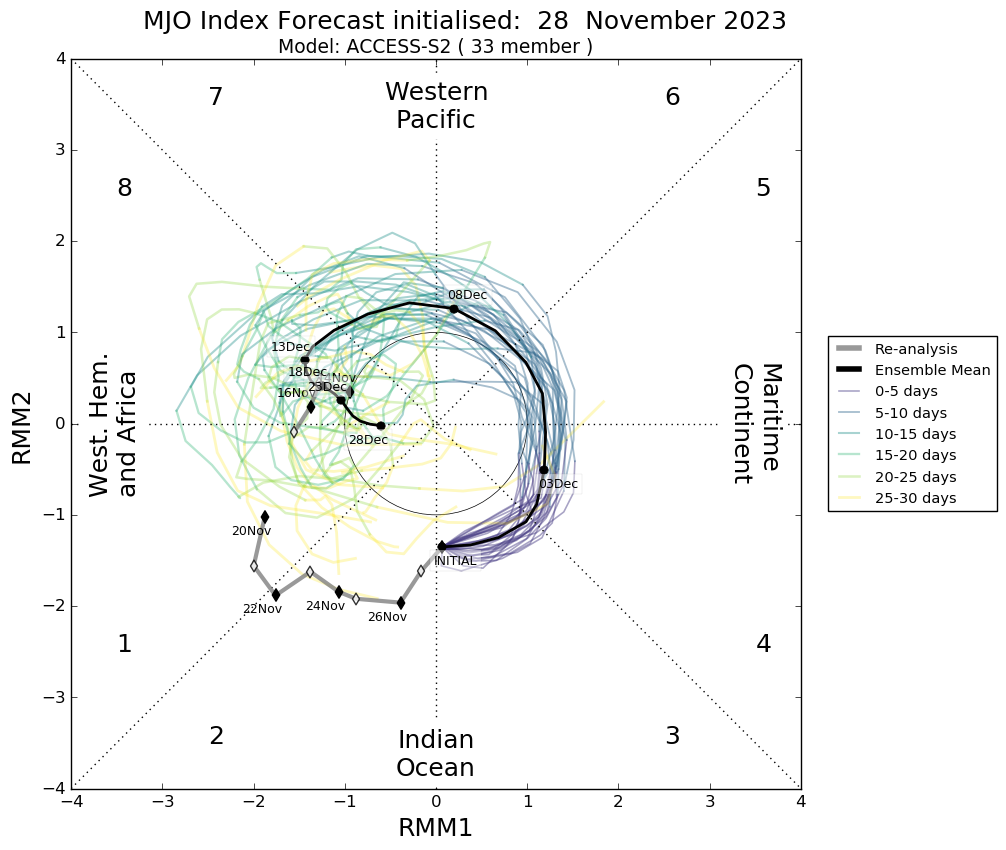
MJO: The Madden-Julian Oscillation, that has been mostly non-existent for the past several weeks has risen from the dead, over Bay of Bengal. It is expected to support cyclogenesis over Bay of Bengal till first week of December, before it travels far in the Maritime Continent with wincing amplitude. The Maritime Continent is a significant feature in the Earth’s climate system. An easterly trade wind along the ocean surface here creates a warm pool. This region, known as the Indo-Pacific warm pool persistently have a SST >/= 28°C and is often the warmest ocean region around the globe.
The trio of El Nino, IOD and MJO will keep the Indian basins active till first week of December. The formation of a cyclonic storm will disturb the monsoon streamline pattern. Restoration may take a few days to one week after the travel of the storm is complete. Therefore, northeast monsoon may remain in a lean phase over South Peninsula during 2nd week of December.


