Updated on August 1: The equatorial sea surface temperatures (SSTs) continue to be near-to-above average across most parts of the Pacific Ocean, especially Nino 3.4 that is a deciding factor for declaring El Niño. Here’s a look at the recent Nino Index (in °C):

In fact, Nino 3 and 3.4 has been seeing variations which means that fluctuations are observed in central parts of the Pacific Ocean. ENSO neutral conditions are prevailing currently and El Nino is likely to build up by fall of the year.
Updated on July 24: ENSO neutral conditions still persist and sea surface temperatures (SSTs) continue to be above average in the Pacific Ocean and are showing a warming trend.
The downward trend which was seen last week has been undone and most pockets are showing a warming trend only.

These figures are indicating towards an increase in percentage in ENSO which is progressively increasing indicating evolving El Niño conditions.
It is to be noted that evolving El Niño conditions are not considered to be a favourable one for good rains.
Published on July 20: ENSO neutral conditions are present in the Pacific Ocean. The equatorial sea surface temperatures (SSTs) continue to be near-to-above average across most parts of the Pacific Ocean, especially Niño 3.4 that is a deciding factor for declaring El Niño. Here’s a look at the recent Nino Index (in °C):

El Niño conditions are declared when the Oceanic Nino Index (ONI), which is three months running mean of SST (Sea Surface Temperatures) anomaly in the Nino 3.4 region, is more than or equal to 0.5°C for overlapping 3 months for five consecutive episodes. The most recent ONI figure i.e. for AMJ (April-May-June) stands at -0.1°C.
Niño indices have shown a dip as compared to the previous week readings but such marginal variation are commonly seen. Thus, for concrete conclusions, these indices need to be looked for a longer period of time.
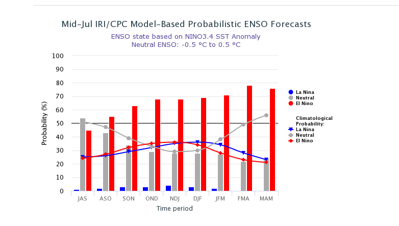
In fact, with the chance for El Niño which was around 50% two weeks before, has now again increased to about 65% during fall and to about 70% during winter 2018-19.
The average value of oceanic Niño Index (ONI) taken over a period of three months for the last four consecutive episodes are as follows:
![]()
The latest ENSO projection is as shown in the diagram below:

Image Credit:
Please Note: Any information picked from here must be attributed to skymetweather.com


