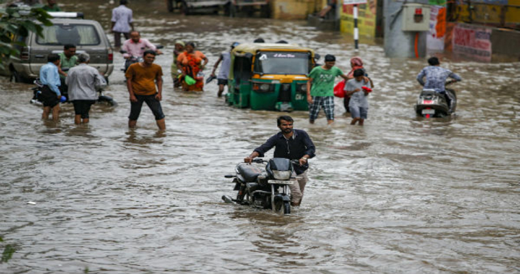
Incessant rains have lashed Rajasthan and Madhya Pradesh during fag end of July and beginning of August. For the last 3 consecutive days, parts of East Rajasthan and North Madhya Pradesh have been deluged with extremely heavy rains. The saturating rains have swept away some bridges, washed away many roads and overflowed few dams, reservoirs and lakes. The extended wet spell has severely debilitated the communication and connectivity.
The ‘land of kings’ as it is called, the state of Rajasthan has a very diversified and fertile land on the eastern side with an elevation of 100-300 mtrs. Contiguous to this division is Bundelkhand and Chambal region of Madhya Pradesh having varied elevated terrain with criss-cross rivers and dense forests. This entire region has been battered with submerging rains literally changing landmass in to waterways. The most devastated locations include Bundi, Kota, Sawai Madhopur, Datia, Guna, Sheopur, Shivpuri and Ashok Nagar.
Nearly 400-500mm of rainfall has been recorded at most of these locations in the last 3 days. Otherwise, moderate monsoon rainfall pockets have far exceeded their averages and went on to register record rainfall of the last decade.
Earlier, Datia, Guna and Sheopur measured 132mm, 107mm and 115mm rainfall in 24 hours and this scale is exceeded by Bundi, Kota and Sawai Madhopur which recorded 202mm, 158mm and 127mm yesterday. The saturated soil has been incapacitated to absorb anymore water and therefore inundation is likely to continue for few more days. Water bodies keep responding even after the rains recede due to diverse nature of catchment area and terrain peculiarity.
The remnant of well marked low pressure area, which earlier formed over Bay of Bengal, is now lying over Northwest Madhya Pradesh and neighborhood. This weather system has nearly remained quasi stationary over this area resulting inclement weather activity. The adverse weather conditions will continue to prevail, albeit with marginal relief, for the next 72 hours. Minor shift in the area of high impact weather activity is expected during this period.
The low pressure area is expected to weaken gradually and shift northward initially and later northeastward towards the foothills of Uttar Pradesh. This will drag the monsoon trough to north of its normal position closer to the foothills of Indo Gangetic plains in another 4-5 days. Heavy rainfall belt is going to shift accordingly and pose a renewed threat of overflowing Himalayan river down the mountainous region of Nepal, East Uttar Pradesh and Bihar.


