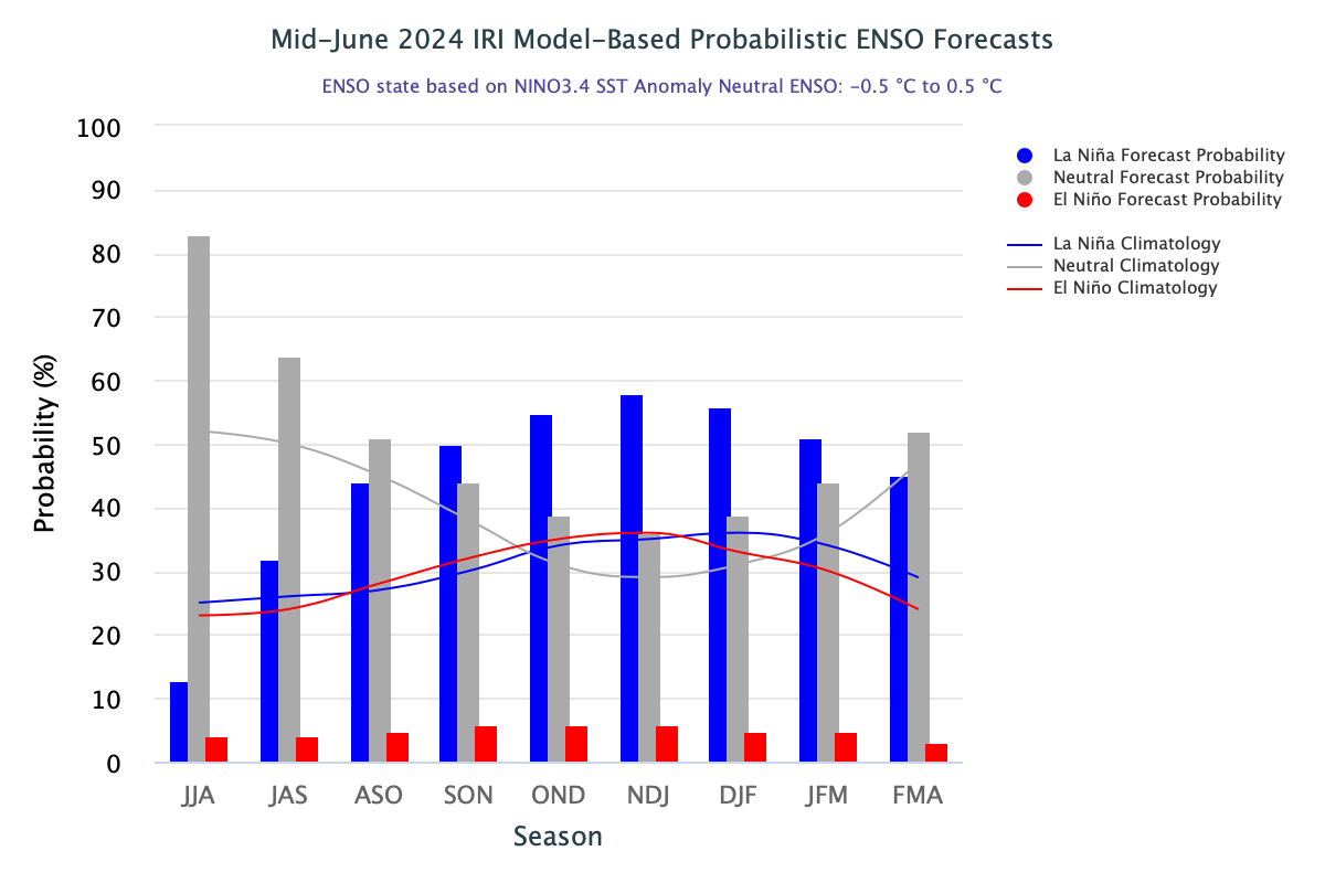
El Nino and La Nina are the periodic phenomenon occurring in the Pacific Ocean and play major role in altering the global weather and climate pattern. The Pacific Ocean has always remained more mysterious to decode sea surface and sub-surface temperature profile. The forecasting of Pacific Ocean developments is undertaken in a number of ways. Complex dynamical models project the evolution of the tropical Pacific Ocean from its currently observed state. Statistical forecasting models can also capture some of the precursors of such developments. Expert analysis may differ from the outcome of these models. The human forecasters may disagree to some degree with the models, which may have known biases. The forecasters use their own experience and judgement to apply course correction, when felt necessary. Therefore, the ENSO forecasts are a set of complex parameters and consequentially differ with the variability of initial conditions.

ENSO: Equatorial sea surface temperatures (SST’s) are above average in the West-Central Pacific Ocean, near average in the East-Central Pacific Ocean and below average in the far eastern Pacific Ocean. This is the normal profile of the ocean temperature during the transition from El Nino/La Nina to neutral conditions. The changes are more scrupulous during transition from El Nino to ENSO neutral, as is the case this season. The La Nina generally behaves soft and support dormant changes during the transition period.

Nino indices have marginally dropped across the region during the last week. However, the striking feature is that, Nino 3.4, the ONI indicator has turned zero-zero for the first time since 10April 2023. It may be construed that ENSO neutral may firm up now and become authentic during this month itself. Yet, the El Nino hangover remains even after the ENSO neutral is initiated. It gets completely subsumed when La Nina base becomes strong. Equatorial Pacific temperatures have to reverse across the entire Nino region to establish La Nina event. Nino 3.4 has to breach the threshold value of -0.5°C repeatedly for few weeks to ensure grounding of La Nina event.

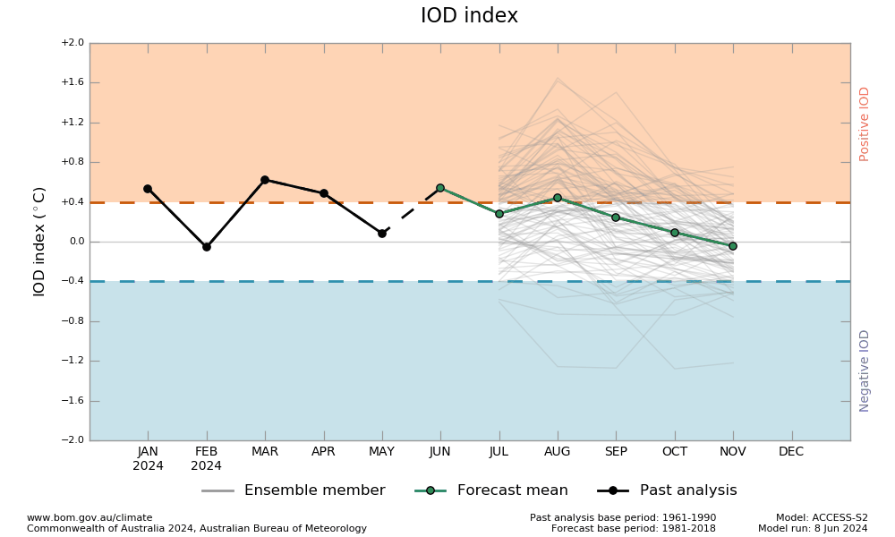
IOD: The Indian Ocean Dipole is currently neutral. The most recent 7 weeks have seen the IOD index within neutral threshold (-0.4 to +0.4°C). The IOD index for the last 2 weeks was nearly zero-zero. The latest weekly IOD index was -0.06°C, as on 16June2024. The IOD is showing inclination to remain sub-zero and this tendency has increased during the last week. The models indicate, that this trend may continue for the next few weeks. The index may not even rise adequately above the threshold value during the monsoon season.

MJO: The Madden-Julian Oscillation has remained inactive during the month of June, so far. The index was residing in the unit circle with minimal amplitude. The models depict some reorganization across the Western Hemisphere and propagating to the Indian Ocean at the end of this month. Though the GEFS and ECMWF models indicate an uptick in the tropical cyclone development probabilities across the Bay of Bengal, but the arrival of the monsoon may restrict any such move over this area. However, the chances of monsoon low or depression cannot be ruled out during early part of July and consequentially strengthening of monsoon stream.

The seasonal rainfall has incurred a deficit of 17% over the first three weeks of June. No support should be counted from ENSO and IOD for an uptick in the monsoon activity. MJO is becoming marginally favourable for activating the monsoon pulse during last week of June. The monsoon progress may speed up and it could be a repeat of last year with before time coverage, reaching last posts of Rajasthan.


