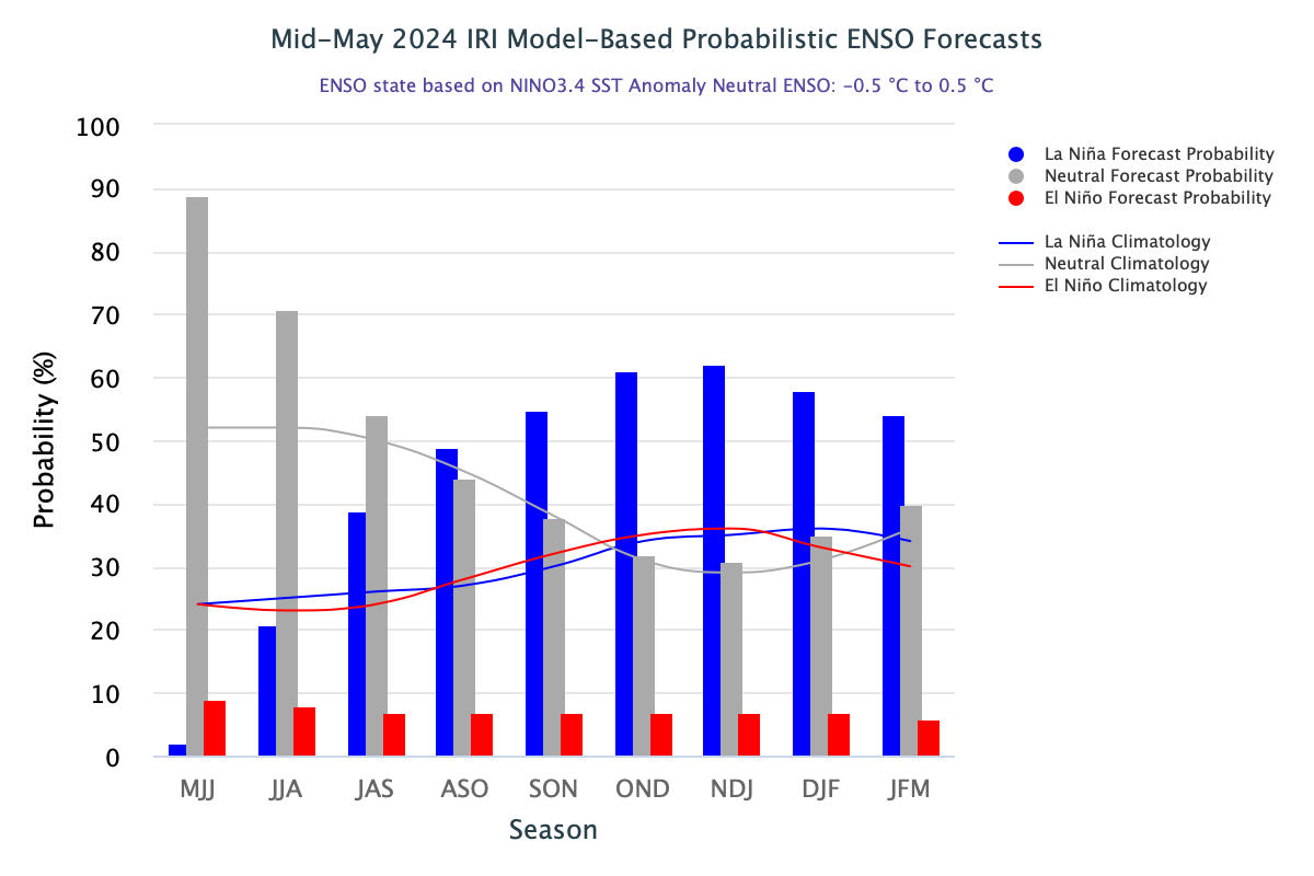
The 2023-24 El Nino event, which helped fuel a spike in global temperatures and extreme weather around the world, is now showing signs of ending. There is likely to be a swing back to La Nina conditions, later this year, according to a new update from the World Meteorological Organization (WMO). Latest forecasts from WMO Global Producing Center of Long Range Forecasts give equal chance (50%) of either ENSO neutral or a transition to La Nina during June-August 2024. The chances of La Nina conditions increases to 60% during July-September and 70% during August-November. The El Nino component during the period is likely to be neutralized completely and shared between ‘Neutral’ and La Nina, in the increasing order.
ENSO: La Nina is on its way. Large scale cooling of the ocean surface temperatures in the central and eastern equatorial Pacific Ocean, coupled with changes in the tropical atmosphere circulation, namely winds, pressure and rainfall is indicated, commencing anytime soon. The exact timings and duration still remain a contentious issue. The impact of La Nina event vary depending on its intensity, duration, time of the year when it develops, and the interaction with the other modes of climate variability.
Though, causes of ENSO interaction, irrespective of warm or cold event, is not fully understood, but the two components of ENSO - sea surface temperature and atmospheric pressure are strongly correlated. The strengthening and weakening of trade winds is a function of changes in the pressure gradient of the atmosphere over the tropical Pacific. The warming of sea surface tends to decrease the atmospheric pressure above it by transferring more heat in the atmosphere and making it more buoyant. In brief, it is a foregone conclusion that the pressure gradient affects the sea surface temperatures and the sea surface temperature affects the pressure gradient.

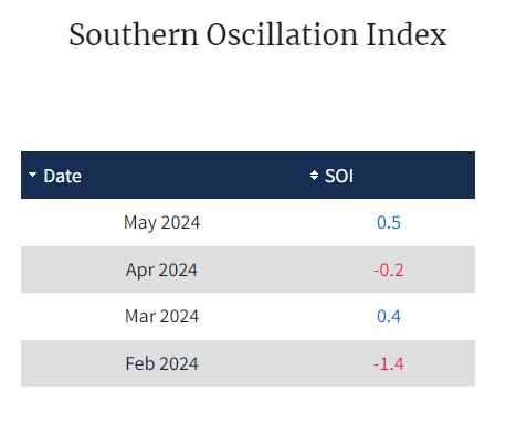
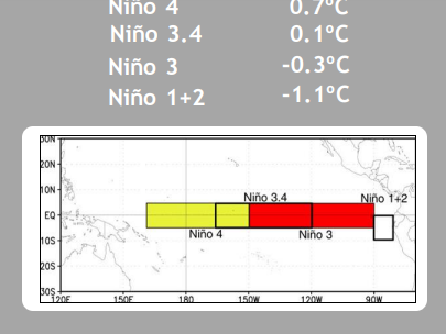
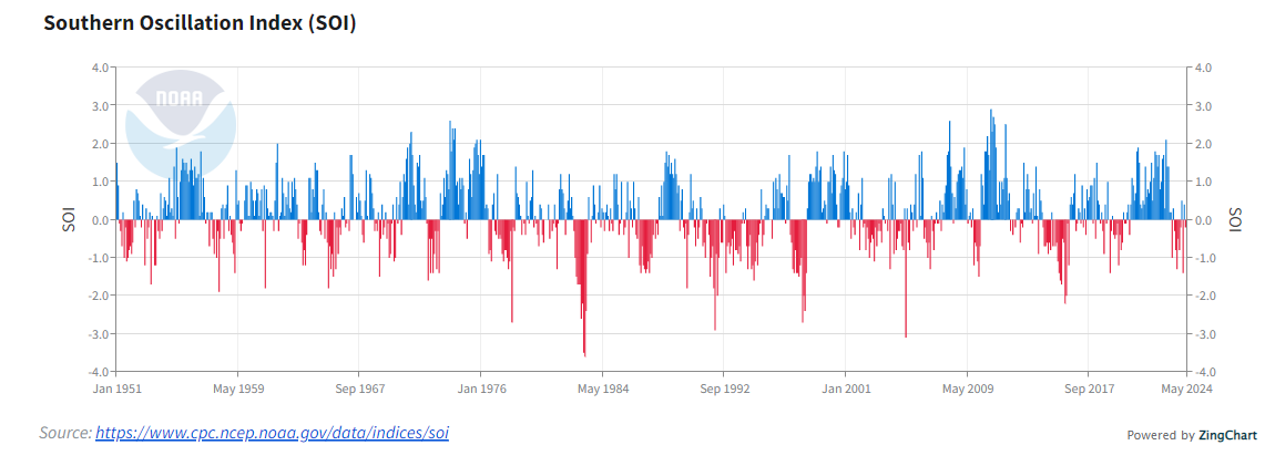
Over the last four weeks, there is miniscule changes in the indices across the Nino regions. Nino 3.4, the indicator of Oceanic Nino Index is crawling to reach zero-zero. The latest value of the index, as on 03rdJune 2024 was 0.1°C. Due to high specific gravity of water, the heat or cool is retained for longer duration. Southern Oscillation, is a coherent interannual fluctuation of atmospheric pressure over the tropical Indo-Pacific region. The Southern Oscillation is the atmospheric component of a single large scale coupled interaction called ENSO. The phase of the SO at a given point in time may be understood using the Southern Oscillation Index, which compares the difference in atmospheric pressure over Australia and Indonesia with that of the eastern South Pacific. The SOI has remained volatile this season, frequently switching from positive to negative and vice versa.
The index seems to have stabilized now and the average value for the month of May is +0.5. It also means that the response of the atmospheric arm of ENSO is withdrawn and EL Nino should make way for ‘neutral’ conditions during this month.
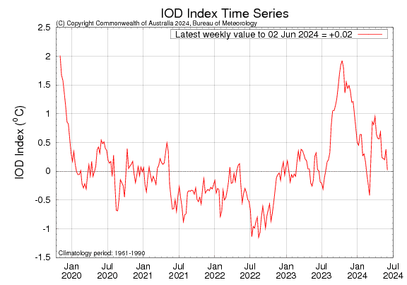
IOD: The Indian Ocean Dipole is currently neutral. The international climate models survey suggests a positive IOD event may develop in the coming months. The strength and duration of the event still remain somewhat obscured. The index is believed to have stable reads around this time but there are large fluctuations in the last four weeks. There has been a near collapse to zero-zero from its earlier mark of 0.38°C on 27May 2024. The latest weekly value of the index, as on 02June2024 was +0.02°C, the lowest in the last 13 weeks.
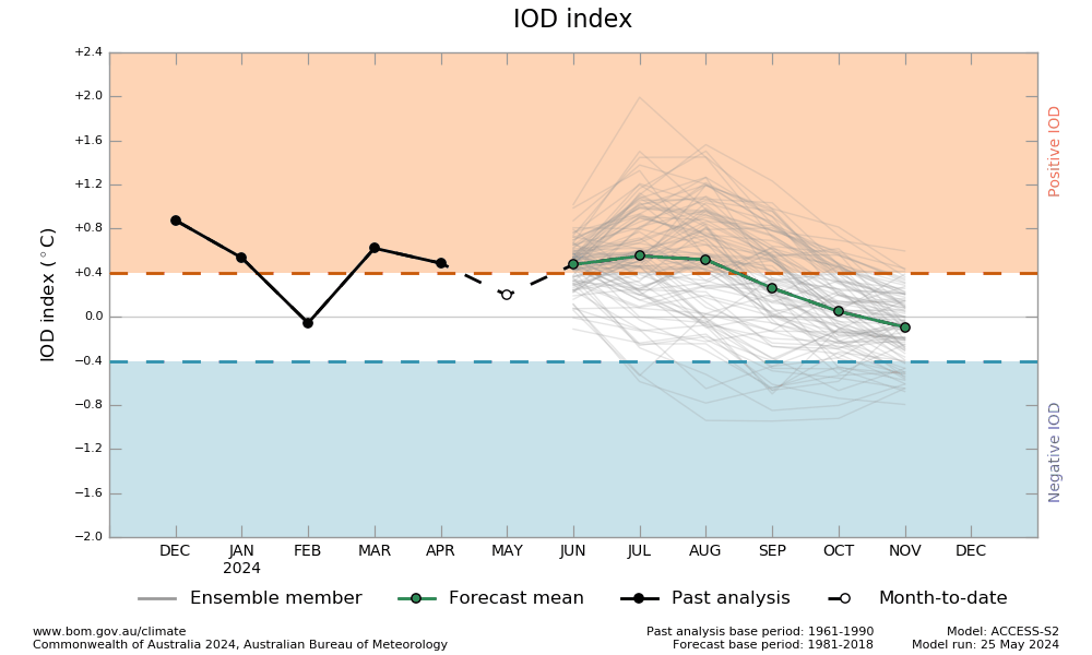
The latest model forecast indicates that intensity of the event seems to have diluted and it may not be a strong IOD event this monsoon season. The event usually starts around May-June, peaks between August and October and then rapidly decays when the monsoon arrives in the Southern Hemisphere, around the end of spring of Southern Hemisphere.
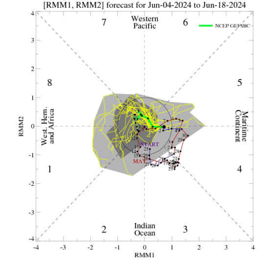
MJO: The Madden-Julian Oscillation signal which strengthened earlier, has quickly weakened over the first few days of June. The interference with the equatorial waves have apparently contributed to the sharp left turn in to the unit circle. The MJO signal is now nearing the West Pacific but the structure is predicted to remain incoherent, moving forward in time. The MJO forecasts generally depict weak activity over the next several weeks. The ECMWF indicate weak presentation of MJO signal, crossing over from Maritime Continent to Pacific during week-2 and the Western Hemisphere during week-3. This pattern may only support drier conditions across the Indian Ocean basins.
In the absence of MJO support, the Indian Seas may struggle to enhance the wet phase of the monsoon during 02nd and 03rd week of June. Formation of monsoon low pressure or depression is essential to take the eastern arm of monsoon further over Indo-Gangetic plains. As such, the NLM was stuck over Sikkim for nearly one week. The progress may remain sluggish and is feared to be a repeat of June last year.