
Cloud burst incidents during the monsoon season become rather frequent over the mountains of North India. Kashmir Valley, Kullu-Manali Valley and the Kumaon Hills are more vulnerable to devastating cloud bursts. The month of August and more so, the second half, is more susceptible to damaging eventualities on account of cloud bursts.
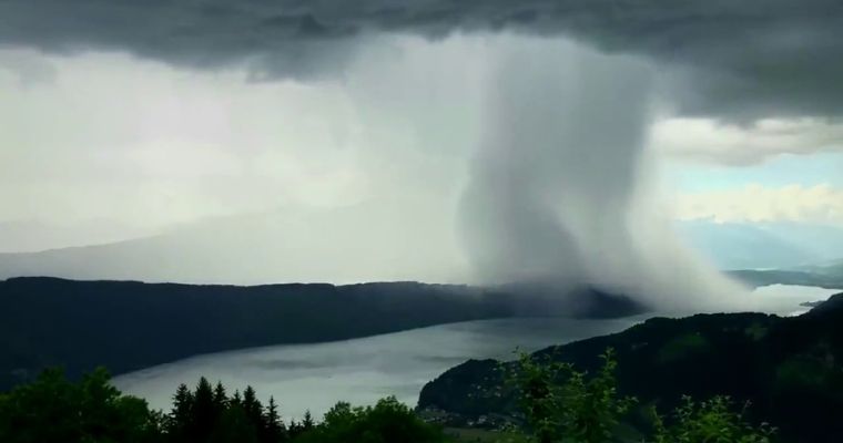
Cloud bursts are incidents of extremely heavy rain and thundershowers, nearly spontaneous and very short notice activity. Heavy downpour amounting to a rainfall rate of 100mm or more in one hour is the preliminary criterion for classifying the cloud bursts. Heavy rains in the catchment areas, draining down in large volumes with tremendous speed carry catastrophic potential. It is almost akin to the avalanche in the snowbound areas during the winter season.
The month of August is more prone to the ‘break-in-monsoon’ conditions. During the break monsoon, the seasonal monsoon trough shifts far to the north of its normal position and runs close to the foothills of the Himalayas. Actually, the monsoon trough is not traceable at all on many occasions and therefore presumed to be running parallel to the foothills of Himachal Pradesh, Uttarakhand, Nepal, Sikkim, Sub-Himalayan West Bengal and Assam Valley. Heavy to very heavy rainfall takes place in the foothills but not all along the stretch of the trough. Such a situation favours incidents of cloud burst over the mountains of North India.
The monsoon trough is likely to shift north of its normal position. To start with, from the plains of Punjab and Haryana, it will shift to the hill ranges of Pir Panjal, Dhauladhar, and Shivalik and further to the Himalayan ranges in Nepal. In the next few days, the trough will keep some distance from the foothills and run across the Indo-Gangetic plains. Around midweek and later, the upper air westerly trough will pull the western end to the north, in close proximity to the foothills. Rain and thundershower activity will increase over the low and mid-level mountains. Intense activity is to be watched out for any cloud burst-like situations between the 08th and 11th of August. Out of this, 10th and 11th Aug are more susceptible to severe activity. Conditions are likely to be favourable for another spell after 14th August 2024.
Image Courtesy: News18
