The climate cooling La Nina pattern was expected to develop in the Pacific Ocean, months ago. Earlier, worldwide weather agencies expected the event during the southwest monsoon but missed the date. There is no judicious explanation with anyone and the missing remains a mystery. The forecasters have shifted the timelines now, to November or later. The Bureau’s (BoM) model suggests SSTs to remain within the ENSO-Neutral threshold (-0.8°C to +0.8°C) throughout the forecast period to Feb 2025. But then, BoM standards for the ‘Oceanic Nino Index’ (ONI) are different from the Climate Prediction Center (CPC) and International Research Institute (IRI).

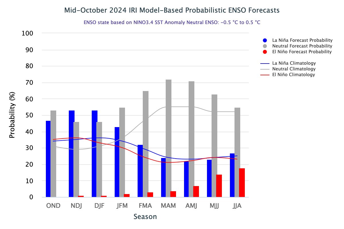
The latest North America Multi-Model Ensemble (NMME) forecasts are inclined towards warmer equatorial Pacific but still predict a weak La Nina. As a result of the weakening of equatorial trade winds, the IRI team still favours a weak event but has lowered the chances of La Nina. A weaker and shorter La Nina is less likely to impact conventional winters but may still influence the forecast guidance. Numerical models are good at catching the early signatures of strong La Nina events, but the model skills go poor, even within a lead time of 2-3 months, for weaker events.
ENSO: The predictability of ENSO has wavered this season, like never before. Unlike, other climate phenomena which can be difficult to predict even a few weeks prior, the ENSO prediction has a fair amount of reliability. However, the extremely slow transition from ENSO-Neutral to La Nina is lowering the confidence level, this time. Amid such a scenario, even the complete absence of La Nina or the shortest possible stint, during the winter months may remain a contingency.

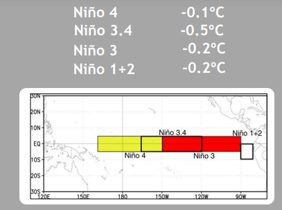
There is a simultaneous drop in temperature anomaly across the Nino region in the equatorial Pacific. Nino 3.4, the marker of ONI has touched the threshold value of -0.5°C for the third time in the last 6 weeks. As in the past, it has to be tested for consistency, for starting the La Nina episode. The average ONI for October 2024 works out to be -0.4°C, very close to the threshold mark. However, the flanks on either side continue to remain warm. This warming in the vicinity of the Nino 3.4 region will resist any abrupt change in the Nino 3.4 region.

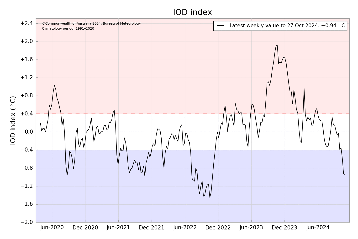
IOD: The latest Indian Ocean Dipole index value for the week ending 27th Oct 2024 was -0.94°C. This is the largest negative value since August 2022 and also, the fifth straight week of close to or below the negative threshold of -0.4°C. The IOD index seems to be slipping into the strongly negative domain. All the models corroborate that the index will meet or exceed the negative threshold in Nov-Dec 2024.

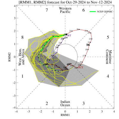
MJO: The Madden-Julian Oscillation is fairly strong in the Western Pacific. It is getting manifested as increased stormy activity in the region. Right now, there is a strong typhoon ‘Kong-Rey’ in the Philippines Sea and a tropical depression, a remnant of storm ‘Trami’ in the South China Sea. The MJO pulse will continue to move eastward and weaken slightly, as it reaches Western Hemisphere and Africa in Phases 8 & 1, over the next fortnight.
Evolving of La Nina continues to be controversial in terms of timelines and intensity. Earlier, the parameter deceived the southwest monsoon and now keeps the winters at tenterhooks. The impact of La Nina, on the winters of the Indian Sub-Continent, as expected earlier, is the least as of now. In any case, going by the past records, the correlation between La Nina and winter rainfall is not strong enough to impact conventional winters.


