Rains have remained unstoppable in Gujarat for the last many days now. During the last 48 hours, heavy to very heavy rains continued overSaurashtra and Kutchregion of Gujarat. While the eastern areas experienced light to moderate showers only in the past 24 hours.
At present, many parts of the state are experiencing heavy showers with overcast sky conditions. The strong winds are also continuing. All these weather conditions can be attributed to theWell Marked Low-Pressure Areaover the northern parts of Gujarat. This system has moved westwards in the last 24 hours and can be seen over northern parts of Saurashtra and Kutch at present.
The above system would be shifting further westwards, thus moving away from the Saurashtra and Kutch region. As a result of this movement, the rainfall activities would decrease significantly over the state.
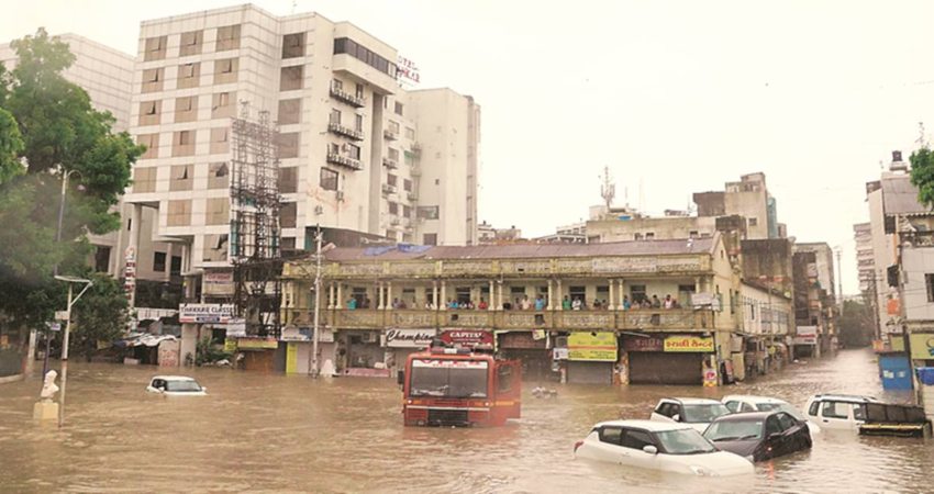
However, for at least next 12 to 18 hours, the Saurashtra and Kutch region will continue to experience intermittent spells of moderate to heavy rains. The heavy downpour has already caused havoc with many areas in the region undergoing through flood situation. Intense flooding has damaged agriculture as well.
Places like Bhuj, Naliya, Dwarka, Kandla,Rajkot,Porbandar, Jamnagar andAmreliwill get to see moderate to heavy rains for another 12 to 18 hours. And the flood situation will persist for the next 24 to 36 hours. Thereafter, the rainfall activities will decrease and as a result, the floodwaters will gradually start receding.
In the wake of heavy downpour, at least 19 people lost their lives in the state on Friday night. While due to incessant rains in Saurashtra and Central Gujarat region, 16 deaths due to wall/building collapse were reported on Saturday.
As on August 10, the Gujarat region is a rain surplus by 25%, while Saurashtra and Kutch are rain deficient by 2%. As more heavy showers are coming up, we expect both the region to come under the surplus category soon.
Image Credit: The Indian Express
Any information taken from here should be credited to Skymet Weather


