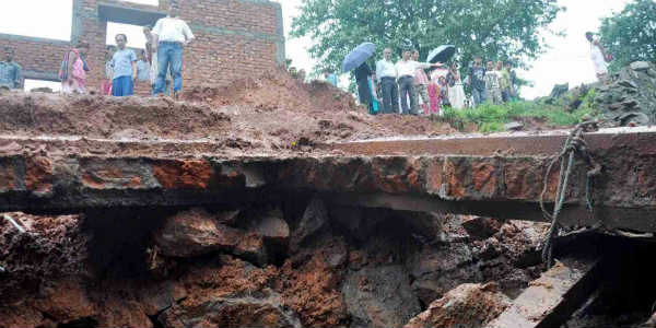
Southwest Monsoon has made a timely onset over Northeastern states. In fact, heavy to very heavy Monsoon rains have been recorded over several parts of the region in past 48 hours. These showers had caused massive floods and landslides in the states ofAssamandMeghalaya.
These weather activities can be attributed to the presence of a trough that extends over Northeast India. Besides this, humid winds from the Bay of Bengal are blowing over the region causing good rainfall.
[yuzo_related]
In a span of 24 hours from 8:30 am on Saturday, Silchar recorded a whopping 88 mm of rains, followed by Itanagar 63 mm, Agartala 53 mm, Tezpur 50 mm, Tinsukia 44 mm, Mazbat 49 mm, Pasighat and Kailashahar 46 mm, North Lakhimpur and Dibrugarh 42 mm of rains. There were many other areas that also recorded good Monsoon rain and thundershowers during the similar time frame.
As per Skymet Weather, the present situation is very conducive for more moderate to heavy rainfall over Northeast India, particularly over Arunachal Pradesh, Assam and Meghalaya. There are also possibilities of extremely heavy rainfall. Meanwhile, Nagaland, Mizoram, Manipur and Tripura will continue to record moderate with isolated heavy spells.
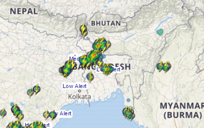
Click the image above to see the live lightning and thunderstorm across Northeast India
These relentless rains have triggered landslides across Meghalaya, with which six people have reported dead and several have injured. Rescue operations are underway as there many more people trapped under the debris. Similar condition is hovering in Assam; over 30,000 people have been affected by the massive floods. District administrations have opened 16 relief distribution help centers.
Image Credit: northeastnews
Any information taken from here should be credited to skymetweather.com


