Monsoon rains to continue over Konkan, Karnataka; to reduce over Kerala

July 5, 2018 4:23 PM|

kerala p

The West Coast of the country has been recording exceptionally good Monsoon rains for the last many days. Though the rains have reduced in both the spread and intensity in the last couple of days, the regions along the western coastal belt have not remained completely dry.

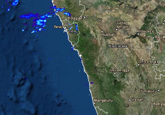
However, on the past day, rains over Kerala reduced though it continued over parts of Coastal Karnataka, Konkan, and Goa and Coastal Gujarat region.

In the last 24 hours, from 08:30 am on Wednesday,Valsadrecorded hefty three-digit rains to the tune of 158 mm, followed by Harnai with 138 mm of heavy rains, Alibag 95 mm,Dahanu84 mm,Mumbai’s Santa Cruz Observatory recorded 43 mm, Colaba 32 mm,Ratnagiri35 mm, Vengurla 18 mm, Panaji 30 mm,Karwar15.8 mm, Mangaluru 20.2 mm, Honavar 3.2 mm, Diu 2 mm and Cannur recorded 3 mm of rains.

[yuzo_related]

As per Skymet Weather, the reason for these rains can be credited to the offshore trough running along the West Coast. At present, the trough is extending from North Maharashtra to North Kerala coast. Moreover, a cyclonic circulation is also persisting over South Gujarat.

Capture

Click here to get the live lightning and thunderstorm status along the West Coast

Because of both the above-mentioned reasons, rains would continue along the West Coast, mainly over coastal Gujarat, Konkan, and Coastal Karnataka for another 24 to 48 hours. However, rains over Coastal Kerala may witness a slight reduction.

ImageCredit:  YouTube           

Any information taken from here should be credited to skymetweather.com 

Similar Articles

thumbnail image
March 20, Today Marks The Spring Equinox: Day-Night Duration Nearly Equal

The official transition from winter to spring, known as the SPRING EQUINOX, occurs today! It’s time when the Sun crosses the celestial equator precisely at 2:31 PM, delivering warmer, longer days to the Northern HemiSphere. As autumn arrives, the South enjoys colder evenings.

posted on:
thumbnail image
आज सूर्य करेगा भूमध्य रेखा पार, बसंत ऋतु की शुरुआत, दिन-रात की अवधि लगभग बराबर

आज, 20 मार्च 2025, बसंत विषुव (Spring Equinox 2025) का दिन है। सूर्य भूमध्य रेखा को पार करेगा, दिन बड़े और गर्म होंगे। उत्तर गोलार्ध में बसंत ऋतु की शुरुआत होगी, दक्षिण गोलार्ध में शरद ऋतु का आगमन होगा। वहीं, सितंबर में यह खगोलीय घटना फिर से होगी।

posted on:
thumbnail image
गर्मी का दायरा बढ़ा! ओडिशा, महाराष्ट्र, तेलंगाना और रायलसीमा में 40°C के पार तापमान, राहत की उम्मीद

देश में समय से पहले गर्मी असर बढ़ रहा है। ओडिशा, महाराष्ट्र, तेलंगाना, आंध्र प्रदेश में अभी तापमान से 40°C से ऊपर पहुंच गया है, जिस कारण इन राज्यों में भीषण गर्मी हो रही है। फरवरी 2025, पिछले 125 वर्षों में सबसे गर्म महीना रहा है। कई जगहों पर सामान्य से 6.4°C तक ज्यादा तापमान रिकॉर्ड हुआ है।

posted on:
thumbnail image
दिल्ली में बढ़ेगी गर्मी! शुष्क और तपता रहेगा वीकेंड, बारिश की संभावना हुई कम

दिल्ली में गर्मी बढ़ रही है, पिछले 3 दिनों में तापमान 4°C बढ़ा है। आज अधिकतम 34-35°C, न्यूनतम 17°C तक रह सकता है। मार्च अब तक लगभग शुष्क बना हुआ है, सिर्फ 2mm बारिश दर्ज हुई है। 26-28 मार्च को तापमान 40°C के करीब पहुंचने की संभावना है। वहीं,पश्चिमी विक्षोभ से मैदानी इलाकों में बारिश की संभावना नहीं है।

posted on: