The state of Madhya Pradesh is one of the biggest contributors to Monsoon rainfall. Meteorologically divided into two parts, generally, East MP observes more rains than West MP.
Throughout the Monsoon season, the weather systems keep making their way towards the central parts of the county. And while travelling, these systems remain more active and energetic over East MP, while they start losing their strength by the time they reach West MP.
Because of this reason, the average rainfall in East Madhya Pradesh for Monsoon season is 1051 mm, while for West Madhya Pradesh it is only 876 mm.
Talking about the Monsoon performance, the state has undergone a large variation in the amounts of rainfall within its two pockets (East and West MP) during the last 10 years.
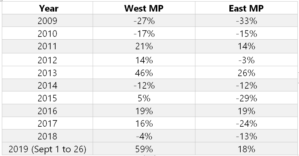
Monsoon performance in East and West Madhya Pradesh from 2009 to 2019 in percentage:

If we look at this data, then it is clearly visible that East MP has seen more and bigger failures than West MP in the last 10 years. Obviously, because the region’s average rainfall is higher than the other.
This Monsoon season, one after the other weather systems have been reaching Central India, because of which the state has been observing anexcessive amount of rainfall.
However, unlike other seasons, this time surprisingly West Madhya Pradesh has seen more rainfall than East Madhya Pradesh. Clearly, the Monsoon 2019 has revered its role over the state. So much so that, West Madhya Pradesh has observed 1345 mm of rain, as per the rainfall data from June 1 to September 26, thus standing rain excess at 59%, which happens to be the largest in the last 10 years.
Within the same time frame, East Madhya Pradesh has seen 1224 mm of rain so far, thus being rain excess by 18%.
Monsoon 2019 is going to end soon, but rains are still continuing with a good frequency and intensity in the state. During the next four days, rains would remain intact and for the next 48 hours, the state stands a chance of seeing fairly widespread rain and thundershower activities. Mainly moderate in intensity, isolated heavy spells cannot be ruled out.
These rains would be a result of mainly two weather systems, i.eLow-Pressure Area over the Arabian Sea and a Cyclonic Circulation over the Bay of Bengal.Both the systems would give good rains for another 48 hours in many parts of the state. Thereafter, rains would taper in the region and continue with lesser intensity until the Monsoon withdraws.
Image Credits – The Weather Channel
Any information taken from here should be credited to Skymet Weather


