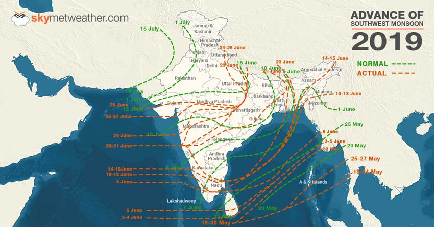
Updated on July 4, 2019: Southwest Monsoon has now covered entire Gujarat, Arabian Sea, Madhya Pradesh and more parts of Rajasthan. Now, theNorthern Limit of Monsoon(NLM) is passing through Barmer, Ajmer, Gwalior, Shahjahanpur, Najibabad, and Mandi.
Now, weather conditions have become favourable for theadvancement of Monsooninto rest of Rajasthan, Himachal Pradesh, Jammu & Kashmir, Uttar Pradesh and Uttarakhand and some more areas of Haryana, Chandigarh as well as Delhi during next 24 hours.
Updated on July 3, 2019: Southwest Monsoon has now advanced over more parts of Gujarat, Rajasthan, Madhya Pradesh and Uttar Pradesh. Now, the NLM is passing through the cities of Dwarka, Deesa, Udaipur, Kota, Gwalior, Shahjahanpur, Najibabad, and Mandi.
The persisting Well Marked Low will move west-northwestward and will result in Monsoon’s advancement over the leftover regions of Gujarat, Madhya Pradesh, more areas of Rajasthan, Himachal Pradesh, Jammu and Kashmir, rest of Uttar Pradesh, Uttarakhand and some parts of Haryana, Chandigarh and Delhi during next 48-72 hours.
Updated on July 1, 2019: The Northern Limit of Monsoon continues to pass through Dwarka, Ahmedabad, Bhopal, Jabalpur,
Pendra, Sultanpurar, Lakhimpur Kheri and Mukteshwar.
The Low-Pressure Area over North Coast of Odisha and adjoining Gangetic West Bengal will move inland and give moderate rains with few heavy spells are expected over Odisha, Chhattisgarh, many parts of Madhya Pradesh particularly southern and central districts of the state, Marathwada, Vidarbha, Konkan and Goa, Gujarat region and Coastal Karnataka.
Updated on June 30, 2019: Odisha and Chhattisgarh gear up for heavy rains in wake of Low Pressure Area in Bay
The Northern Limit of Monsoon (NLM) continues to pass through Dwarka, Ahmedabad, Bhopal, Jabalpur, Pendra, Sultanpur, Lakhimpur Kheri and Mukteshwar.
The low-pressure area is persisting over Northeast Bay of Bengal and adjoining areas. This system will continue to intensify and move in the west/northwest direction. This system is likely to become a depression in the next 48 hours.
This weather system will bring in heavy rains in the parts of Madhya Pradesh, Odisha, Chhattisgarh and Gangetic West Bengal during the next 24 hours.
Updated on June 29, 06:10 PM:Heavy rains halt Mumbai, intensity to reduce tomorrow onward
Vigorous Monsoon conditions have been lashing Mumbaiand nearby areas of Konkan & Goa coast since Thursday night. As predicted by Skymet Weather, rains of moderate with heavy spells have lashed Mumbai in the last 24 hours. The intensity was very good since yesterday evening till today morning. The Santa Cruz Observatory in Mumbai has recorded 69 mm of rains in a span of nine hours from 8:30 am to 17:30 pm.
Updated on June 28, 2:10 PM:Vigorous Monsoon gives heavy Mumbai rains, progresses further to Ahmedabad and Bhopal
Vigorous Monsoon conditions have been lashing Mumbai and nearby areas of Konkan & Goa coast since Thursday night. As predicted by Skymet Weather, rains of moderate intensity have been lashing Mumbai in last 24 hours. The intensity had increased significantly since morning, wherein the Santa Cruz Observatory in Mumbai has recorded 96 mm of rains in span of three hours from 8:30 am to 11:30 am.
Meanwhile, the western arm of Southwest Monsoon has progressed further into some more parts of north Arabian Sea, Gujarat and Madhya Pradesh. However, eastern arm remained stagnant.
The Northern Limit of Monsoon (NLM) is now extending through Latitude 22°N/Longitude 60°E, Latitude 22°N/Longitude 65°E, Dwarka,Ahmedabad,Bhopal, Jabalpur, Pendra, Sultanpur, Lakhimpur Kheri, Mukteshwar and Latitude 31°N/Longitude 80°E.
Updated on June 27, 3:40 PM: Heavy Monsoon rains likely over Konkan and Goa
During the last 24 hours, Monsoon has been vigorous over South Konkan and Goa, while it was active over Vidarbha, Assam, Meghalaya, Arunachal Pradesh, normal over Coastal Karnataka, Coastal Tamil Nadu, Coastal Andhra Pradesh,the rest of Northeast India, sub-Himalayan West Bengal, Sikkim and parts of East Madhya Pradesh.
The Northern Limit of Monsoon continues to pass through Veraval, Surat, Indore, Mandla, Pendra, Sultanpur, Lakhimpur Kheri and Mukteshwar.
Yesterday, Cherrapunji in Meghalaya recorded a whopping 292 mm of rains, Vengurla in Maharashtra saw 150 mm while Ratnagiri recorded 135 of rains.
During the next 24 hours, heavyMonsoon downpour is being expected to continue over Konkan and Goa.
Updated on June 26, 1:00 PM:Heavy Monsoon rains likely in parts of Assam and Meghalaya
During the last 24 hours, heavy Monsoon rains were witnessed in Assam, Sikkim and Sub-Himalayan West Bengal. Monsoon remained active over Andaman and Nicobar Islands, Kerala, Coastal Karnataka, South Konkan & Goa and Coastal Andhra Pradesh.
The Northern Limit of Monsoon continues to pass through Veraval, Surat, Indore, Mandla, Pendra, Sultanpur, Lakhimpur Kheri and Mukteshwar.
There has not been any major Monsoon progress in the last 24 hours.
Yesterday, Cherrapunji in Meghalaya recorded 159 mm of rain, followed by Goalpara 126 mm, Panjim 98 mm, Gangtok 83 mm and Cooch Behar received 77 mm.
During the next 24 hours,heavy Monsoon rains are likely over parts of Assam and Meghalaya. Coastal Karnataka, Kerala, Konkan & Goa and Gujarat will also witness active Monsoon conditions.
Updated on June 25, 1:00 PM: Monsoon reaches Mumbai, Surat and Indore, to trigger good rains
As predicted,Southwest Monsooncontinues to progress further for the sixth consecutive day. Monsoon 2019 has covered entire Maharashtra, SouthGujaratand some more parts of Madhya Pradesh. With the prolonged wait for Monsoon has come to an end for the major cities such aMumbai, Surat and Indore.
However, only western arm of theMonsoonmade the progress during the last 24 hours, but eastern arm remained stagnant.
The Northern Limit of Monsoon (NLM)is now passing through Latitude 21°N/Longitude 60°E, Latitude 21°N/Longitude 65°E, Veraval, Surat, Indore, Mandla, Pendra, Sultanpur, Lakhimpur Kheri, Mukteshwar and Latitude 31°N/Longitude 80°E.
With this, moderate to heavy rains like over parts of Konkan and Goa, Gujarat, West Madhya Pradesh, and Vidarbha in the next 24 hours.
Monsoon is likely to stay active to vigorous over Northeast India, bringing isolated heavy to very heavy and extremely heavy rains over Sub-Himalayan West Bengal & Sikkim, Assam, and Meghalaya. Widespread rains with isolated heavy to very heavy showers may lash rest of Northeast India.
Updated on June 24, 4:00 PM: Monsoon reaches Uttarakhand, next stop Mumbai and Gujarat
FreshMonsoonsurge has pushed it further into some more parts ofKonkan, most parts of Madhya Maharashtra and entire Vidarbha and Marathwada. It has also advanced further into Madhya Pradesh, Chhattisgarh, and Uttar Pradesh and has entered Uttarakhand.
TheNorthern Limit of Monsoon(NLM) is presently running through Latitude 18°N/Longitude 70°E, Alibagh, Malegaon, Khandwa, Chindwara, Mandla, Pendra, Sultanpur, Lakhimpur Kheri, Mukteshwar and Latitude 31°N/Longitude 80°E.
Conditions are favourable for Monsoon to cover remaining parts of entire Maharashtra including Mumbai andChhattisgarh, along with some more parts of Madhya Pradesh, Uttar Pradesh and Uttarakhand during the next 24-48 hours. Southwest Monsoon 2019 would also enter South Gujarat and Mumbai as well.
Updated on June 23, 3:00 PM: Monsoon covers more parts of Maharashtra and East Uttar Pradesh, next station Mumbai and Gujarat
Active Monsoon surge has further pushed the Monsoon 2019 further into more parts of the country. Southwest Monsoon 2019 has progressed further into some more parts of Madhya Maharashtra and Vidarbha and most parts of Marathwada. It has also progressed further into East Uttar Pradesh.
The Northern Limit of Monsoon (NLM) is now passing through Latitude 17°N/Longitude 60°E, Latitude 17°N/Longitude 70°E, Ratnagiri, Ahmednagar, Aurangabad, Nagpur, Pendra, Varanasi, Bahraich and Latitude 28.5°N/Longitude 81°E.
As a result, heavy to very heavy rains were seen over East Uttar Pradesh and Chhattisgarh, while moderate to heavy rains were seen over Kerala, Coastal Karnataka and isolated pockets of Andhra Pradesh.
In span of 24 hours from 8:30 am on Saturday, Ghazipur recorded 89 mm of rains, followed by Ambikapur 85 mm, Bahraich 59 mm, Jagdalpur 32 mm, Daltonganj 26 mm, Patna 31 mm, Gaya 30 mm, Tuni 34 mm, Kakinada 21 mm, Honavar 37 mm, Kochi 31 mm, Thrissur 26 mm, and Mangalore 24 mm.
Weather conditions are becoming conducive for further advancement of Monsoon and cover entire Maharashtra including Mumbai and Chhattisgarh and some more parts of East Uttar Pradesh during the next 48 hours.
Southwest Monsoon 2019 would also enter South Gujarat and East and Southeast Madhya Pradesh by June 25.
Updated on June 22, 2:00 PM: Monsoon advances further over Varanasi, Gorakhpur and Brahmapuri
The Northern Limit of Monsoon (NLM) is now passing through Ratnagiri, Sholapur, Adilabad, Brahmapuri, Pendra, Varanasi and Gorakhpur. Conditions are now becoming favorable for further advancement of Southwest Monsoon into the remaining parts of Central Arabian Sea, Konkan, Madhya Maharashtra, Marathwada, Vidarbha & Chhattisgarh, some parts of north Arabian Sea, South Gujarat andMadhya Pradeshand some more parts of East Uttar Pradesh during the next two to three days.
In the last 24 hours, Monsoon remained vigorous to active along the southern parts of West Coast, Bihar, Jharkhand, Chhattisgarh and Odisha. Active Monsoon conditions prevailed over the Northeast states, sub-Himalayan West Bengal, Sikkim, South Madhya Maharashtra, Karnataka and North Telangana. Monsoon remained subdued over eastern parts of Tamil Nadu while it remained normal over the rest parts.
The Monsoon islikely to advance further over some more parts of East Uttar Pradesh, Central Uttar Pradesh, East Madhya Pradesh, Vidarbha and Madhya Maharashtra.
Its likely to remain vigorous along Goa,Karnataka coastand Kerala, may enhance over east Uttar Pradesh, North Chhattisgarh, adjoining East Madhya Pradesh, North Madhya Maharashtra and over a few parts of Gujarat. Monsoon is likely to remain normal over Northeast states, West Bihar, Jharkhand, South Chhattisgarh and South Peninsula.
Coastal Tamil Nadu, parts of Gangetic West Bengal, Southeast Bihar and adjoining Jharkhand will see a subdued Monsoon.
Updated on June 21, 2:15 PM: Monsoon finally covers Andhra Pradesh, Telangana, parts of Chhattisgarh and Odisha
Southwest Monsoon 2019 has finally advanced into parts of South Madhya Maharashtra, most parts of Karnataka, remaining parts of Tamil Nadu, Puducherry & Karaikal, entire Andhra Pradesh, most parts of Telangana, some parts of south Chhattisgarh & Odisha, remaining parts of Bay of Bengal, most parts of West Bengal and some parts of Jharkhand and Bihar.
At present, the Northern Limit of Monsoon is passing through Ratnagiri, Sangli, Bijapur, Ramagundam, Jagdalpur, Phulbani, Jamshedpur, Asansol and Purnea.
Further, during the next few days, we expectSouthwest Monsoon to advanceinto remaining parts of Central Arabian Sea, Karnataka, Telangana, Konkan & Madhya Maharashtra, entire Marathwada, some parts of Vidarbha, remaining parts of Chhattisgarh.
Rainfall Alert:Heavy to very heavy rains are likely over isolated places of Chhattisgarh, Odisha and Coastal Karnataka. Heavy rainfall will occur over Coastal Andhra Pradesh, Telangana, Rayalaseema, Interior Karnataka, Tamil Nadu, Puducherry & Karaikal, Kerala & Mahe, Lakshadweep, Konkan & Goa, Jharkhand, Gangetic West Bengal and Assam & Meghalaya.
Updated on June 21, 1:20 PM: Monsoon to give heavy rains in Coastal Karnataka, Maharashtra, Konkan and Goa
ActiveMonsoon conditionswere observed over South Konkan & Goa, Karnataka, Kerala, Assam and Gangetic West Bengal. Normal Monsoon conditions were witnessed in Northeast India, Sub-Himalayan West Bengal and Sikkim. Meanwhile, Monsoon remained subdued in Tamil Nadu.
In the last 24 hours from 08:30 am on Thursday, Jorhat in Assam that saw 129 mm of rain, followed by Aminidivi 97 mm, Silchar 63 mm and Kannur 52 mm.
At present, the Northern Limit of Monsoon passes through Lat. 17°N/Long. 60°E, Lat. 17°N/Long. 70°E, Ratnagiri, Kolhapur, Shivamogga, Salem, Cuddalore, Lat. 16°N/Long. 86°E, Lat. 20°N/Long. 88°E, Kolkata, Lat. 25°N/Long. 89°E, Gangtok and Lat. 28°N/Long. 88°E.
Further, during the next 72 hours, conditions are becoming favourable for advancement ofSouthwest Monsooninto some more parts of Central Arabian Sea, Karnataka, Maharashtra, some parts of Andhra Pradesh, Telangana, remaining parts of Tamil Nadu, Bay of Bengal, some more parts of West Bengal & Sikkim, some parts of Bihar, Jharkhand and Odisha.
Updated on June 20, 1:10 PM:Monsoon reaches Maharashtra, heavy rains in Kerala, Coastal Karnataka, and Konkan & Goa to continue
ActiveMonsoonconditions had given heavy to very heavy rains along the West Coast, particularly over Konkan & Goa and Coastal Maharashtra. As a result,Monsoon 2019marked its arrival into Interior Karnataka, some parts of south Konkan & Goa, south Madhya Maharashtra, and some more parts of West Bengal including Kolkata, while it covered remaining parts of Coastal Karnataka and northeastern states
The Northern Limit of Monsoon (NLM) is presently passing through Latitude 17°N/Longitude 60°E, Latitude 17°N/Longitude 77°E, Ratnagiri, Kolhapur, Shimoga, Salem, Cuddalore, Latitude 16°N/Longitude 86°E, Latitude 20°N/Longitude 88°E, Kolkata, Latitude 25°N/Longitude 89°E, Gangtok and Latitude 28°N/Longitude 88°E.
For the next 24 hours, the activeMonsoon conditionswould continue to give heavy to very heavy rains over Coastal Karnataka and Konkan & Goa. Moderate to heavy rains would also see moderate to heavy rains over Kerala as well.
Updated on June 19, 10:10 AM:Active Monsoon gives heavy rains in Kerala and Coastal Karnataka, more in offing
Although the progress ofMonsoon 2019remained stagnant, but Monsoon surge remained active over Kerala, Coastal Karnataka and Andaman and Nicobar Islands. These pockets have recorded moderate to heavy showers, with one or two pocket even recording three-digit rainfall.
Active Monsoon conditions were also seen over parts of Assam.
In span of 24 hours from 8:30 am on Tuesday, Hut Bay recorded 108 mm of rains, followed by Port Blair 36 mm, Maya Bandar 26 mm. Cannur in Kerala saw 71 mm of rain, Kozhikode 49 mm, Karipur 35 mm, Honavar 43 mm,Mangalore35 mm, andKochi10 mm.
Meanwhile in Assam, Silchar saw 49 mm, Haflong 21 mm, and Lumding 18 mm.
However, Monsoon remained subdued over rest of the areas of Tamil Nadu and northeastern states.
Further, we expect moderate toheavy rainswould continue over Kerala and Coastal Karnataka during the next 24 hours on account of active Monsoon surge. Normal Monsoon conditions would be seen over northeastern states, with few pockets recording heavy rains.
Updated on June 18, 05:10 PM:Monsoon 2019 to advance further as low pressure to come up in Bay of Bengal
Southwest Monsoon has so far not seen any significant advancement at least on the Arabian Sea side. Moreover, on the Bay of Bengal side as well, Southwest Monsoon 2019 has only advanced until extreme northern parts of Bengal and Sikkim and East India is still devoid of Monsoon rains.
Now, with an upcoming low-pressure area in Bay around June 20, Monsoon is likely to advance further. Under the influence of this system, Southwest Monsoon 2019 may see an advancement into some more parts of Central Arabian Sea, Karnataka, some parts of south Konkan & Goa including Mumbai, Andhra Pradesh, rest of Tamil Nadu, some more parts of West Bay, rest of Northeast India, Sub Himalayan West Bengal, Sikkim and some parts of Odisha in the next three to four days.
Updated on June 17, 12:10 PM:Monsoon soon to make an entry over Chhattisgarh and Odisha in the next few days
Chhattisgarh is gearing up for a rainy spell in the next 24 to 48 hours. Places like Jagdalpur, Rajnandgaon, Ambikapur, Bilaspur and Raipur will witness these weather activities.
Monsoon is expected to reach the southern districts of the Chhattisgarh within next three to four days.
Also, a Trough is passing across Odisha, due to which we expect rain intensity to increase, particularly, over South and Coastal Odisha, while scattered rains would continue for some more days over the interior parts.
On and off rainfall and thundershower activities are expected to continue for the next two to three days over the entire state.
Moreover, we expectMonsoon to make an entry in Odisha, within next two to three days due to the increasing intensity of rainfall activities over the state.
Updated on June 16, 04:40 PM:Monsoon to advance further over parts of Karnataka, rest of Northeast India, more areas of Bengal
Southwest Monsoon has made more advancement towards the Bay of Bengal side with Monsoon reaching most parts of Northeast India, rest of Northeast Bay of Bengal, some more areas of Northwest Bay along with some regions of North West Bengal and Sikkim.
Now, the Northern Limit of Monsoon (NLM) is passing through Latitude 13°N/Longitude 60°E, Latitude 13°N/Longitude 70°E, through cities of Mangaluru, Mysuru, Salem, Cuddalore, Latitude 14°N/Longitude 86°E, through cities of Goalpara, Alipurduar, Gangtok and Latitude 28°N/Longitude 88°E.
Conditions are favourable for further advancement of Monsoon over more parts of Coastal Karnataka, rest of Northeast India, more areas of Bengal and Sikkim and some parts of Konkan and Goa during the next couple of days.
Updated on June 15, 12:00 PM:Monsoon to soon cover parts of Odisha, entire Northeast
Although Monsoon has advanced in some more parts of Northeast India in the last 24 hours, now conditions are favorable for the advancement ofMonsoon over almost all the Northeastern states. So, in the next 24 to 48 hours, we expect Monsoon to reach Sub-Himalayan West Bengal and Sikkim covering entire Northeastern states of Assam, Meghalaya, Nagaland, Manipur, Mizoram and Tripura. These on and off rain activities are likely to continue for at least next three to four days.
Also, back at Central India, the merging of south-westerly and northerly winds over Odisha and its adjoining areas combined with a Trough that is extending from Northeast India up to coastal Odisha are set to enhance rainfall activity in the state of Odisha for the next three to four days. So, we expectMonsoon to cover parts of Odishaparticularly South coastal Odisha in the next 24 to 48 hours.
Updated on June 14, 2:00 PM:Monsoon to advance further, to cover parts of Karnataka, Konkan and Goa
Southwest Monsoon 2019 continues to have a sluggish progress and has remained stationary since a long time now. By June 15, Monsoon covers at least two thirds of the country, however, until now, only 10 percent of the country has been able to see Monsoon showers.
Northeast India, which usually sees Monsoon making an onset in the beginning of June but this time, Monsoon has only reached until some parts of Mizoram and Manipur.
However, nowMonsoon is likely to progress further, covering Kerala, most parts of coastal Karnataka as well as over some parts of Konkan and Goa, during the next 24 to 48 hours. On the other side, Northeast India may also see arrival of Monsoon.
Updated on June 12, 1:00 PM: In the last 24 hours, the rain activities have increased significantly over West Coast all over Maharashtra, Karnataka toKerala. However, rain activities are still scanty over Interior Peninsula. Also, scatteredrain and thundershower activities are going on over Northeast India.
We now expect Monsoon to cover entire coastal Karnataka and parts of Konkan and Goa during the next 24 hours. Interior Peninsula and Northeast India, on the other hand, will have to wait for another two to three days for the onset.
However, due to the increase in rain intensity over Northeast India after 24 hours, Monsoon might make a progress over Northeast by June 14.
Updated on June 11, 6:00 PM: The wait for Mumbai Monsoon is going to end very soon as weather conditions are getting favorable for the onset of Monsoon here.
Cyclone Vayu is leading to continuous rains over the region.Mumbai is likely to witness Monsoon onsetby this weekend. This would be mean a delay in onset by a week as the normal date is June 10.
With cyclonic storm Vayu now abeam Mumbai, conditions remain very much favorable for more rains today also.
Updated on June 11, 5:00 PM: Light to moderate rains are continuing over parts of Kerala, and Karnataka today as well. Also, since the last few hours, rains are being witnessed over a few areas of Assam. These rains are further contributing to the onset of Monsoon over these areas. Already meteorologists at Skymet have forecast theonset of Monsoon in Karnataka and Northeast statesin the next 24 to 48 hours.
Updated on June 11, 12:00 pm: At present, the Northern Limit of Monsoon (NML) is still passing through Kannur, Madurai and via Southwest and East-central Bay of Bengal to Northeast Bay of Bengal up to Aisol. During the last 24 hours, moderate to heavy rains have occurred over Kerala, Coastal Karnataka and Andaman and Nicobar Islands. Light to moderaterains were seen over northeastern states, Sub-Himalayan West Bengal while Sikkim received extremely heavy rains at a few places.
Now, conditions are becoming favorable for the Monsoon to cover more parts of Kerala, South Karnataka, Tamil Nadu, andNortheast Indiaduring the next 48 hours.
Update on June 10, 02:30 PM:After a long wait,Southwest Monsoon has now reached some parts of Northeast Indiacovering many areas of Mizoram as well as Manipur. Southwest Monsoon has also arrived over rest of South Arabian Sea, Southeast Bay of Bengal, Lakshadweep, most parts of Kerala, more areas of Tamil Nadu, most parts of Southwest as well as East Central Bay, some areas of West Central Bay of Bengal.
Update on June 10, 1:00 PM:After the onset of Southwest Monsoon 2019 in Kerala yesterday, the rain intensity has significantly increased over both the states of Kerala and Karnataka. Many parts ofKerala saw heavy to very heavy rainsin the last 48 hours.
Also, there are chances of a Cyclone to soon form over the West Coast as a Low-Pressure Area has now intensified into a Depression. This Depression can soon form into a Cyclonic Storm in the next 24 to 48 hours. This will be named asCyclone Vayu.
Read in detail:Monsoon 2019 Forecast: Cyclone Vayu Likely Soon, Heavy Rains In Coastal Karnataka, Goa, Kerala
Update on June 09, 1:50 PM:Southwest Monsoon 2019 finally marked its onset over Kerala during the last 24 hours after a delay of almost one week. Now, conditions are also becoming favorable for the advancement ofSouthwest Monsooninto southern parts of Northeast India during the next 48 hours. Fairly widespread moderate to heavy rain and thundershower activities are occurring over parts of Kerala. We expect the rain deficiency of Kerala to go down or come near normal. In fact, in the wake of such widespread rains, the state may also become rain surplus in the coming one week.
Read in detail:Southwest Monsoon 2019 intensifies rains in Kerala, flood-like situation likely in coming days
Update on June 09, 12:30 PM:Conditions are becoming favourable for theadvancement of Southwest Monsoonin some parts of the northeastern states. Due to this situation, moderate to heavy rains occurred over Sikkim, Sub-Himalayan West Bengal, Upper Assam and Arunachal Pradesh. Light to moderate rains was observed over rest parts of northeastern states during the last 24 hours.
Read in detail:Heavy rains to lash northeastern states, Monsoon to advance in parts of Northeast India soon
Update on June 09, 11:00 AM:Southwest Monsoon 2019kick-started on a poor note, with rains on the lower side. In fact, the West Coast that is one of major contributor has remained silent so far. The onset of Monsoon was also a weak one, with only light rains with few moderate showers in sight over Kerala.
As a result, the first week of Monsoon ended with a whopping countrywide cumulative rain deficiency to the tune of 42%. From June 1 to June 7, the country recorded 13.9 mm of rains against the normal of 24 mm. Out of 36 sub-divisions, only 1 was largely deficient, 2 were excess, 5 were normal, but 11 were deficient, 15 were large deficient and 2 saw no rains at all.
Read in detail:Poor start for Monsoon 2019 as first weekends with 42 per cent rain deficiency, recovery not likely
Update on June 08, 4:20 PM:While on one side the system aligned all the features of Monsoon and finally pulling the Monsoon surge over Kerala, on the other hand, it would be the reason behind its sluggish advancement.
As the low-pressure area continues to get more marked, moist winds would now concentrate over the system. As a result, rains would reduce significantly reduce along the coast. Although, it would give some rains along with coastal areas of Kerala, Coastal Karnataka and Konkan & Goa, but would not be enough for furtheradvancement of Monsoon.
Update on June 08, 3:15 PM:After a long wait, and a delay of one week, Southwest Monsoon 2019 has finally made an onset over the state of Kerala. Weather conditions had started to become favourable for theonset of Monsoon in Keralafor the last couple of days.
Southwest Monsoonhas also arrived over parts of Lakshadweep, some parts of South Tamil Nadu and rest of Comorin-Maldives area. The Northern Limit of Monsoon (NLM) is currently passing through Latitude 11°N/ Longitude 60°E, Latitude 11°N/ Longitude 70°E, Amini Divi, Kochi, Madurai, Latitude 11°N/ Longitude 86°E, Latitude 16°N/ Longitude 91°E, and Latitude 20°N/ Longitude 94°E.
Conditions are favourable for furtheradvancement of Southwest Monsooninto remaining parts of South Arabian Sea, Lakshadweep area & Kerala, some more parts of Tamil Nadu, Southwest, Southeast, Eastcentral & Northeast Bay of Bengal and some parts of Central Arabian Sea and West-central Bay of Bengal during next 48 hours.
Conditions are also becoming favourable for theadvance of Southwest Monsooninto southern parts of Northeast India during next 48 hours.
JUST IN:#Monsoon2019has finally arrived over#Keralatoday after a delay of one week. Follow us for 24*7 updates on#Monsoonrains and its progress.
— SkymetWeather (@SkymetWeather)June 8, 2019
With a delay of 8 days, South West#Monsoonmade an onset over#Keralatoday. Heavy#rainsare possible over Kerala and#Karnatakacoast for next 4 -5 days. Monsoon progress will be sluggish in interior peninsula.@SkymetWeather@JATINSKYMET
— Mahesh Palawat (@Mpalawat)June 8, 2019
मॉनसून 2019: केरल में 8 जून को आगाज़ के साथ मॉनसून का भारत में चार महीनों का लंबा सफर शुरूhttps://t.co/drJXhe9hAi#MonsoonMadness2019#Monsoon#Monsoon2019#SouthwestMonsoon#SouthwestMonsoon2019#MonsoonForecast#MonsooninIndia#RaininKerala#Keralarains#Lakshadweep
— SkymetHindi (@SkymetHindi)June 8, 2019
मॉन्सूनची उत्तर सीमा अक्षांश 11 ° उत्तर / रेखांश 60 ° पूर्व, अक्षांश 11 ° उत्तर / रेखांश 70 ° पूर्व, अमिनी दिवी, कोची, मदुरई, अक्षांश 11 ° उत्तर / रेखांश 86 ° पूर्व, अक्षांश 16 ° उत्तर / रेखांश 9 6 ° पूर्व आणि अक्षांश 20 ° उत्तर / रेखांश 9 4 ° पूर्व ला पार करून जात आहे#Monsoonpic.twitter.com/CzxaQy5rAS
— Skymet Marathi (@SkymetMarathi)June 8, 2019


