
Updated on September 23, 2018 11:30 AM: Monsoon 2018: Daye becomes a well marked low, to give rains over North India
Cyclone Daye which gave torrential rains over many parts of the country has undergone several phases and has now weakened into a well-marked low-pressure area is now over East Rajasthan and adjoining Madhya Pradesh. The system will weaken further and move north northwestwards initially thereafter moving northwards. The system will interact with the Western Disturbance.
The system is now likely to weaken into a low-pressure area. Now, rains are likely to reduce over Madhya Pradesh, Gujarat and Southeast Rajasthan. Now, rains will increase over Northeast Rajasthan, West Uttar Pradesh, Punjab, Haryana, Delhi and the hills of North India.
Updated on September 22, 2018 7:30 AM: Monsoon 2018: Monsoon 2018: System weakens into Depression, low pressure area soon
The deep Depression over east Vidharbha and adjoining areas has finally weakened into a depression over the same region. It is presently centered at latitude 21.4°N and longitude 80.2°E, quite close to south of Gondia.
 The system would continue to track west-northwestwards and further weaken into a a well mark low pressure area during next 12-24 hours. By then it would over Madhya Pradesh and also start interacting with the fresh Western Disturbance over Jammu and Kashmir.
Along with parts of Maharashtra and Madhya Pradesh, rains would now also cover parts of East Rajasthan, Haryana, Punjab, Delhi-NCR and Uttar Pradesh. Also, under the influence of these systems, Uttarakhand and Himachal Pradesh would see some heavy to very heavy rains.
Updated on September 21, 2018 3 PM: Monsoon 2018: Deep depression continues to weaken over Central India; rains to cover most parts of country
The deep depression continues to travel across the eastern parts of the country. It is presently marked over Interior Odisha and adjoining Chhattisgarh, near latitude 20.5°N and longitude 82.5°E.
According to Skymet Weather, the system is moving at a fast pace in west-northwest direction. With lack of moisture incursion, the deep depression is losing its strength.
We expect that by Thursday evening it would weaken into a depression over parts of Madhya Pradesh. However, even as a weakened system, the rear of the system would continue to cover Odisha and West Bengal. They still have potential to give rains over most parts of Odisha and West Bengal during the next 24 hours. Heavy rains also cannot be ruled out over these areas.
During the next 24 hours, heavy rains would now focus over Chhattisgarh, Madhya Pradesh and North Maharashtra. In fact, under the influence of the system, wind pattern has already changed over the northwestern plains as well.
By Saturday, the system would further weaken and will be seen as a low pressure area over Madhya Pradesh. A trough would then form from the system up to a fresh Western Disturbance over Western Himalayas. As a result, it would bringing fairly widespread rain over Northwest India as well.
Updated on September 21, 2018 8 AM: Monsoon 2018: Cyclone Daye strikes Odisha, weakens into deep depression
As predicted, Cyclone Daye made landfall over South Odisha coast near Gopalpur around midnight. As expected, Daye weakened into a Deep Depression within six hours of striking the coast.
It is now presently seen as a deep depression over South Interior Odisha and adjoining areas. It is centered at latitude 20°N and longitude 83.7° E, arout 65 km eastsoutheast of Titlagarh, Odisha.
The system would continue to track west-northwestwards and loosening its strength gradually. We can expect it to become a depression by Friday evening. Heavy to very heavy rains have already lashed Odisha. Though weakened but the system would still give heavy showers over Odisha and adjoining areas of North Andhra Pradesh.
We can expect high velocity winds to the tune 40-50 kmph gusting to 65 kmph along and off Odisha and North Andhra Pradesh coasts during the next 12 hours. Sea condition will continue to remain rough to very rough along the East Coast, right from West Bengal to Andhra Pradesh for the next 24 hours.
Now, as the system would continue to move ahead in west-northwest direction, rain would now pick up pace over several parts of Telangana, Jharkhand and Gangetic West Bengal during next 48 hours. In fact, the effect of this could be seen over parts of adjoining peninsular India as well as northwest India by weekend.
Updated on September 20. 2018 9 PM: Monsoon 2018: Cyclone Daye forms in Bay, to strike Odisha coast by midnight
As expected, the deep depression in west-central Bay of Bengal has intensified into a cyclonic storm Daye. It is now seen over west-central and adjoining north-central Bay of Bengal.
The cyclone is presently centered at latitude 18.1°N and longitude 86.3°E, around 100 km southeast of Gopalpur, Odisha, around 160 km east of Kalingapatnam, Andhra Pradesh and 450 south-southwest of Kolkata, West Bengal. The system is moving at a good pace of around 24 kmph in west-northwest direction.
Cyclone Daye is likely to cross the Odisha coast near Gopalpur around midnight. Heavy rains and high velocity winds are already lashing coastal areas of Odisha and Andhra Pradesh.
We can expect rains to intensify further and some heavy to extremely heavy rains are now expected to lash Odisha and Coastal Andhra Pradesh tonight. At the time of landfall, wind speed would also increase to the tune of 80-90 kmph gusting up to 100 kmph. These would also be accompanied with some intense lightning strikes.
Gangetic West Bengal, Jharkhand, Chhattisgarh and Telangana would all see some heavy rains and thundershowers during the next 24 hours.
Cyclone Daye is likely to weaken within six hours of making the landfall. Initially it would weaken into a deep depression and further into a depression by tomorrow afternoon.
Updated on September 20. 2018 2 PM: Monsoon 2018: Cyclone threat in Bay, Odisha and Andhra on alert for torrential rains
Cyclone threat has been looming large over the East Coast of India. According to Skymet Weather, the deep depression in west-central Bay of Bengal is all set to intensify into a cyclonic storm shortly. If this happens, it would be named as ‘Daye’.
According to Skymet Weather, weather conditions are ripe for the formation of a cyclone in the Bay of Bengal. Sea surface temperatures are around presently around 29°C, which are extremely conducive for the strengthening of the weather system. Vertical wind shear is also low that further aides the system in getting more marked. Following image will help you understand better. 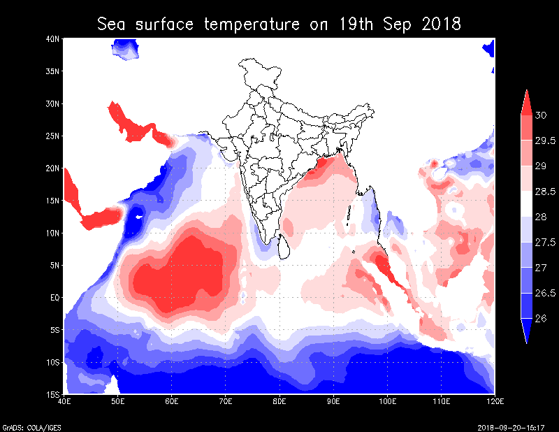 However, with less sea travel left, we expect this system to become a tropical storm for short duration.
The system is most likely to cross the Indian coast between Kalingaptanam, Andhra Pradesh and Puri, Odisha near Gopalpur by midnight as a cyclonic storm.
At present, the system is centered at latitude 17.6°N and longitude 86.8°E, around 280 km east-southeast of Kalingapatnam, Andhra Pradesh and about 265 km east-southeast of Gopalpur, Odisha.
In wake of this, both the coastal states have already been put on alert. Torrential Monsoon rains are likely to lash coastal areas of Odisha and Andhra Pradesh during the next 24 hours.
High velocity winds to the tune of 50-60 kmph can already be seen blowing along the coast. We can expect wind speed to even increase further to the tune 80-90 kmph at the time of landfall.
As per weathermen, torrential rains, squally winds and lightning strikes can be dangerous combination and could have some devastating results. We are afraid that all the three events could be witnessed tonight along Odisha-Andhra coast. In fact, parts of Gangetic West Bengal, Jharkhand and Chhattisgarh would also come in firing range of the system, bringing heavy rains.
The peripherals of the system would also give good rains over Rayalaseema, Telangana North Interior Karnataka and North coastal Tamil Nadu as well.
Sea conditions have already become rough to very rough off and along the entire East Coast. Fishermen and locals are advised not to venture out in the sea for the next 48 hours. However, as the systems crosses the coast, we expect it to weaken into a deep depression again. But even as the weakened system, it would be capable of giving torrential rains over most parts of the country.
By September 21, along with the above mentioned areas, rain belt would also start lashing East Madhya Pradesh, Maharashtra, and Bihar. Weathermen predict that rains would keep shifting with the system. Though rains would vacate Odisha and Andhra Pradesh by September 22, but at the same time rain would tighten grip over the central parts of the country that include entire Madhya Pradesh, Uttar Pradesh, and parts of Rajasthan and Gujarat.
By September 23 and 24, northwestern plains of Delhi, Punjab and Haryana would also start receiving rains. According to Skymet Weather, barring extreme southern parts of Southern Peninsula, the system would be responsible giving rains over the entire country.
Any information taken from here should be credited to skymetweather.com
