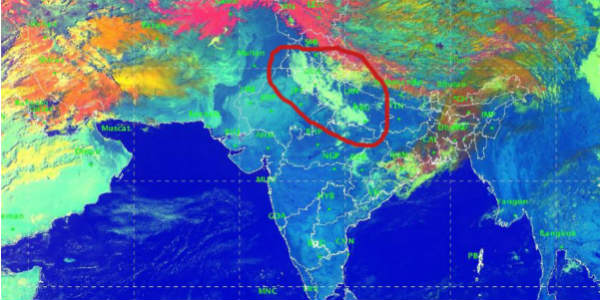
The Western Disturbance which has given widespread rainfall and snow activities recently and the system is now moving away. It’s induced Cyclonic Circulation has moved from North Rajasthan to Central Uttar Pradesh. Hence, isolated activity is expected over extreme parts of West Uttar Pradesh and Punjab. Rest places would witness dry weather for the coming 24 hours.
In the past 24 hours, most of the Northwest plains of the country remained dry with moderate to dense fog over Punjab, some parts of Haryana, Delhi and NCR, West Uttar Pradesh and Rajasthan.
The city of Amritsar in Punjab observed very dense fog wherein the visibility dropped to 150-meter for some time. Along with this, few more parts of Punjab recorded dense to very dense fog with poor visibility levels. Bareilly in Uttar Pradesh witnessed dense fog with 200-meter visibility level, followed by Lucknow, Allahabad and Delhi in moderate category with 500-meter visibility levels.
The formation of fog started last evening itself. Due to presence of strong ground winds, fog could not settle over the ground at many places and remained in the lower levels covering the sky. The minimums have dropped marginally over the Northwest plains. Now we expect moderate winds from northwest direction to blow over most parts of North India including Delhi and its nearby regions such as Noida, Gurugram, Faridabad and Ghaziabad. The day temperatures are expected to remain below normal and minimum temperatures might drop marginally during night.
As per Skymet Weather, the fog intensity is expected to improve from February 17 morning. Also, another weather system,i.e. the Western Disturbance would soon approach the Western Himalayas by February 17 and February 18 onward, we can expect another wet spell to prevail over the regions for the following days.
The pollution levels over the major cities have improved marginally for the day due to strong surface winds.
Image Credits – IMD
Any information taken from here should be credited to Skymet Weather


