Pre-Monsoon season begins in the beginning of March, also known as pre-Monsoon Cyclone season. Due to increasing heat potential in the ocean waters, the heat starts building up over the Southern Peninsula.
For the formation of a storm, the shifting of ITCZ (Inter Tropical Convergence Zone) northwards is essential. ITCZ is an equatorial trough that begins to move towards Northern Hemisphere, as the sun crosses the Equator. On March 20, which is the Spring Equinox is when the Sun passes the equator.
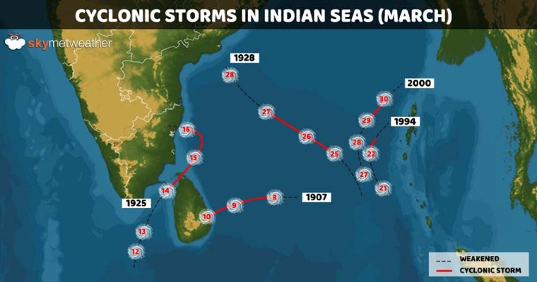
Thus, cyclonic storms can form during the latter half of March. However, the probability of the formation of cyclones is very less. In fact, there have been only 5 cyclones formed between 1900 and 2021 out of which, not even one made landfall over land as a storm.
Cyclones from 1900-2021
Also, all 5 of these Cyclones have formed in the Bay of Bengal or the Indian Ocean and none in the Arabian Sea. Due to warm waters, weather conditions for the formation of cyclones are more conducive in the Bay of Bengal. On the other hand, the Arabian Sea has colder sea temperatures.
Out of the 5, the closest and strongest storm was in 1925 around mid-march, which struck somewhere between Sri Lanka and Tamil Nadu.
The most recent cyclone in March was in the year 2000, which also has been the only cyclone of the 21st century so far. It had appeared in South Bay as a feeble system, around March 27, becoming a Cyclone by March 30, attaining speed up to 85 kmph recurving north-northeastwards. However, it lost steam before hitting any coastline as approaching landmass led to increased wind shear.
Ocean waters have an extended memory, where the duration for retention of heat or cold is much larger than land. The land sees an increase in temperatures, by 9-10 degrees in just about a month, but sea temperatures observe a change in just a few decimals that too in a series of months.
Thus, the overlapping months of March are generally devoid of any major cyclogenesis in the Indian seas. There have been few low-pressure areas or depressions that had formed in March but they could not intensify due to lack of heat potential.
Cyclone Alert For Tamil Nadu
A Depression has formed over the southwest Bay of Bengal, rather too early in the season. It is expected to move northwest and also intensify to a deep depression, shortly. The heat potential of the ocean waters and vertical wind shear is supportive of its further intensification. However, the weather system needs to be kept under observation over the next 24hr for an authentic analysis. Based on current observations, the formation of a storm in the next 48hr can not be ignored. Even if the storm forms, the steering current influenced by the tropical ridge may not permit it to travel deep inland. In case of such an eventuality, it is expected to skirt the coast, albeit in close proximity of North Tamil Nadu and South Coastal Andhra Pradesh.


