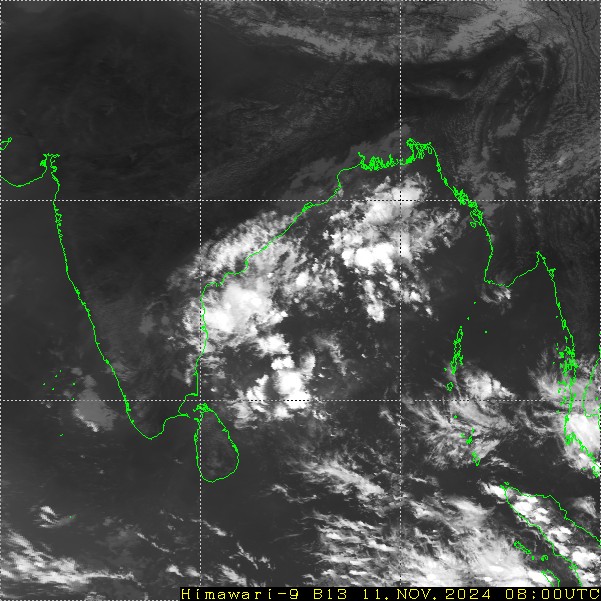
A cyclonic circulation persisted over the Southwest Bay of Bengal (BoB) for the last about two days. Under its influence, a low-pressure area is likely to form over the same region, most probably within the next 24 hours. The weather system will slowly move westward across Sri Lanka, the Gulf of Mannar, Tamil Nadu and Kerala, over the next 3-4 days. The northeast monsoon activity, which was sluggish and sleepy, for the last three days will revive soon.
The cloud cluster over southwest BoB is the manifestation of an active cyclonic circulation over the region. This is likely to get organized further and turn into a low-pressure area. The low-pressure will reach the Gulf of Mannar and Tamil Nadu coast tomorrow, the interiors of Tamil Nadu the day later and cross over to the Arabian Sea, across Kerala, subsequently. These weather systems leave a decent spell of activity in the rear section, as well. That is how, active northeast monsoon conditions are likely for the next 6-7 days, till 17th November.
The coastal parts of Andhra Pradesh and Tamil Nadu will witness scattered rain and thundershowers today and reach inland by tomorrow. The spread and intensity of weather activity will increase further from 13th Nov onwards. Most parts of Coastal Andhra Pradesh, Tamil Nadu, Puducherry, Kerala, Rayalaseema, South Interior Karnataka and Coastal Karnataka will be the chief beneficiaries. Fairly widespread rain and thundershowers are likely between 13th and 17th November. Isolated heavy rainfall is expected, more so, over the interiors of Tamil Nadu and Kerala during this period. Isolated heavy rainfall will remain confined to Coastal Andhra Pradesh and North Tamil Nadu, including Chennai for the next 48 hours. A broad clearance over the region is likely on and after 18th November.


