In the last 4 weeks, equatorial SSTs were below average across most of the Pacific Ocean. Below average sea surface temperatures persisted near the surface to at least about 100mtr depth, below the central and equatorial eastern Pacific Ocean. Above-average temperatures continue at layers deeper than this in the western and central Pacific Ocean.

Low-level easterly wind anomalies prevailed in the east-central equatorial Pacific. In all, the coupled ocean-atmosphere system continues to reflect La Nina.

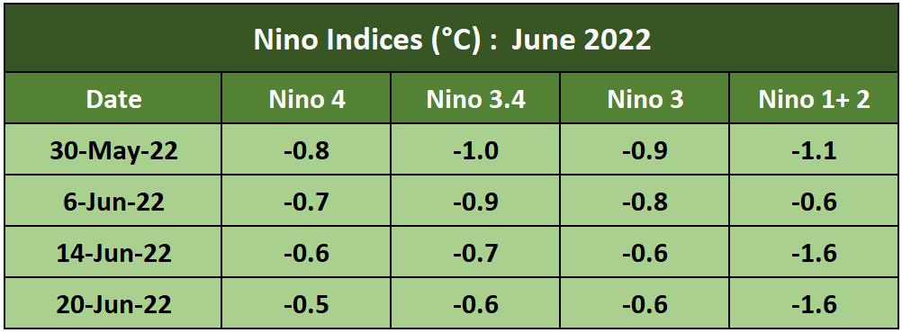
ENSO: The SSTs have consistently dropped over the last 4 weeks in the Nino 3.4 region. The average SST in the Nino 3.4 region represents the ONI ( Oceanic Nino Index) and is the principal measure for monitoring, assessing and predicting ENSO. There is a significant temperature gradient between Nino 1+2 ( coastline of South America) and Nino 4 ( equatorial west-central Pacific Ocean). All across, the SSTs in all 4 zones are below the threshold of -0.5°C.

La Nina's advisory is presently in vogue. This advisory is issued by NCEP/NOAA when El Nino or La Nina are observed and expected to continue.
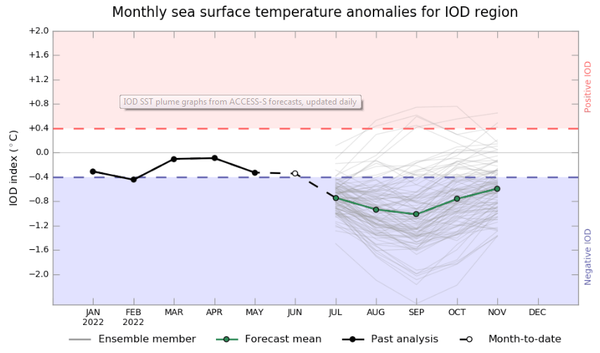
IOD: The Indian Ocean Dipole has been below 0°C since 16th May 2020. It had touched a low of -0.55°C on 23rd May and rose to be at - 0.3°C on 06th June. The current weekly value on 19th June was -0.49°C, less than the threshold mark of -0.4°C. Most models indicate that the -ve value is going to increase and a -ve IOD is almost there to follow. A -ve IOD does not go well with the monsoon activity across the Indian sub-continent. Invariably it suppresses the bursts of monsoon, more so in the core monsoon months of July and August.

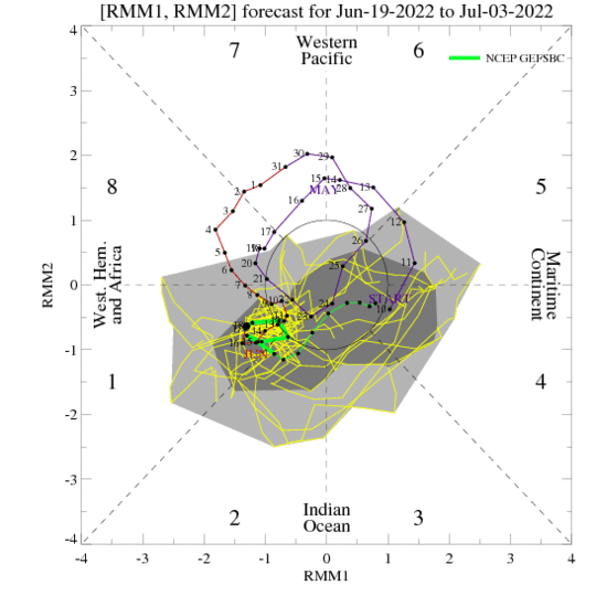
MJO: Madden Julian Oscillation is likely to uptick in amplitude over the Western Hemisphere. Earlier, as expected and predicted, it had weakened over the previous week. However, the strong MJO phase will be short-lived. Its short stay over the Indian Ocean while in phases 2 and 3 is likely to enhance the monsoon activity. Possibly, a monsoon circulation is likely to form, intensifying monsoon rainfall across the central parts of the country. Under its influence, the monsoon current is expected to advance over northern parts during the last days of June or the outset of July.

There is a bit of uncertainty over the next couple of weeks about the status of La Nina. The odds for La Nina are likely to decrease during the late summer. The ambiguity still remains as to, whether La Nina may transit to ENSO neutral during the summer, with forecasters predicting a 52% chance of La Nina and 46% chance of ENSO neutral during July-September 2022. Subsequently, with renewed cooling, La Nina is favoured again during the fall and early winter.


