The El Nino/ La Nina phenomenon is the biggest cause of year to year difference in weather in many regions. In La Nina years, the east-to-west Pacific trade winds are stronger, pushing warm surface water to the west and drawing up deeper, cooler water in the east. The El Nino event happens when the trade winds wane, allowing the warm waters to spread back eastward, smothering the cooler waters and leading to a rise in global temperature. Under climate change, the impact of El Nino events is going to get stronger and this will get superimposed on the temperature changes associated with the climate change itself. While there is generally a relationship between the global impacts of the El Nino/La Nina event and its intensity, there is always potential for an event to generate serious impacts in some regions, irrespective of intensity. Under the shadow of El Nino, the year 2009 witnessed a severe drought in India with seasonal rainfall of 78% of LPA. However, the Oceanic Nino Index was just marginal and remained confined between 0.4-0.7°C, during the monsoon months.
As per the latest case study, El Nino is more extreme when the climate is warm and that one in two events may fall into this category by 2050 due to climate change. Therefore, there is a need to reliably predict, whether El Nino/La Nina will become stronger or more frequent in the future. The occurrence of El Nino/La Nina affects the climate of much of the tropics and sub-tropics and has links (teleconnections) to higher latitude regions of the world. The estimation of the duration of the event, including commencement and cessation becomes equally important. It is a tall order to accomplish as the occurrence of ENSO by itself is not genuinely predictable, with precision. There is a constant need to upgrade the new models and improve simulations to capture El Nino/ La Nina events.

ENSO: To capture the El Nino/ La Nina developments, a set of dynamical and statistical models are run. During ENSO, the dynamical models are considered better than statistical ones for operational reasons. One of the attributes of a dynamical model is that they are run more frequently, using the most recent observed data as input. Many statistical models are built on monthly or seasonal (3 months) average data. So, by comparison, the inputs are relatively older. Therefore, the dynamical models may catch the potentially important changes, as they also use more and complex data sets. However, by virtue of a large data set, the margin of error and scope of distortion get minimized in the statistical models. Yet, the dynamical model skill is considered relatively better but still remains lower than the desired level.

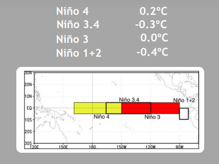
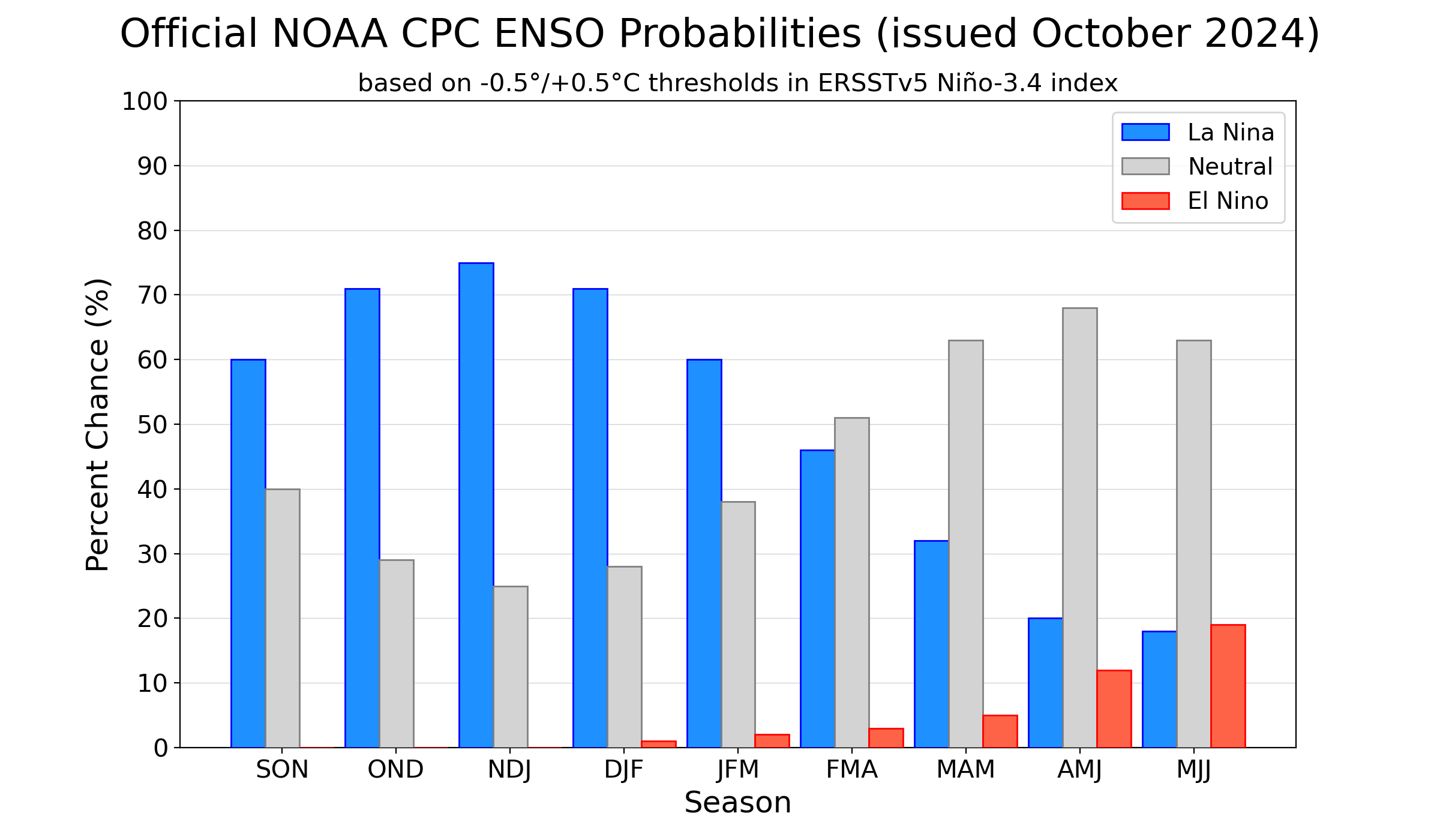
The Nino indices continue to be disorderly and still far from a stable pattern. Nino 3.4, the marker index for ONI has further risen to -0.3°C, a significant jump from its earlier value of -0.5°C on 23 Sep 2024. The mean value of the Nino 3.4 index over the last three months works out to be -0.1°C. To qualify for La Nina standards, the quarterly ONI essentially needs to be -0.5°C or less. And, this trend is forecast to stay good for the subsequent two more quarters. Formation of La Nina is unlikely in October 2024 and it may even struggle to materialize in November 2024.

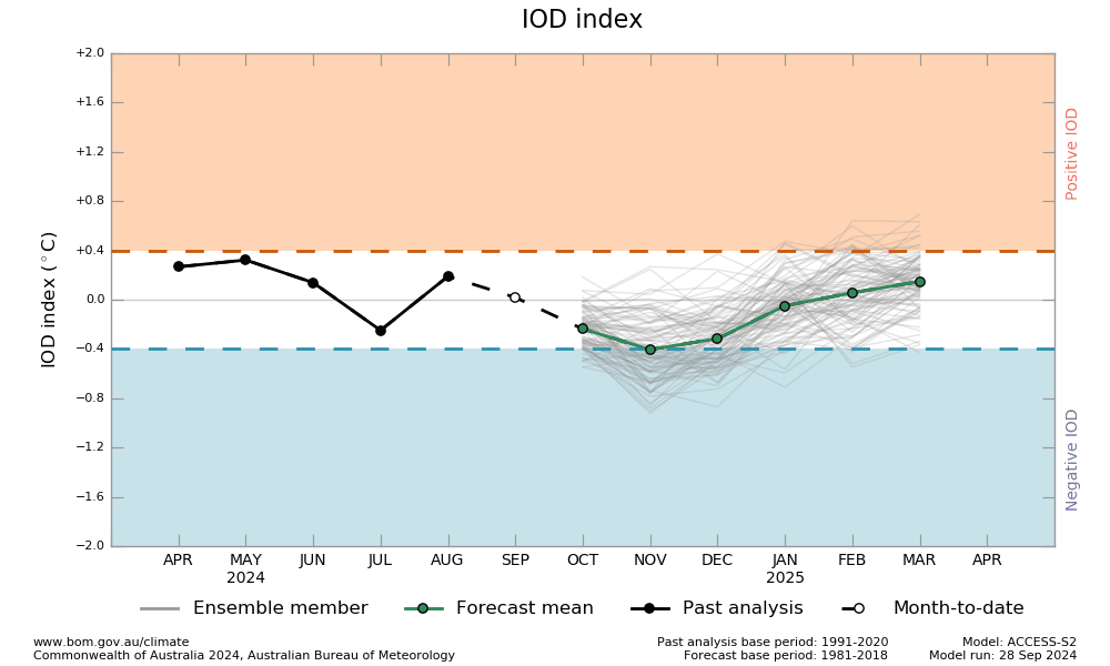
IOD: The Indian Ocean Dipole is neutral. The IOD index for the week ending 06 Oct 2024 was -0.35°C, still very close to the negative threshold mark. Most climate models indicate, that the IOD is likely to remain neutral, but weakly negative for the rest of the year. The IOD forecast skill has historically been low at this time of the year. Even, with the latest simulation techniques, IOD is difficult to predict several months in advance.

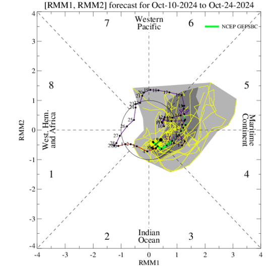
MJO: Unlike a standing pattern like the ENSO and IOD, the Madden- Julian Oscillation is a travelling pulse that propagates eastwards at approximately 4-8m/s, through the atmosphere above the warm parts of the Indian Ocean and Pacific Ocean. This overall circulation pattern manifests itself more clearly as anomalous rainfall. In the first week of October, the MJO was positioned across the Western Hemisphere, leading to an uptick in the tropical cyclone activity, across the North Atlantic. During the second week of October, the MJO propagated eastward over the Indian Ocean. Though, the amplitude reduced but still it increased the convective activity in the equatorial region, on either side of the coastline. It is likely to sail over the Maritime Continent in Phases 4 & 5 and still remain favourable for enhancing convection. It may hasten and facilitate the early start of the Northeast Monsoon over the South Peninsula.

The interaction between the atmosphere and ocean in the tropical belt of the Pacific Ocean is altering the global weather and climate patterns. The relationship between the two is very complex. While, the atmospheric changes alter the sea surface temperature and in turn, the sea surface conditions modify the atmospheric state, at least in the boundary layer. These two seem to be complementary to each other. The occurrence of El Nino/La Nina events is likely to become more frequent, intense and complicated. New and sophisticated models and the relevant expertise will have to work in tandem to improve the simulation of these events.


