Equatorial Pacific has been cooling persistently since June 2021. The central Pacific hosting El Nino/ La Nina index is cooling faster than its either flank. The Indian Ocean on the western side over the equatorial Arabian Sea is warming silently than the Pacific. IOD is also struggling to remain within the bounds of neutral conditions. The 3rd oceanic index, MJO has spent equitable time in phase 2&3 during September, a favourable zone for enhancing rainfall activity.
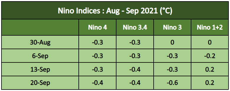
ENSO:ENSO neutral conditions are present. A transition from Neutral to La Nina is likely during the winters 2021-22. In mid-September, sea surface temperatures (SSTs) in the east-central Pacific are about -0.4°C different from the average. Key atmospheric variables are in consonance with neutral conditions. A La Nina watch is ‘on’ for September 2021.

From August 2020 to February 2021, -ve subsurface temperature anomalies persisted in the eastern half of the equatorial Pacific Ocean. Temporarily, during March through May 2021, +ve anomalies shifted eastward. Again in July, -ve subsurface temperature anomalies emerged and now in mid-September, these have strengthened in the east-central Pacific Ocean. All this goes on to indicate the tentative arrival of La Nina towards the fall of the year and the potential La Nina event during winters 2021-22 of the Northern Hemisphere. The long term projection suggests a return of ENSO neutral in late ‘spring’ and early summer of 2022.

El Nino/La Nina events tend to develop during the period Apr-Jun and they attempt to reach their maximum during Oct-Feb. These events typically persist for 9-12 months and normally occur every 2-7 years.
IOD:Indian Ocean SSTs impact rainfall and temperature pattern over Indian Sub – Continent. Warmer than average SSTs over the equatorial Indian Ocean in the proximity of the Arabian Sea provide more moisture for the monsoon systems emerging over the Indian seas. The -ve IOD event has weakened, with index values falling within the threshold of +/- 0.4°C for the last 6 weeks. This index is showing a tendency to reach 0°C by the fall of the year.

MJO:The Madden Julian Oscillation (MJO) is the largest element of intra-seasonal (30-90days) variability in the tropical atmosphere. It is a large scale coupling between atmospheric circulation and tropical deep convection. Unlike standing patterns like ENSO and IOD, the MJO is a travelling pattern that propagates eastward at approximate 4-8m/sec through the atmosphere above the warm parts of the Indian and Pacific Oceans. MJO remained in an active mode with fair amplitude over phase 2&3 in the Indian Ocean during September. Gradually, it is likely to shift to the maritime continent in phase 4&5 during the next 2 weeks.

The trio of La Nina, IOD and MJO aligned and worked in tandem to enhance the monsoon rains in September. The crippling rains of August nearly took the season to the brink of drought with pan India deficiency reaching 10% during the last week of the month. September has recorded surplus rainfall by 31% of the long-period average (LPA) so far. It is likely to increase further during the leftover days of the month. September has literally pulled the season out, from an otherwise staring drought.
