La Nina keeps cool, ENSO neutral during spring 2021

March 3, 2021 7:25 PM|

Monsoon 2021 forecast

During the last 4 weeks, sea surface temperatures (SST’s) continued to be below average across the equatorial Pacific Ocean. Apparently cooling is more prominent over West Central and Central Equatorial Pacific as compared to Eastern Equatorial Pacific. In the last week, easterly wind anomalies strengthened over the East-Central Pacific. In the last 2 months, -ve sub-surface temperature anomalies have persisted from Central to Eastern Pacific Ocean pointing to a cool thermocline (sea surface – 150mtr deep). This goes on to show that the Pacific Ocean is sufficiently mild albeit with a slow march towards neutral conditions.

La Nina

The numerical model averages predict La Nina to continue into the Northern Hemisphere Spring 2021, returning to ENSO-Neutral during April – June and persisting through fall 2021.

La Nina

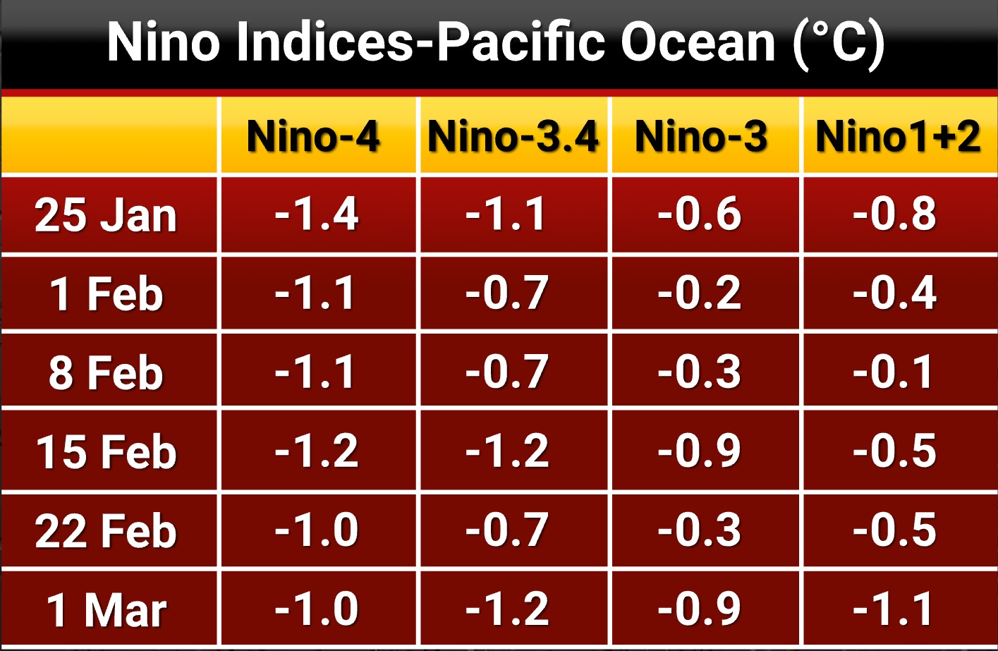
The workhorse of Skymet, numerical model CFS.V2 ensemble mean predicts borderline La Nina conditions during late Spring and early summer before strengthening through fall 2021.

La Nina

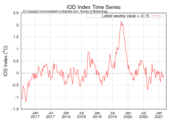
SST’s in the Indian Ocean are slightly warmer than average across most parts. The latest weekly value of the Indian Ocean Dipole (IOD) index to 28th February was -0.15°C. Most models expect it to remain neutral through the springe.

IOD

Oceanic temperature is expected to become slightly cooler than average at the commencement of Southwest Monsoon season. No big support may come from IOD in the initial phase of the monsoon.

Similar Articles

thumbnail image
March 20, Today Marks The Spring Equinox: Day-Night Duration Nearly Equal

The official transition from winter to spring, known as the SPRING EQUINOX, occurs today! It’s time when the Sun crosses the celestial equator precisely at 2:31 PM, delivering warmer, longer days to the Northern HemiSphere. As autumn arrives, the South enjoys colder evenings.

posted on:
thumbnail image
दिल्ली में बढ़ेगी गर्मी! शुष्क और तपता रहेगा वीकेंड, बारिश की संभावना हुई कम

दिल्ली में गर्मी बढ़ रही है, पिछले 3 दिनों में तापमान 4°C बढ़ा है। आज अधिकतम 34-35°C, न्यूनतम 17°C तक रह सकता है। मार्च अब तक लगभग शुष्क बना हुआ है, सिर्फ 2mm बारिश दर्ज हुई है। 26-28 मार्च को तापमान 40°C के करीब पहुंचने की संभावना है। वहीं,पश्चिमी विक्षोभ से मैदानी इलाकों में बारिश की संभावना नहीं है।

posted on:
thumbnail image
Hot Belt of 40°C Expands: Covers Odisha, Maharashtra, Telangana and Rayalaseema; Relief Likely

Heatwave conditions are setting in much earlier than usual this year, with temperatures soaring past 40°C in Odisha, Maharashtra, Telangana, and Andhra Pradesh. Slight relief is expected as rain and thunderstorms are likely between March 21-24 across several states.

posted on:
thumbnail image
[Hindi] सम्पूर्ण भारत का मार्च 21, 2025 का मौसम पूर्वानुमान

अगले 24 घंटे के दौरान, पश्चिम बंगाल, झारखंड, मणिपुर, मिजोरम, त्रिपुरा और उत्तर छत्तीसगढ़ में हल्की से मध्यम बारिश और गरज के साथ बिजली चमकने तथा तेज हवाओं की संभावना है।

posted on: