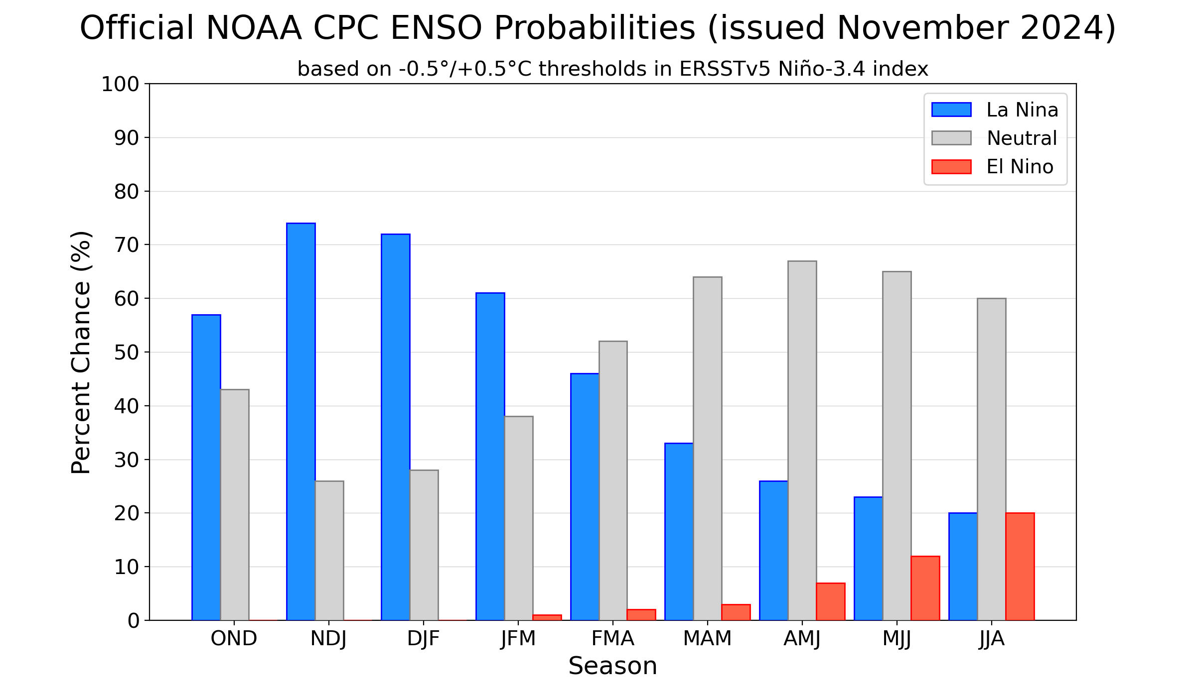
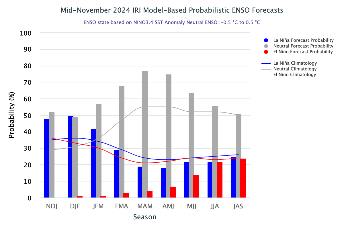
ENSO-neutral conditions persist in the equatorial Pacific Ocean. Both, the ocean and atmospheric indicators remain in an ENSO-Neutral state. Usually, La Nina intensifies the normal circulation of the atmosphere over the tropical Pacific Ocean. However, off late, there is a sustained weakening of trade winds which does not augur well for the development of La Nina conditions. The official CPC ENSO probability forecast and the objective model-based IRI ENSO probability forecast, are often quite similar. Occasionally, they may differ noticeably and this difference will stand to reason and logic. However, these two forecasts, in the month of November 2024 have conflicting inferences. While the CPC forecast is aligned with the onset of La Nina in the quarter Oct-Nov-Dec 2024 with a fair amount of confidence, but the objective IRI ENSO outlook indicates a continuation of ENSO -Neutral for Nov-Dec-Jan 2025. As per this, La Nina scores over ENSO-Neutral marginally, for a short period of just one, three-month period during Dec-Jan-Feb 2025.
The planetary scale phenomena like La Nina/El Nino have no evidence of such truncated episodes in the past. Since 1950, the shortest duration of La Nina is on record for a five, three-month period during the fall of 1983-84, 2005-06 and 2016. The latest Nino indices configuration in the tropical Pacific Ocean does not emphatically support a clear La Nina event, this season.
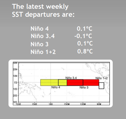
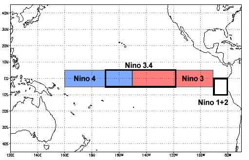
ENSO: Monitoring Of ENSO conditions primarily focuses on SST anomalies in four geographical regions of the equatorial Pacific Ocean. SST anomalies equal to or less than -0.5°C in the Nino 3.4 region ( 170°W-120°W) are associated with cool phase La Nina conditions. Nino 3.4 SST anomalies are averaged over the three months ending with the current month and that value is called the ‘Oceanic Nino Index’( ONI). If the ONI exhibits warm or cool phase conditions for at least five consecutive values, it officially becomes an El Nino or La Nina event. The chances of having such an event look rare and remote, this season.

All the Nino indices exhibit minimal changes except Nino1+2. Coastline fluctuations are very common but Nino 1+2 is rather warm. The mean value of Nino 3.4 for Oct-Nov 2024 works out to -0.28°C. Even if all the five weekly indices in Dec2024 drop to -0.5°C, the average for Oct-Nov-Dec will remain at -0.4°C. It still falls short of -0.5°C, the least threshold mark for La Nina. With this, the appearance of La Nina in the year 2024 is nearly ruled out and the focus now shifts to the next quarter Nov-Dec- Jan 2025.

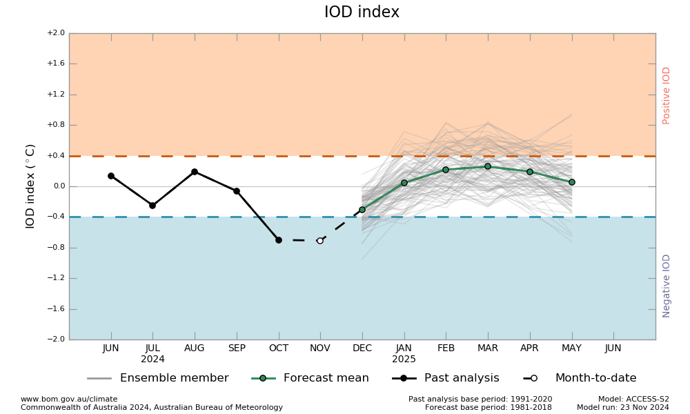
IOD: The Indian Ocean Dipole has been below the negative IOD threshold (-0.4°C) since mid-October 2024. The latest value of the IOD index was -0.54°C for the week ending 24 Nov 2024. To be classified as a negative IOD event, the index needs to be below the threshold for at least 8 weeks. It means, that if the IOD index remains below the threshold for another week, it would indicate a negative IOD event is underway. Going by the historical records in a typical IOD event life cycle, the index turns neutral in Dec/Jan.
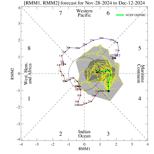
MJO: Nearly all the models favour continued eastward propagation of the Madden-Julian Oscillation in the Maritime Continent. However, loss of amplitude is envisaged, as it nears the Western Pacific around mid-December. Positioning of MJO over the Maritime Continent augurs well for cyclonic activity over the Indian Seas. However, the shearing environment leaves unfavourable and lesser chances of the development of any storm in week 2 over the Indian region.
The ENSO, IOD and MJO are broad indicators of the climate pattern over different parts of the globe. The seasonal pattern over the regional geographical divisions matters the most. The mountains over North India have omitted the active western disturbance and the entire region is alarmingly snow deficit. The Northeast Monsoon over the South Peninsula has barely managed a satisfactory note. Kerala and Coastal Andhra Pradesh are borderline deficit and have a shortfall of over 20%. The deep depression over the Bay of Bengal, moving across the region, may save the grace. October and November have figured amongst the warmest months. Large hopes are pinned in December to accomplish the daunting task ahead.


