The ENSO is a recurring climatic pattern involving temperature changes in the waters of the eastern and central tropical Pacific Ocean, and changes in the patterns of upper and lower-level winds, sea level pressure and tropical rainfall across the Pacific Basin. The deviations can result chaotic weather conditions around the globe and overall climate.
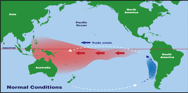
La Nina means, the water temperatures in the eastern Pacific gets colder than normal. So, there is high pressure belt over eastern equatorial Pacific and low pressure on the western side, off Asia. La Nina causes drought in Peru and Ecuador, high temperature over Indian Ocean, off the Somalian coast, and good monsoon rains in India.
Since 1950, out of 13 droughts, 10 have been during El Nino years, 2 in ENSO neutral (1966, 1979) and one in La Nina year (1974). Also, since 1950, there have been 22 La Nina years. These include four episodes of triple dip La Nina: 1954-56, 1973-75, 1998-2000 and 2020-22. Triple dip La Nina more often get followed by El Nino year, of course, with some exceptions. Monsoon rainfall in La Nina years during 1950’s, 60’s and 70’s was generally above normal or excess, except in 1974, which was a drought year. Monsoon rainfall was below normal in 1985 and 2000. Also, the seasonal rainfall was at the lowest end of normal in 1999 and 2016, measuring 96% and 97% of LPA, respectively. It means, La Nina by itself may not suffice to secure the southwest monsoon.
Occurrence of La Nina and positive IOD together is not very common. Since 1954, it occurred only once in 2007 and the season recorded 106% rainfall of LPA. La Nina and IOD data read together lead to an important finding, viz: La Nina and +Ve/ +Ve neutral IOD becomes safe bet for the Indian monsoon. Negative or negative neutral IOD may suppress the scale of monsoon rains, even with La Nina around, as it happened in 2016, when season ended with 97% rainfall of LPA.
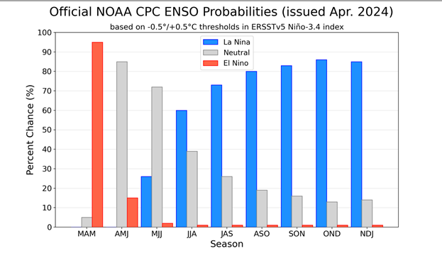
ENSO: As per Bureau of Meteorology, global sea surface temperatures (SSTs) have been the warmest on record for each month between April 2023 and March 2024. April 2024 data, so far, is also on the same track and warmer than April 2023. The global pattern of warmth is interfering with typical warming/cooling of the Pacific Ocean associated with ENSO neutrality. The current global conditions seem to be ambiguous enough for any conclusive predictions on ENSO variability. As such, El Nino and La Nina predictions made around this time tend to have lower accuracy. Therefore, the current forecast need to be treated with caution, more so for the second half of the season.

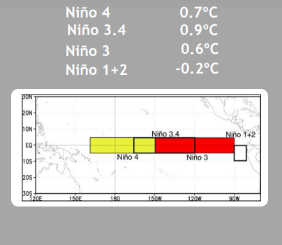
All the four Nino indices in the Pacific have cooled marginally over the last one week. This is supported by sub-surface cooling underneath the central and eastern equatorial Pacific. These are typical of El Nino inching towards ENSO neutral and the change over is likely by middle of next month.
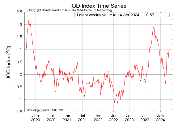
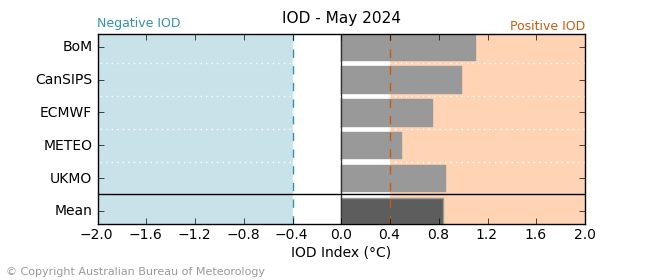
IOD: The most recent value of the Indian Ocean Dipole for the week ending 14thApril 2024 was +0.57°C. Though, this value is above the positive IOD threshold, the IOD will still be considered neutral as the event is yet to form. It need consistent values above the threshold for at least 8 weeks. Yet, there are enough indicators that a positive IOD is likely to develop, coinciding with arrival of southwest monsoon over Indian region. If so, very rare event otherwise, of La Nina and positive IOD together, will go on record for the second time, since 1954.
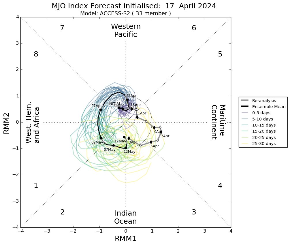
MJO: Madden-Julian Oscillation is currently weak. The amplitude is confined deep in the inner circle. MJO will remain indiscernible for the next one week. It is expected to move over Western Pacific first and later propagate to Western Hemisphere and Africa, as a weak pulse. It is likely to transit over the Indian Ocean during first week of May. It is unlikely to render any support for triggering deep convection to activate pulse of rain and clouds along the equatorial belt.
Rare combination of positive IOD and La Nina is surely promising better prospects for monsoon 2024. However, the question still remains, as to, when does ENSO turns neutral and La Nina advisory begins. It is very essential for Positive IOD and La Nina to remain in phase for sufficient duration to trigger monsoon bursts. Weak and silent MJO reveals least possibility of maiden pre monsoon cyclone during this month in the Indian seas.