
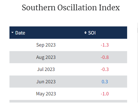
El Nino and IOD are both active over the respective Pacific and Indian Oceans. The Southern Oscillation Index (SOI) is also striding to keep pace with Oceanic Nino Index (ONI). A negative SOI and moderate El Nino invariably become synonymous during the periodic fluctuation of pressure and temperature over the equatorial Pacific Ocean. The reason behind the warming and cooling of the Nino regions remains an alien territory but the two components of ENSO – sea surface temperature and atmospheric pressure display strong binding.

ENSO: El Nino's impact on the southwest monsoon just got concluded. During the El Nino event, as it usually happens, the easterly trade winds converging across the equatorial Pacific remained weak, more so, during the 2nd half of the season. This restricted the upwelling of cold water and allowed warm surface water to dig deep over the eastern parts of the basin. The southwest monsoon 2023 of the Indian sub-continent finds a distant reflection of the El Nino 2018-19 season. El Nino is predicted to continue through the Northern Hemisphere winters and weaken to become ENSO-neutral during the spring season of 2024.

Oceanic indicators strongly exhibit an El Nino state. All the Nino indices remain above the threshold by a sufficient margin. Nino 3.4, the principal measure for predicting ENSO and the sole measure of Oceanic Nino Index (ONI) firmly support the ongoing event. The ONI for the last two quarters, Jun-Jul-Aug and Jul-Aug-Sep, with respective values of 1.1 and 1.3, strongly defend the ocean-atmosphere coupling. ONI is anticipated to exceed 1.3 for the next quarter, as well.

IOD: The positive Indian Ocean Dipole continue to strengthen. The latest value of the index for the week ending 08 Oct 2023 was 1.85°C. This is the highest score since October 2019 when the index reached an all time of 2.15°C during the week 07-13 October 2019. Earlier, ever increasing positive dipole index saved monsoon 2019 from scare of drought. Season 2019, opening with a terrible deficit of 33% rainfall in June, recovered to register surplus of 15% in the core monsoon month of August and a deluge with excess of 53% rainfall in the closing month of September. Indian Summer Monsoon Rainfall (ISMR) nearly ended in excess recording 109.96% rainfall of LPA. But for the positive IOD, evolving just in time, during late August and September, monsoon 2023 could have reached on the brink of yet another drought. August 2023, with a pitiable all time high deficit of 36% rainfall, nearly dragged the monsoon towards scary finish. Rising IOD index from 1°C in first week to 1.5°C at the end, neutralized ill effects of El Nino, to save grace of the season, ending below normal at 94% of LPA.

Positive IOD event is likely to continue. It is expected to peak in November-December. This means that South Arabian Sea in the proximity of equatorial Indian Ocean is likely to stay warmer during the northeast monsoon season. This also translates in to better rainfall distribution and spread over South Peninsular India during the winter monsoon 2023. The IOD event, as it usually happens, starts fading out during the winters and early spring of Northern Hemisphere.
MJO: Although, far from the area of our context, the Madden-Julian Oscillation has reflected spike in the amplitude over the past pew days. Currently, it is placed over Western Hemisphere in phase-1, with enhanced cycle of activity. The atmospheric response to ongoing El Nino conditions is also playing a significant role in the tropical convective pattern, accentuating ‘pulse’ of cloud and rain associated with MJO. However, the growing positive IOD event may increasingly interfere with the growing signal of MJO, as it propagates eastward. The amplitude of MJO is likely to slash and remain confined to the inner ring, as it travels to phase-2 over the Indian Ocean in the 3rd week of October. Tropical cyclone activity is likely over Western Pacific and South China Sea. Also, favourable potential for weather perturbations over the Arabian Sea due to warm sea surface. Yet, it may not amplify to a storm due to lack of environmental support.
Southwest monsoon is on the verge of complete withdrawal from the Indian region. No powerful trigger in sight, so far, for early arrival of northeast monsoon over South Peninsula. Northeasterly flow is surely getting aligned over Bay of Bengal, a pre-requisite for onset of winter monsoon over southern parts of the country.
